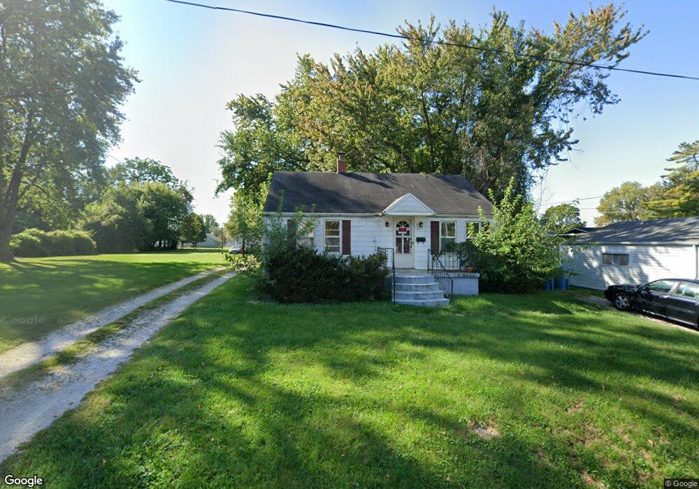
115 Clark St Collinsville, IL 62234
Estimated Value: $103,000 - $155,000
2
Beds
1
Bath
930
Sq Ft
$142/Sq Ft
Est. Value
About This Home
This home is located at 115 Clark St, Collinsville, IL 62234 and is currently estimated at $131,713, approximately $141 per square foot. 115 Clark St is a home located in Madison County with nearby schools including John A Renfro Elementary School, Dorris Intermediate School, and Collinsville Middle School.
Ownership History
Date
Name
Owned For
Owner Type
Purchase Details
Closed on
Oct 23, 2017
Sold by
Schmittling Wendy
Bought by
Borgmeyer Ethan J
Current Estimated Value
Home Financials for this Owner
Home Financials are based on the most recent Mortgage that was taken out on this home.
Original Mortgage
$32,800
Interest Rate
3.83%
Mortgage Type
New Conventional
Create a Home Valuation Report for This Property
The Home Valuation Report is an in-depth analysis detailing your home's value as well as a comparison with similar homes in the area
Home Values in the Area
Average Home Value in this Area
Purchase History
| Date | Buyer | Sale Price | Title Company |
|---|---|---|---|
| Borgmeyer Ethan J | $41,000 | First American Title |
Source: Public Records
Mortgage History
| Date | Status | Borrower | Loan Amount |
|---|---|---|---|
| Closed | Borgmeyer Ethan J | $32,800 |
Source: Public Records
Tax History Compared to Growth
Tax History
| Year | Tax Paid | Tax Assessment Tax Assessment Total Assessment is a certain percentage of the fair market value that is determined by local assessors to be the total taxable value of land and additions on the property. | Land | Improvement |
|---|---|---|---|---|
| 2024 | $2,304 | $36,040 | $7,200 | $28,840 |
| 2023 | $2,304 | $33,350 | $6,660 | $26,690 |
| 2022 | $2,195 | $30,040 | $5,960 | $24,080 |
| 2021 | $1,949 | $28,220 | $5,600 | $22,620 |
| 2020 | $1,879 | $26,920 | $5,340 | $21,580 |
| 2019 | $1,829 | $26,000 | $5,160 | $20,840 |
| 2018 | $1,547 | $21,310 | $4,870 | $16,440 |
| 2017 | $1,113 | $20,880 | $4,770 | $16,110 |
| 2016 | $1,163 | $20,880 | $4,770 | $16,110 |
| 2015 | $1,256 | $20,340 | $4,650 | $15,690 |
| 2014 | $1,256 | $12,470 | $4,650 | $7,820 |
| 2013 | $1,256 | $12,470 | $4,650 | $7,820 |
Source: Public Records
Map
Nearby Homes
- 1224 Cedar Ridge Ct
- 308 Brown Ave
- 617 N Morrison Ave
- 1120 Williams St
- 4 Delta Dr
- 5 Brookwood Dr
- 22 Brookwood Dr
- 123 W Wickliffe Ave
- 0 Strong Ave
- 414 Bunker Hill Dr
- 1210 Constance St
- 123 Elliot St
- 501 Spring
- 0 N Keebler Ave
- 203 Greenfield Dr
- 580 N Guernsey St
- 510 N Combs Ave
- 0 Elm St
- 1121 Carraway Ct
- 919 Vine St
- 115 Clark St Unit A
- 115A Clark St
- 1102 Virginia St
- 1104 Virginia St
- 1106 Virginia St
- 1010 Virginia St
- 109 Clark St
- 1108 Virginia St
- 114 Brennan Ave
- 1101 Virginia St
- 107 Clark St
- 1105 Virginia St
- 1200 Cedar Ridge Ct
- 1201 Cedar Ridge Ct
- 114 Clark St
- 204 Lee Ave
- 1203 Woodbridge St
- 203 Lee Ave
- 1103 Virginia St
- 1009 N Center St