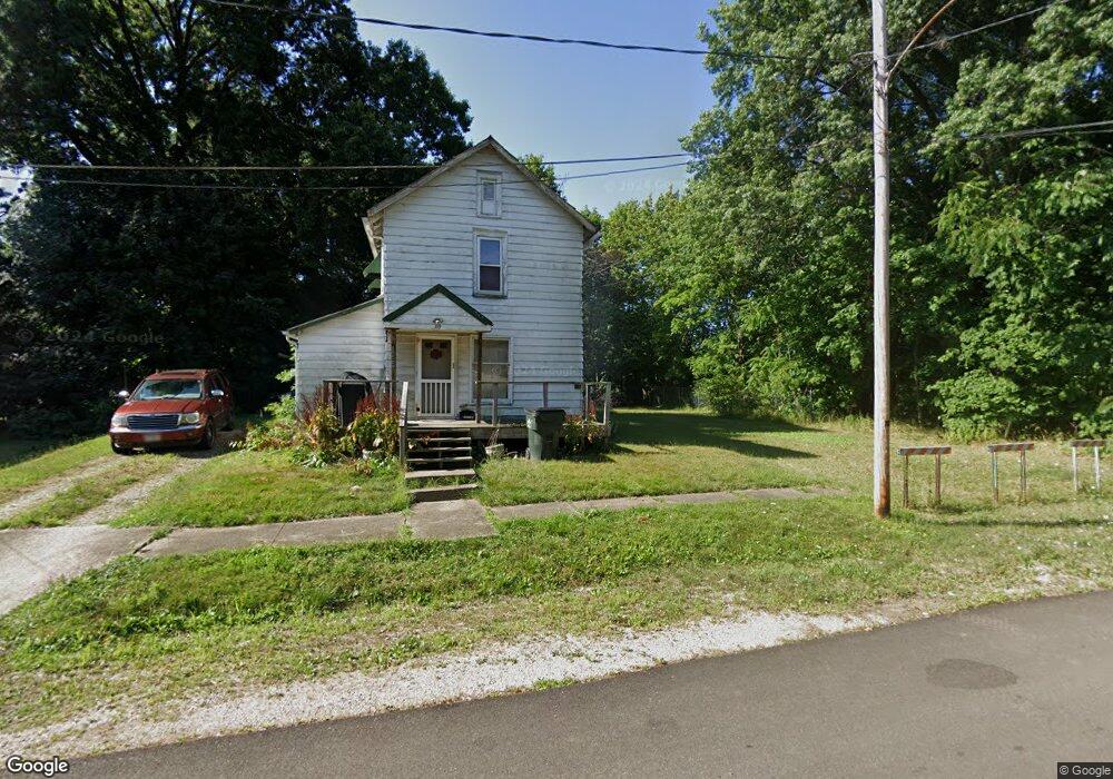
115 E Cambridge St Alliance, OH 44601
Estimated Value: $53,000 - $76,000
2
Beds
1
Bath
924
Sq Ft
$73/Sq Ft
Est. Value
About This Home
This home is located at 115 E Cambridge St, Alliance, OH 44601 and is currently estimated at $67,413, approximately $72 per square foot. 115 E Cambridge St is a home located in Stark County with nearby schools including Alliance Intermediate School at Northside, Alliance Elementary School at Rockhill, and Alliance Middle School.
Ownership History
Date
Name
Owned For
Owner Type
Purchase Details
Closed on
Dec 28, 2012
Sold by
Tanner Michele L
Bought by
Jordan Ricky Lee
Current Estimated Value
Purchase Details
Closed on
Dec 18, 2007
Sold by
Fannie Mae
Bought by
Tanner Michele L
Purchase Details
Closed on
May 15, 2007
Sold by
Moser Brian L and Moser Deborah D
Bought by
Federal National Mortgage Association
Purchase Details
Closed on
Oct 3, 2003
Sold by
Barron Anita M and Barron Joseph R
Bought by
Moser Brian L
Purchase Details
Closed on
Sep 16, 2002
Sold by
Ferguson James W
Bought by
Barron Anita M
Purchase Details
Closed on
Jan 14, 1991
Create a Home Valuation Report for This Property
The Home Valuation Report is an in-depth analysis detailing your home's value as well as a comparison with similar homes in the area
Home Values in the Area
Average Home Value in this Area
Purchase History
| Date | Buyer | Sale Price | Title Company |
|---|---|---|---|
| Jordan Ricky Lee | $9,900 | None Available | |
| Tanner Michele L | $6,000 | Attorney | |
| Federal National Mortgage Association | $26,000 | None Available | |
| Moser Brian L | $38,500 | Tower City Title Agency Llc | |
| Barron Anita M | $10,000 | Union Title Company | |
| -- | $1,500 | -- |
Source: Public Records
Tax History
| Year | Tax Paid | Tax Assessment Tax Assessment Total Assessment is a certain percentage of the fair market value that is determined by local assessors to be the total taxable value of land and additions on the property. | Land | Improvement |
|---|---|---|---|---|
| 2025 | $330 | $8,540 | $5,740 | $2,800 |
| 2024 | $371 | $8,540 | $5,740 | $2,800 |
| 2023 | $361 | $7,780 | $3,120 | $4,660 |
| 2022 | $315 | $7,780 | $3,120 | $4,660 |
| 2021 | $315 | $7,780 | $3,120 | $4,660 |
| 2020 | $274 | $6,310 | $2,700 | $3,610 |
| 2019 | $270 | $6,170 | $2,700 | $3,470 |
| 2018 | $265 | $6,170 | $2,700 | $3,470 |
| 2017 | $233 | $5,330 | $2,280 | $3,050 |
| 2016 | $235 | $5,330 | $2,280 | $3,050 |
| 2015 | $118 | $5,330 | $2,280 | $3,050 |
| 2014 | $251 | $5,390 | $2,030 | $3,360 |
| 2013 | $129 | $5,390 | $2,030 | $3,360 |
Source: Public Records
Map
Nearby Homes
- 0 E Oxford St
- 62 E High St
- 427 S Union Ave
- 726 S Arch Ave
- 807 S Union Ave
- 46 Rosenberry St
- 452 E Summit St
- 234 Rosenberry St
- 226 Milner St
- V/L S Freedom Ave
- 62 E Market St
- 134 11th St
- 228 W Oxford St
- 203 Glamorgan St
- 167 11th St
- 361 E Main St
- 442 S Liberty Ave
- 163 W Market St
- 264 W Market St
- 535 S Mckinley Ave
- 125 E Cambridge St
- 107 E Cambridge St
- 641 Summit Ct
- 143 E Cambridge St
- 116 E Cambridge St
- 651 Summit Ct
- 118 E Cambridge St
- 153 E Cambridge St
- 661 Summit Ct
- 61 E Cambridge St
- 163 E Cambridge St
- 74 E Cambridge St
- 59 E Cambridge St
- 635 S Mechanic Ave
- 175 E Cambridge St
- 164 E Cambridge St
- 39 E Cambridge St
- 657 S Mechanic Ave
- 143 E Oxford St
- 143 E Oxford St
Your Personal Tour Guide
Ask me questions while you tour the home.