Estimated Value: $156,000 - $187,460
3
Beds
1
Bath
942
Sq Ft
$184/Sq Ft
Est. Value
About This Home
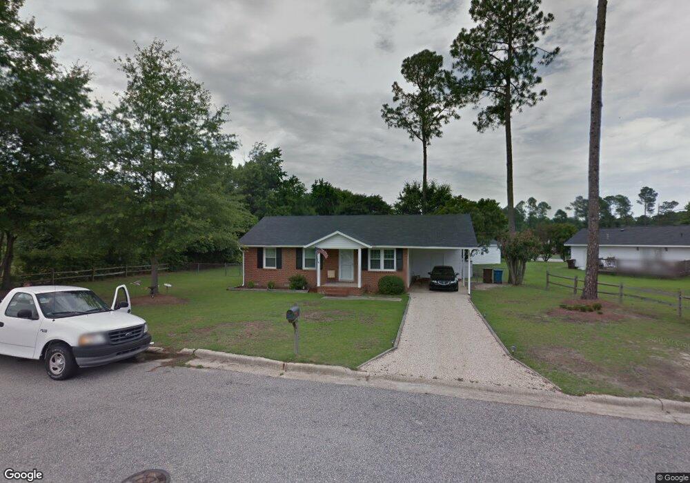
This home is located at 115 Evergreen Ln, Dunn, NC 28334 and is currently estimated at $173,115, approximately $183 per square foot. 115 Evergreen Ln is a home located in Harnett County with nearby schools including Dunn Elementary School, Dunn Middle School, and Triton High School.
Ownership History
Date
Name
Owned For
Owner Type
Purchase Details
Closed on
Apr 14, 2009
Sold by
Carroll Jeffrey and Carroll Jeffrey L
Bought by
Maynor Donald and Maynor Ruth
Current Estimated Value
Home Financials for this Owner
Home Financials are based on the most recent Mortgage that was taken out on this home.
Original Mortgage
$74,900
Outstanding Balance
$47,628
Interest Rate
5.05%
Mortgage Type
Purchase Money Mortgage
Estimated Equity
$125,487
Purchase Details
Closed on
Mar 24, 2008
Sold by
Secretary Of Hud Of Washington Dc
Bought by
Carroll Jeffrey
Purchase Details
Closed on
Jul 23, 2007
Sold by
Wells Fargo Bank Na
Bought by
Seceretary Of Hud
Purchase Details
Closed on
May 18, 2007
Sold by
Cole William
Bought by
Wells Fargo Bank Na
Create a Home Valuation Report for This Property
The Home Valuation Report is an in-depth analysis detailing your home's value as well as a comparison with similar homes in the area
Home Values in the Area
Average Home Value in this Area
Purchase History
| Date | Buyer | Sale Price | Title Company |
|---|---|---|---|
| Maynor Donald | $74,000 | -- | |
| Carroll Jeffrey | -- | -- | |
| Seceretary Of Hud | -- | None Available | |
| Wells Fargo Bank Na | $75,456 | None Available |
Source: Public Records
Mortgage History
| Date | Status | Borrower | Loan Amount |
|---|---|---|---|
| Open | Maynor Donald | $74,900 |
Source: Public Records
Tax History
| Year | Tax Paid | Tax Assessment Tax Assessment Total Assessment is a certain percentage of the fair market value that is determined by local assessors to be the total taxable value of land and additions on the property. | Land | Improvement |
|---|---|---|---|---|
| 2025 | $1,676 | $121,408 | $0 | $0 |
| 2024 | $1,634 | $121,408 | $0 | $0 |
| 2023 | $1,585 | $121,408 | $0 | $0 |
| 2022 | $1,144 | $121,408 | $0 | $0 |
| 2021 | $1,144 | $77,840 | $0 | $0 |
| 2020 | $1,144 | $77,840 | $0 | $0 |
| 2019 | $1,113 | $77,840 | $0 | $0 |
| 2018 | $1,129 | $77,840 | $0 | $0 |
| 2017 | $1,129 | $77,840 | $0 | $0 |
| 2016 | $1,202 | $83,220 | $0 | $0 |
| 2015 | $1,185 | $83,220 | $0 | $0 |
| 2014 | $1,185 | $83,220 | $0 | $0 |
Source: Public Records
Map
Nearby Homes
- 112 Gulf Dr
- 119 Gulf Dr
- 97 Rollingwood Dr
- 00000 Fairground Rd
- 4.47 Ac Fairground Rd
- 173 Jernigan Rd
- 140 Rollingwood Dr
- 711 Memorial Ave
- 1503 Fairview St
- 0 Us 301 North Hwy
- 0 Hobson Rd Unit 10131766
- 1210 Guy Ave
- 396 Riley Vann Ln
- 1108 Friendly Rd
- 1116 Friendly Rd
- 1842 N Ellis Ave
- 0 N Ellis Ave Unit 10135627
- 116 Jones Dr
- 3398 Meadowlark Rd
- 103 Byrd Dr
Your Personal Tour Guide
Ask me questions while you tour the home.