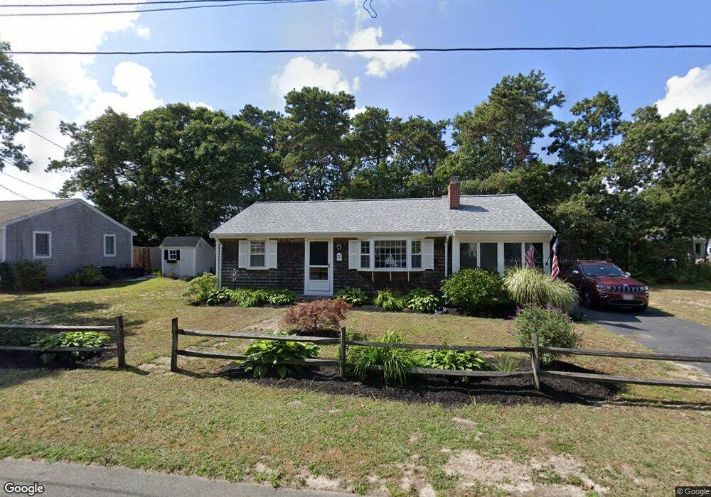
115 Kibby Ln Dennis Port, MA 02639
Dennis Port NeighborhoodEstimated Value: $504,000 - $590,000
3
Beds
1
Bath
992
Sq Ft
$557/Sq Ft
Est. Value
About This Home
This home is located at 115 Kibby Ln, Dennis Port, MA 02639 and is currently estimated at $552,728, approximately $557 per square foot. 115 Kibby Ln is a home located in Barnstable County with nearby schools including Dennis-Yarmouth Regional High School and St. Pius X. School.
Ownership History
Date
Name
Owned For
Owner Type
Purchase Details
Closed on
Oct 20, 2025
Sold by
Quin Christopher and Quin Marianne
Bought by
Quin Marianne
Current Estimated Value
Purchase Details
Closed on
Jun 8, 2023
Sold by
Quin Ft and Quin
Bought by
Quin Christopher and Quin Marianne
Purchase Details
Closed on
Feb 1, 2007
Sold by
Quin Madeleine M
Bought by
Quin Ft and Quin
Create a Home Valuation Report for This Property
The Home Valuation Report is an in-depth analysis detailing your home's value as well as a comparison with similar homes in the area
Home Values in the Area
Average Home Value in this Area
Purchase History
| Date | Buyer | Sale Price | Title Company |
|---|---|---|---|
| Quin Marianne | -- | -- | |
| Quin Christopher | -- | None Available | |
| Quin Ft | -- | -- | |
| Quin Ft | -- | -- |
Source: Public Records
Tax History Compared to Growth
Tax History
| Year | Tax Paid | Tax Assessment Tax Assessment Total Assessment is a certain percentage of the fair market value that is determined by local assessors to be the total taxable value of land and additions on the property. | Land | Improvement |
|---|---|---|---|---|
| 2025 | $2,199 | $507,900 | $195,300 | $312,600 |
| 2024 | $2,054 | $467,900 | $187,800 | $280,100 |
| 2023 | $1,987 | $425,400 | $170,700 | $254,700 |
| 2022 | $1,918 | $342,500 | $153,800 | $188,700 |
| 2021 | $5,112 | $327,400 | $172,300 | $155,100 |
| 2020 | $4,077 | $291,500 | $150,800 | $140,700 |
| 2019 | $2,771 | $272,800 | $147,800 | $125,000 |
| 2018 | $4,531 | $256,100 | $140,700 | $115,400 |
| 2017 | $4,336 | $246,700 | $130,700 | $116,000 |
| 2016 | $1,551 | $237,500 | $140,700 | $96,800 |
| 2015 | $1,520 | $237,500 | $140,700 | $96,800 |
| 2014 | $1,380 | $217,400 | $120,600 | $96,800 |
Source: Public Records
Map
Nearby Homes
- 19 Standish Way
- 80 Michaels Ave
- 4 Coffey Ln
- 22 Wixon Rd
- 31 Easy St
- 71 Main St
- 125 Main St Unit 3
- 12 Spoonbill Rd
- 72 Bassett Ln
- 268 Main St
- 15 Woodside Park Rd
- 37 Ocean Dr Unit 2
- 95 Center St
- 64 Beaten Rd
- 26 Center St
- 22 Ferncliff Rd
- 61 Trotters Ln
- 37 Beach Hills Rd
- 37-A Beach Hills Rd
- 112 Old Wharf Rd Unit E4