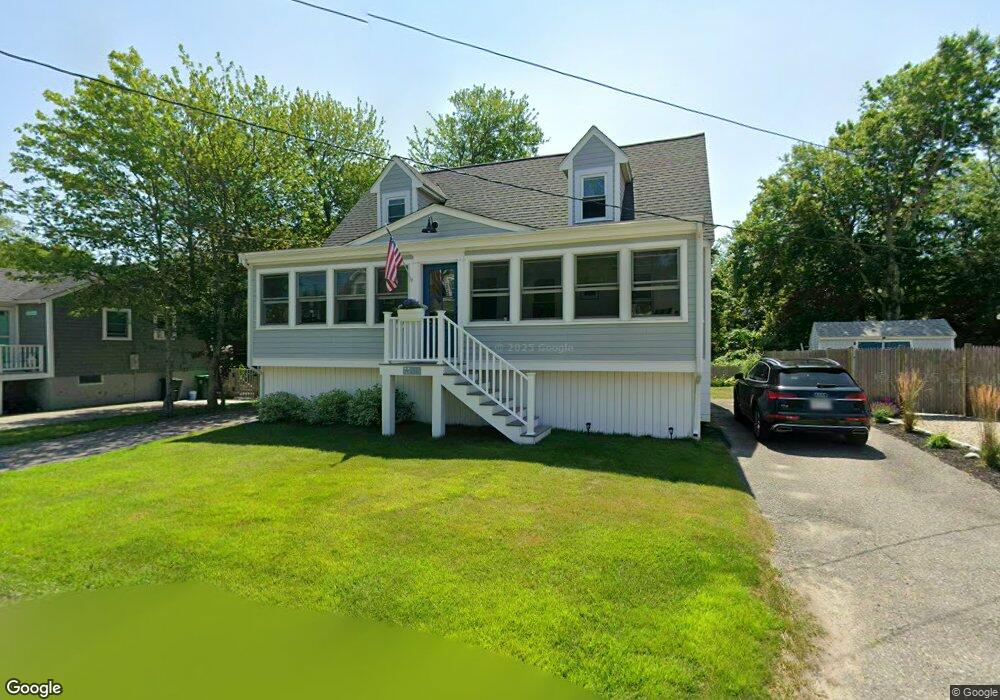
115 Monitor Rd Unit 1 Marshfield, MA 02050
Ocean Bluff-Brant Rock NeighborhoodEstimated Value: $736,900 - $830,000
3
Beds
2
Baths
1,512
Sq Ft
$512/Sq Ft
Est. Value
About This Home
This home is located at 115 Monitor Rd Unit 1, Marshfield, MA 02050 and is currently estimated at $774,225, approximately $512 per square foot. 115 Monitor Rd Unit 1 is a home located in Plymouth County with nearby schools including Daniel Webster, Furnace Brook Middle School, and Marshfield High School.
Ownership History
Date
Name
Owned For
Owner Type
Purchase Details
Closed on
Feb 17, 2025
Sold by
115 Monitor Road Ret and Smith
Bought by
Smith Ft and Smith
Current Estimated Value
Purchase Details
Closed on
Oct 20, 2017
Sold by
Smith Katherine M and Smith William C
Bought by
115 Monitor Road Ret and Smith
Purchase Details
Closed on
Oct 30, 1997
Sold by
Adams Elizabeth A and Adams Scott G
Bought by
Feeney Stephen P
Home Financials for this Owner
Home Financials are based on the most recent Mortgage that was taken out on this home.
Original Mortgage
$125,600
Interest Rate
7.31%
Mortgage Type
Purchase Money Mortgage
Purchase Details
Closed on
Aug 31, 1994
Sold by
Jcrc Rt and Clancy
Bought by
Adams Scott G and Lanagan Elizabeth A
Home Financials for this Owner
Home Financials are based on the most recent Mortgage that was taken out on this home.
Original Mortgage
$126,825
Interest Rate
8.44%
Mortgage Type
Purchase Money Mortgage
Create a Home Valuation Report for This Property
The Home Valuation Report is an in-depth analysis detailing your home's value as well as a comparison with similar homes in the area
Home Values in the Area
Average Home Value in this Area
Purchase History
| Date | Buyer | Sale Price | Title Company |
|---|---|---|---|
| Smith Ft | -- | None Available | |
| 115 Monitor Road Ret | -- | -- | |
| Feeney Stephen P | $167,500 | -- | |
| Adams Scott G | $133,500 | -- |
Source: Public Records
Mortgage History
| Date | Status | Borrower | Loan Amount |
|---|---|---|---|
| Previous Owner | Adams Scott G | $125,600 | |
| Previous Owner | Adams Scott G | $126,000 | |
| Previous Owner | Adams Scott G | $126,825 | |
| Previous Owner | Adams Scott G | $9,000 |
Source: Public Records
Tax History Compared to Growth
Tax History
| Year | Tax Paid | Tax Assessment Tax Assessment Total Assessment is a certain percentage of the fair market value that is determined by local assessors to be the total taxable value of land and additions on the property. | Land | Improvement |
|---|---|---|---|---|
| 2025 | $5,696 | $575,400 | $317,700 | $257,700 |
| 2024 | $5,525 | $531,800 | $297,900 | $233,900 |
| 2023 | $5,117 | $462,800 | $268,100 | $194,700 |
| 2022 | $5,117 | $395,100 | $228,400 | $166,700 |
| 2021 | $4,835 | $366,600 | $218,400 | $148,200 |
| 2020 | $4,490 | $336,800 | $188,600 | $148,200 |
| 2019 | $4,374 | $326,900 | $188,600 | $138,300 |
| 2018 | $4,276 | $319,800 | $188,600 | $131,200 |
| 2017 | $4,013 | $292,500 | $178,700 | $113,800 |
| 2016 | $3,843 | $276,900 | $168,800 | $108,100 |
| 2015 | $3,680 | $276,900 | $168,800 | $108,100 |
| 2014 | $3,614 | $271,900 | $168,800 | $103,100 |
Source: Public Records
Map
Nearby Homes
- 115 Monitor Rd
- 109 Monitor Rd
- 119 Monitor Rd
- 119 Monitor Rd Unit 1
- 40 Country Way
- 125 Monitor Rd
- 120 Monitor Rd
- 115 Constellation Rd
- 61 Mayflower Ln
- 50 Mayflower Ln
- 70 Nevada St
- 109 Constellation Rd
- 56 Country Way
- 57 Mayflower Ln
- 100 Monitor Rd
- 53 Mayflower Ln
- 95 Monitor Rd
- 32 Country Way
- 44 Mayflower Ln
- 0 Constellation Rd