
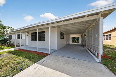
115 N 11th St Lantana, FL 33462
Lantana Heights NeighborhoodEstimated payment $2,671/month
Highlights
- Room in yard for a pool
- Porch
- Central Heating and Cooling System
- Breakfast Area or Nook
- Open Patio
- Combination Dining and Living Room
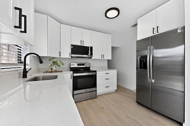
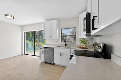
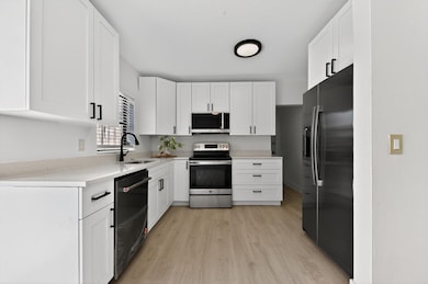
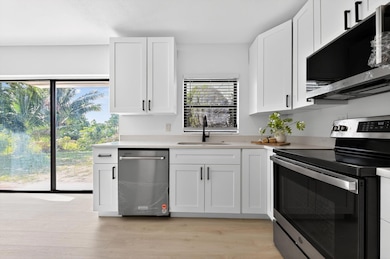
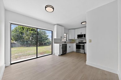
About This Home
Welcome to 115 N 11th St, a beautifully renovated home just minutes from the beach. This property has been fully remodeled from top to bottom, offering the perfect blend of modern comfort, style, and peace of mind. Step inside and fall in love with the brand-new shaker cabinets, quartz countertops, and stainless steel appliances that make the kitchen a true showpiece. The home also features a new roof, new A/C system, new water heater, new bathrooms, and luxury flooring throughout. Every corner shines with new lighting fixtures, fresh blinds, and high-quality finishes that make this home feel brand new. HUGE BACKYARD Outside, enjoy the charm of a quiet Lantana neighborhood just minutes from beaches, dining, and shopping. The perfect location for relaxed Florida living.

Home Details
Home Type
- Single Family
Est. Annual Taxes
- $5,221
Year Built
- Built in 1957
Lot Details
- 10,143 Sq Ft Lot
- East Facing Home
- Paved or Partially Paved Lot
- Property is zoned R3
Home Design
- Shingle Roof
- Composition Roof
Interior Spaces
- 1,200 Sq Ft Home
- 1-Story Property
- Ceiling Fan
- Combination Dining and Living Room
- Vinyl Flooring
- Fire and Smoke Detector
- Washer and Dryer Hookup
Kitchen
- Breakfast Area or Nook
- Electric Range
- Microwave
- Dishwasher
- Disposal
Bedrooms and Bathrooms
- 3 Main Level Bedrooms
Parking
- 2 Carport Spaces
- Driveway
Outdoor Features
- Room in yard for a pool
- Open Patio
- Porch
Schools
- Lantana Elementary School
- Lantana Community Middle School
- Santaluces Community High School
Utilities
- Central Heating and Cooling System
- Gas Water Heater
Community Details
- Lantana Heights 04 Subdivision
Listing and Financial Details
- Assessor Parcel Number 40434504070070100
Map
Home Values in the Area
Average Home Value in this Area
Tax History
| Year | Tax Paid | Tax Assessment Tax Assessment Total Assessment is a certain percentage of the fair market value that is determined by local assessors to be the total taxable value of land and additions on the property. | Land | Improvement |
|---|---|---|---|---|
| 2024 | $5,221 | $207,524 | -- | -- |
| 2023 | $4,837 | $188,658 | $0 | $0 |
| 2022 | $4,622 | $171,507 | $0 | $0 |
| 2021 | $4,073 | $212,190 | $123,758 | $88,432 |
| 2020 | $3,660 | $177,618 | $80,500 | $97,118 |
| 2019 | $3,486 | $173,498 | $77,000 | $96,498 |
| 2018 | $3,147 | $162,132 | $73,012 | $89,120 |
| 2017 | $2,834 | $143,177 | $63,488 | $79,689 |
| 2016 | $2,635 | $96,811 | $0 | $0 |
| 2015 | $2,471 | $88,010 | $0 | $0 |
| 2014 | $2,122 | $80,009 | $0 | $0 |
Property History
| Date | Event | Price | List to Sale | Price per Sq Ft |
|---|---|---|---|---|
| 11/11/2025 11/11/25 | For Sale | $424,990 | -- | $354 / Sq Ft |
Purchase History
| Date | Type | Sale Price | Title Company |
|---|---|---|---|
| Quit Claim Deed | -- | Mellinger Title Services | |
| Quit Claim Deed | -- | Mellinger Title Services | |
| Quit Claim Deed | -- | United Title Land Svcs Inc |
Source: BeachesMLS (Greater Fort Lauderdale)
MLS Number: F10536145
APN: 40-43-45-04-07-007-0100
Disclaimer: Certain information contained herein is derived from information provided by parties other than Homes.com. All information provided is deemed reliable, but is not guaranteed to be accurate and should be independently verified.
![]() All listings featuring the BMLS logo are provided by Beaches MLS, Inc. This information is not verified for authenticity or accuracy and is not guaranteed. Copyright 2025 Beaches Multiple Listing Service, Inc. Information is provided exclusively for consumers' personal, non-commercial use and may not be used for any purpose other than to identify prospective properties consumers may be interested in purchasing.
All listings featuring the BMLS logo are provided by Beaches MLS, Inc. This information is not verified for authenticity or accuracy and is not guaranteed. Copyright 2025 Beaches Multiple Listing Service, Inc. Information is provided exclusively for consumers' personal, non-commercial use and may not be used for any purpose other than to identify prospective properties consumers may be interested in purchasing.
- 806 Minnesota St
- 1014 W Broward St
- 1002 W Broome St
- 626 Minnesota St
- 907 W Bloxham St
- 527 S 13th Ct
- 702 S 12th St
- 516 S Arnold Ave
- 728 Ridge Rd Unit 35
- 708 S 12th St
- 420 W Palm St Unit A22
- 410 Minnesota St
- 410 W Palm St Unit B24
- 815 Andrew Redding Rd Unit 401
- 614 N 5th St
- 1307 Flamingo Dr
- 735 La Costa Way
- 826 Palama Way
- 803 Ridge Rd Unit 7
- 328 W Pine St Unit 22
- 1351 W Mango St Unit A
- 408 S 9th St
- 626 W Mango St Unit A
- 900 Water Tower Way
- 917 W Drew St
- 420 W Palm St Unit 4
- 420 W Palm St Unit A22
- 416 W Mango St Unit 416
- 414 W Mango St
- 525 S Broadway Unit N
- 525 S Broadway Unit C
- 714 S Arnold Ave Unit B
- 620 S Broadway Unit 9
- 607 W Perry St
- 334 Anderson Rd
- 700 S Broadway Unit 4
- 1032 W Jennings St
- 498 W Drew St Unit C
- 1006 S Arnold Ave
- 115 E Lantana Rd Unit 2