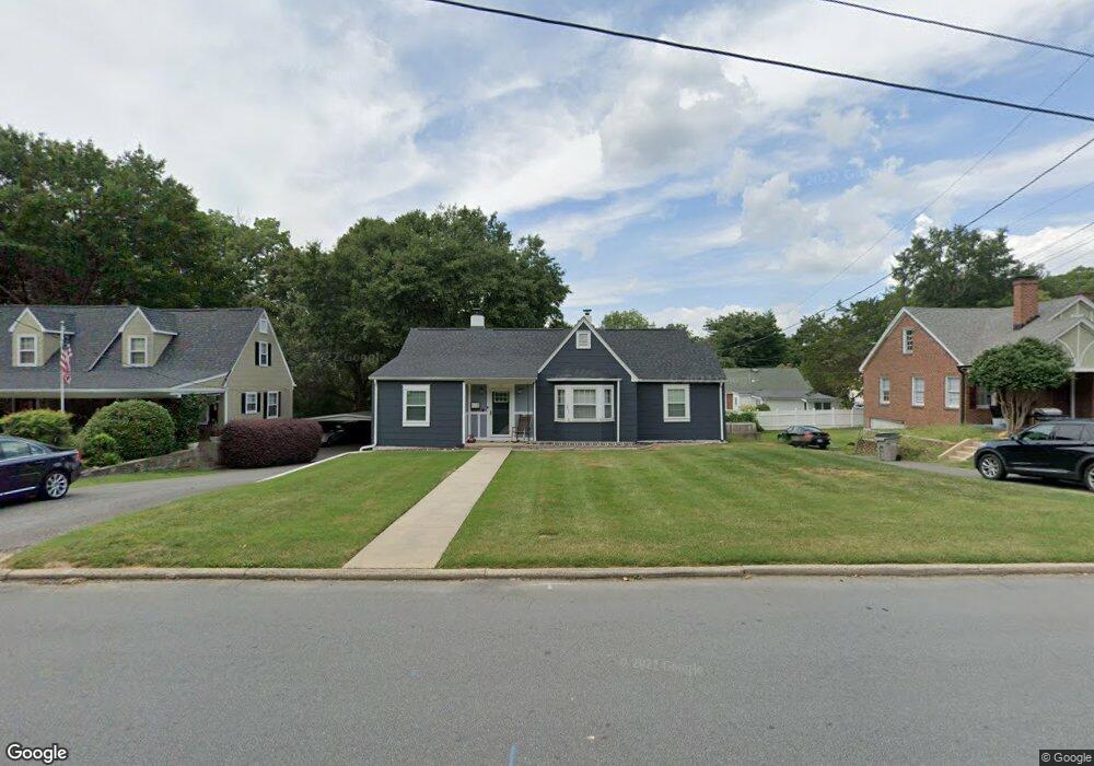
115 Patrick St Unit 12 Gastonia, NC 28054
Estimated Value: $220,828 - $244,000
3
Beds
2
Baths
1,497
Sq Ft
$155/Sq Ft
Est. Value
About This Home
This home is located at 115 Patrick St Unit 12, Gastonia, NC 28054 and is currently estimated at $232,707, approximately $155 per square foot. 115 Patrick St Unit 12 is a home located in Gaston County with nearby schools including Woodhill Elementary School, W P Grier Middle School, and Ashbrook High School.
Ownership History
Date
Name
Owned For
Owner Type
Purchase Details
Closed on
Dec 5, 2017
Sold by
Windley Walter H and Windley Betty E
Bought by
Brack Abigail Faith
Current Estimated Value
Home Financials for this Owner
Home Financials are based on the most recent Mortgage that was taken out on this home.
Original Mortgage
$132,000
Outstanding Balance
$113,025
Interest Rate
4.62%
Mortgage Type
Adjustable Rate Mortgage/ARM
Estimated Equity
$119,682
Purchase Details
Closed on
Jan 31, 2011
Sold by
Windley Walter H and Windley Betty E
Bought by
The Windley Family Trust
Create a Home Valuation Report for This Property
The Home Valuation Report is an in-depth analysis detailing your home's value as well as a comparison with similar homes in the area
Home Values in the Area
Average Home Value in this Area
Purchase History
| Date | Buyer | Sale Price | Title Company |
|---|---|---|---|
| Brack Abigail Faith | $132,000 | None Available | |
| The Windley Family Trust | -- | None Available |
Source: Public Records
Mortgage History
| Date | Status | Borrower | Loan Amount |
|---|---|---|---|
| Open | Brack Abigail Faith | $132,000 |
Source: Public Records
Tax History
| Year | Tax Paid | Tax Assessment Tax Assessment Total Assessment is a certain percentage of the fair market value that is determined by local assessors to be the total taxable value of land and additions on the property. | Land | Improvement |
|---|---|---|---|---|
| 2025 | $1,929 | $180,410 | $19,000 | $161,410 |
| 2024 | $1,929 | $180,410 | $19,000 | $161,410 |
| 2023 | $1,948 | $180,410 | $19,000 | $161,410 |
| 2022 | $1,602 | $120,470 | $14,000 | $106,470 |
| 2021 | $1,626 | $120,470 | $14,000 | $106,470 |
| 2019 | $1,638 | $120,470 | $14,000 | $106,470 |
| 2018 | $1,413 | $100,901 | $16,800 | $84,101 |
| 2017 | $1,413 | $100,901 | $16,800 | $84,101 |
| 2016 | $1,413 | $100,901 | $0 | $0 |
| 2014 | $1,373 | $98,106 | $21,000 | $77,106 |
Source: Public Records
Map
Nearby Homes
- 120 N Belvedere Ave
- 109 N Belvedere Ave
- 1021 E Airline Ave
- 1009 E Airline Ave
- 722 E Airline Ave
- 1212 E Franklin Blvd Unit D
- 949 E Long Ave
- 1111 E Park Dr
- 117 Oakdale St
- 815 E Second Ave
- 1222 E Park Dr
- 1537 Poston Cir
- 1107 Fairfield Dr
- 408 Elizabeth St
- 505 N Chestnut St
- 614 N Rhyne St
- 1627 Warren Ave
- 907 E 4th Ave
- 1605 Fairfield Dr
- 626 E 4th Ave
- 115 Patrick St
- 117 Patrick St
- 113 Patrick St
- 110 N Belvedere Ave
- 108 N Belvedere Ave
- 119 Patrick St
- 111 Patrick St
- 112 N Belvedere Ave
- 106 N Belvedere Ave
- 120 Patrick St
- 104 N Belvedere Ave
- 121 Patrick St Unit 1/2
- 121 Patrick St
- 116 Patrick St
- 116 N Belvedere Ave
- 102 N Belvedere Ave
- 122 Patrick St
- 118 N Belvedere Ave
- 110 Patrick St
- 123 Patrick St
Your Personal Tour Guide
Ask me questions while you tour the home.