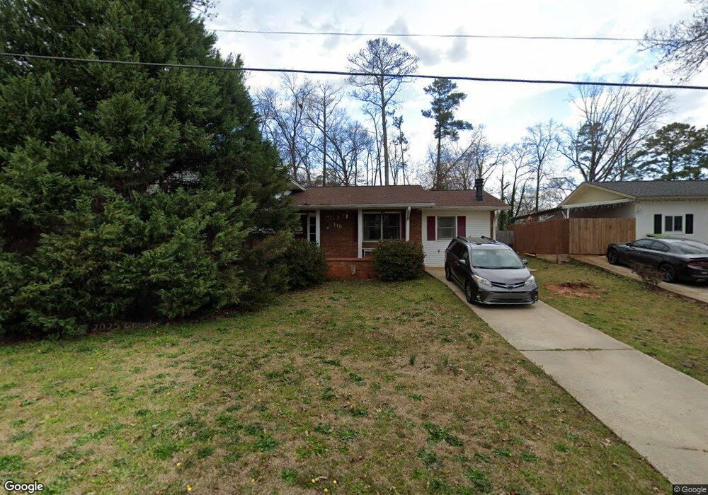
115 Pinedale Dr Warner Robins, GA 31088
Estimated Value: $188,000 - $214,000
--
Bed
1
Bath
2,114
Sq Ft
$96/Sq Ft
Est. Value
About This Home
This home is located at 115 Pinedale Dr, Warner Robins, GA 31088 and is currently estimated at $203,798, approximately $96 per square foot. 115 Pinedale Dr is a home located in Houston County with nearby schools including Shirley Hills Elementary School, Warner Robins Middle School, and Warner Robins High School.
Ownership History
Date
Name
Owned For
Owner Type
Purchase Details
Closed on
Mar 30, 1988
Sold by
Cooke Walter R and Cooke Geraldine
Bought by
Hopf Michael T and Melinda A*
Current Estimated Value
Purchase Details
Closed on
May 20, 1982
Sold by
Elliott Richard W and Elliott Melanie
Bought by
Cooke Walter R and Geraldine B*
Purchase Details
Closed on
Aug 1, 1977
Sold by
Wendt Frankie I and Wendt William F
Bought by
Elliott Richard W and Elliott Melanie L
Purchase Details
Closed on
Jun 21, 1965
Bought by
Wendt Frankie I and Wendt William F
Create a Home Valuation Report for This Property
The Home Valuation Report is an in-depth analysis detailing your home's value as well as a comparison with similar homes in the area
Home Values in the Area
Average Home Value in this Area
Purchase History
| Date | Buyer | Sale Price | Title Company |
|---|---|---|---|
| Hopf Michael T | -- | -- | |
| Cooke Walter R | -- | -- | |
| Elliott Richard W | -- | -- | |
| Wendt Frankie I | -- | -- |
Source: Public Records
Tax History Compared to Growth
Tax History
| Year | Tax Paid | Tax Assessment Tax Assessment Total Assessment is a certain percentage of the fair market value that is determined by local assessors to be the total taxable value of land and additions on the property. | Land | Improvement |
|---|---|---|---|---|
| 2024 | $1,947 | $60,880 | $6,600 | $54,280 |
| 2023 | $1,801 | $56,000 | $6,600 | $49,400 |
| 2022 | $1,149 | $51,960 | $6,600 | $45,360 |
| 2021 | $1,005 | $45,480 | $5,280 | $40,200 |
| 2020 | $971 | $43,800 | $5,280 | $38,520 |
| 2019 | $971 | $43,800 | $5,280 | $38,520 |
| 2018 | $971 | $43,800 | $5,280 | $38,520 |
| 2017 | $972 | $43,800 | $5,280 | $38,520 |
| 2016 | $974 | $43,800 | $5,280 | $38,520 |
| 2015 | -- | $43,800 | $5,280 | $38,520 |
| 2014 | -- | $43,800 | $5,280 | $38,520 |
| 2013 | -- | $43,800 | $5,280 | $38,520 |
Source: Public Records
Map
Nearby Homes
- 139 Rolling Woods Cir
- 103 Oakdale Dr
- 1000 Corder Rd
- 108 Woodsdale Dr
- 115 Glendale Ct
- 103 Victor St
- 305 Tarrasa Dr
- 1850 Russell Pkwy
- 0 Russell Pkwy Unit 10656199
- 107 Via Eldorado Dr
- 304 Laurie Ln
- 216 Self St
- 213 Self St
- 201 Belmont Dr
- 100 Glenwood Ave Unit 701 S. Houston Lake
- 100 Glenwood Ave
- 105 Maga Ct
- 100 Belmont Dr
- 111 Glenwood Ave
- 118 Fox Glove Ct
- 113 Pinedale Dr
- 111 Pinedale Dr
- 101 Sunnydale Dr
- 109 Pinedale Dr
- 108 Georgia Dean St
- 100 Sunnydale Dr
- 103 Sunnydale Dr
- 108 Trusty Trail
- 100 Trusty Trail Unit 5C
- 143 Rolling Woods Cir
- 102 Sunnydale Dr
- 112 Pinedale Dr
- 107 Pinedale Dr
- 137 Rolling Woods Cir
- 105 Sunnydale Dr
- 110 Pinedale Dr
- 147 Rolling Woods Cir
- 115 Oakdale Dr
- 105 Pinedale Dr
- 108 Pinedale Dr