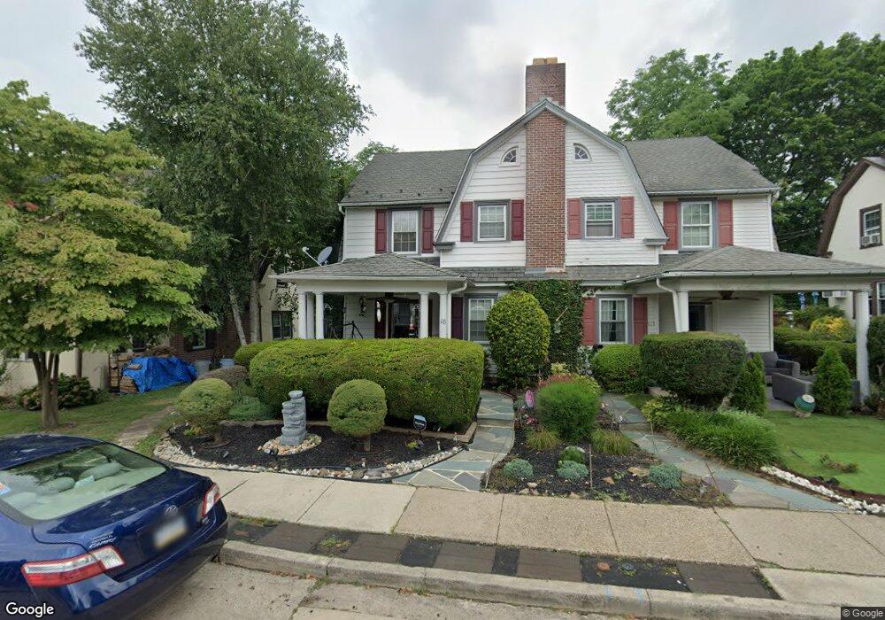
115 Walsh Rd Lansdowne, PA 19050
Estimated Value: $306,507 - $358,000
4
Beds
2
Baths
1,716
Sq Ft
$195/Sq Ft
Est. Value
About This Home
This home is located at 115 Walsh Rd, Lansdowne, PA 19050 and is currently estimated at $334,877, approximately $195 per square foot. 115 Walsh Rd is a home located in Delaware County with nearby schools including Ardmore Avenue School, Penn Wood Middle School, and Penn Wood High School - Cypress Street Campus.
Ownership History
Date
Name
Owned For
Owner Type
Purchase Details
Closed on
Sep 28, 1999
Sold by
Chase Manhattan Bank
Bought by
Wright Martin
Current Estimated Value
Home Financials for this Owner
Home Financials are based on the most recent Mortgage that was taken out on this home.
Original Mortgage
$63,000
Outstanding Balance
$19,633
Interest Rate
8.25%
Estimated Equity
$315,244
Purchase Details
Closed on
Nov 9, 1998
Sold by
Coleman Melvin P
Bought by
Access Financial Mtg Loan Trust 1996-4
Purchase Details
Closed on
Sep 20, 1996
Sold by
Payne Kennie F
Bought by
Coleman Melvin P
Home Financials for this Owner
Home Financials are based on the most recent Mortgage that was taken out on this home.
Original Mortgage
$84,750
Interest Rate
10.24%
Mortgage Type
Balloon
Create a Home Valuation Report for This Property
The Home Valuation Report is an in-depth analysis detailing your home's value as well as a comparison with similar homes in the area
Home Values in the Area
Average Home Value in this Area
Purchase History
| Date | Buyer | Sale Price | Title Company |
|---|---|---|---|
| Wright Martin | $70,000 | -- | |
| Access Financial Mtg Loan Trust 1996-4 | -- | -- | |
| Coleman Melvin P | $113,000 | -- |
Source: Public Records
Mortgage History
| Date | Status | Borrower | Loan Amount |
|---|---|---|---|
| Open | Wright Martin | $63,000 | |
| Previous Owner | Coleman Melvin P | $84,750 | |
| Closed | Coleman Melvin P | $28,250 |
Source: Public Records
Tax History
| Year | Tax Paid | Tax Assessment Tax Assessment Total Assessment is a certain percentage of the fair market value that is determined by local assessors to be the total taxable value of land and additions on the property. | Land | Improvement |
|---|---|---|---|---|
| 2025 | $6,691 | $162,520 | $48,740 | $113,780 |
| 2024 | $6,691 | $162,520 | $48,740 | $113,780 |
| 2023 | $6,379 | $162,520 | $48,740 | $113,780 |
| 2022 | $6,254 | $162,520 | $48,740 | $113,780 |
| 2021 | $9,392 | $162,520 | $48,740 | $113,780 |
| 2020 | $6,314 | $96,280 | $26,830 | $69,450 |
| 2019 | $6,208 | $96,280 | $26,830 | $69,450 |
| 2018 | $6,102 | $96,280 | $0 | $0 |
| 2017 | $5,967 | $96,280 | $0 | $0 |
| 2016 | $528 | $96,280 | $0 | $0 |
| 2015 | $528 | $96,280 | $0 | $0 |
| 2014 | $528 | $96,280 | $0 | $0 |
Source: Public Records
Map
Nearby Homes
- 233 Scottdale Rd
- 53 Eldon Ave
- 65 Eldon Ave
- 120 Abbey Terrace
- 257 W Greenwood Ave
- 82 Marple Ave
- 3825 Dennison Ave
- 442 E Baltimore Ave
- 3822 James St
- 164 Abbey Terrace
- 85 Bridge St
- 80 W Baltimore Ave Unit C607
- 80 W Baltimore Ave Unit B607
- 29 Roselawn Ave
- 3941 Bridge St
- 162 Burmont Rd
- 222 Holly St
- 242 Shadeland Ave
- 220 Birchwood Rd
- 3854 Ann St
Your Personal Tour Guide
Ask me questions while you tour the home.