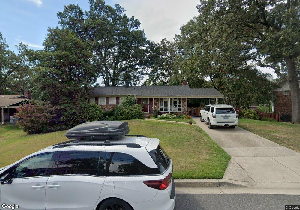
11508 Nevis Dr Beltsville, MD 20705
Estimated Value: $386,083 - $557,000
--
Bed
2
Baths
1,204
Sq Ft
$408/Sq Ft
Est. Value
About This Home
This home is located at 11508 Nevis Dr, Beltsville, MD 20705 and is currently estimated at $491,021, approximately $407 per square foot. 11508 Nevis Dr is a home located in Prince George's County with nearby schools including Calverton Elementary School, Martin Luther King Jr. Middle School, and High Point High School.
Ownership History
Date
Name
Owned For
Owner Type
Purchase Details
Closed on
Aug 3, 2012
Sold by
Millard Alfred Woodrow
Bought by
Millard Alfred Woodrow and Orth Diane Susan
Current Estimated Value
Purchase Details
Closed on
Oct 4, 1995
Sold by
Arhar Joseph F
Bought by
Millard Alfred W
Home Financials for this Owner
Home Financials are based on the most recent Mortgage that was taken out on this home.
Original Mortgage
$155,000
Interest Rate
7.86%
Create a Home Valuation Report for This Property
The Home Valuation Report is an in-depth analysis detailing your home's value as well as a comparison with similar homes in the area
Home Values in the Area
Average Home Value in this Area
Purchase History
| Date | Buyer | Sale Price | Title Company |
|---|---|---|---|
| Millard Alfred Woodrow | -- | Consumer Real Estate Title I | |
| Millard Alfred W | $155,000 | -- |
Source: Public Records
Mortgage History
| Date | Status | Borrower | Loan Amount |
|---|---|---|---|
| Closed | Millard Alfred W | $155,000 |
Source: Public Records
Tax History Compared to Growth
Tax History
| Year | Tax Paid | Tax Assessment Tax Assessment Total Assessment is a certain percentage of the fair market value that is determined by local assessors to be the total taxable value of land and additions on the property. | Land | Improvement |
|---|---|---|---|---|
| 2025 | $4,327 | $370,000 | $126,500 | $243,500 |
| 2024 | $4,327 | $339,533 | $0 | $0 |
| 2023 | $4,110 | $309,067 | $0 | $0 |
| 2022 | $3,867 | $278,600 | $101,500 | $177,100 |
| 2021 | $3,751 | $275,300 | $0 | $0 |
| 2020 | $3,715 | $272,000 | $0 | $0 |
| 2019 | $3,660 | $268,700 | $75,700 | $193,000 |
| 2018 | $3,591 | $266,233 | $0 | $0 |
| 2017 | $3,541 | $263,767 | $0 | $0 |
| 2016 | -- | $261,300 | $0 | $0 |
| 2015 | $2,861 | $238,667 | $0 | $0 |
| 2014 | $2,861 | $216,033 | $0 | $0 |
Source: Public Records
Map
Nearby Homes
- 3311 Major Denton Dr
- 3702 Evans Trail Way
- 11312 Cherry Hill Rd Unit 2YOU
- 0 Powder Mill Rd Unit MDPG2130944
- 0 Powder Mill Rd Unit MDPG2130948
- 11342 Cherry Hill Rd Unit 2-E101
- 11316 Cherry Hill Rd Unit 203
- 11204 Cherry Hill Rd Unit T2
- 11206 Cherry Hill Rd Unit T2
- 11240 Cherry Hill Rd Unit 21
- 11242 Cherry Hill Rd Unit T1
- 12014 Swallow Falls Ct
- 2909 Chapel View Dr
- 11216 Cherry Hill Rd Unit 304
- 11230 Cherry Hill Rd
- 11220 Cherry Hill Rd
- 27 Hunters Gate Ct
- 3707 Green Ash Ct
- 2724 Hunters Gate Terrace
- 3311 Powder Mill Rd
- 11510 Nevis Dr
- 11506 Nevis Dr
- 3606 Pocono Place
- 3604 Pocono Place
- 3608 Pocono Place
- 11511 Nevis Dr
- 11509 Nevis Dr
- 11504 Nevis Dr
- 3602 Pocono Place
- 11512 Nevis Dr
- 3610 Pocono Place
- 11513 Nevis Dr
- 11507 Nevis Dr
- 3612 Pocono Place
- 3600 Pocono Place
- 11502 Nevis Dr
- 11505 Nevis Dr
- 3614 Pocono Place
- 11508 Blueridge Dr
- 11510 Blueridge Dr