$70,187
SOLD JUN 25, 2025

11509 E Autio Rd Maple, WI 54854

4.77 Acres
$14,714 Price per Acre
207,781 Sq Ft Lot

Recently Sold

28% Above List Price

4 Days on Market

Highlights

  • Panoramic View
  • No HOA
  • Landscaped with Trees
  • Outdoor Water Feature
  • 2 Acres of Pasture
  • High Speed Internet

About This Lot

As of June 2025

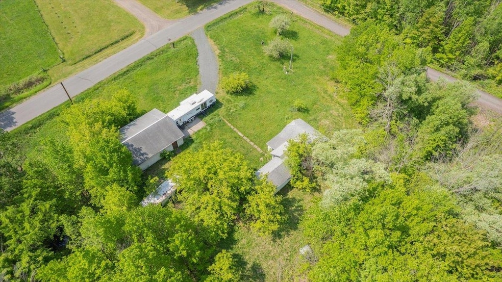
Google meaning of Autio rd and here is what you will get. Finnish: topographic name from autio 'uninhabited, abandoned', denoting a farm or field that had fallen into disuse. In northern Finland the word means 'spacious, wide' and is a frequent placename; there are also farms so named in eastern areas, which gave rise to the surname. Why write an ad that says anything more, except, this place has way more than meets the eye! There is a structure... yes, it is in disrepair. Maybe you can save it. The cost of building is crazy high and you have something to work with and that should reduce your costs. Is there some debris... yes. You might find some treasures. Think of it as a treasure hunt! Is it uninhabited? yes, but these days people like privacy. Things are getting busier and more crowded, this place offers you 4.77 acres of space with trees, and pasture and wildlife and that is just the beginning. There is a decent garage with a concrete floor, there is also a well! Wells cost around $25k these days, and this is almost half the value of what you are buying! There is a nice gravel driveway, and driveways cost around $100 per foot, so there is some good value there as well. The land is beautiful with some neighbors, but they are not on top of you. The views are panoramic and yet the trees provide a level of privacy. And there is a camper that the buyer can have with the purchase of this property too! The meaning of the road name meets this description well. Come make this your next adventure!

Last Agent to Sell the Property

Leah Hollenbach

RE/MAX Results Listed on: 06/03/2025

RE/MAX Results

Last Buyer's Agent

Tom Acton

RE/MAX Results

RE/MAX Results

Property Details

Property Type

  • Land

Est. Annual Taxes

  • $818

Lot Details

  • 4.77 Acre Lot
  • Lot Dimensions are 330x630
  • Property fronts a county road
  • Level Lot
  • Irrigation
  • Landscaped with Trees

Property Views

  • Panoramic Views

Parking

  • Gravel Driveway
  • Off-Street Parking

Farming

  • Tillable Land
  • 2 Acres of Pasture

Utilities

  • Private Company Owned Well
  • High Speed Internet
  • Satellite Dish

Community Details

Overview

  • No Home Owners Association

Recreation

  • Outdoor Water Feature

Property Details

Property Type

Land

Est. Annual Taxes

$818

Lot Details

0

Listing Details

  • Estimated Pasture Acres: 2
  • Estimated Wooded Acres: 1.77
  • Class: LOT/LAND
  • Senior Community: No
  • Directions: From hwy 2, North on F, right on Autio Rd, property is on your left.
  • InternetOptions: DSL, Satellite
  • Waterfront Info Lake Chain: No
  • L O1 Office Phone1 Number: 218-310-8859
  • Renewal Options: Sell Entirely
  • Planned Unit Development: No
  • New Development Plat Recorded: No
  • List Price/ Sq Ft: 14714.26
  • PropAdjoinsPublicLand: No
  • Road Maintenance: Public
  • Property Sub-Type: Residential
  • Tax Year: 2024
  • Twp Number: 48N
  • View Type:Pond View: Panoramic, Typical
  • Lot Description Waterfront: No
  • Special Features: None
  • Property Sub Type: LotsLands

Exterior Features

  • Out Buildings: Other Bldngs
  • Road Frontage: Paved, County

Garage/Parking

  • Parking Driveway: Driveway - Gravel, Off Street

Utilities

  • Available Utilities: Electric, Private Well
  • On Site Utilities: Electric, Private Well
  • Power Company: East Central Energy

Condo/Co-op/Association

  • Association Fee: No

Schools

  • School District: Maple (WI) #3297
  • Junior High Dist: Maple (WI) #3297

Lot Info

  • Geo Update Timestamp: 2025-06-05
  • Estimated Lot Dimensions: 330x630
  • Estimated Number of Acres: 4.77
  • Cultivated Acreage: LSAR
  • Builder Restrictions: None
  • Geo Subdivision: WI
  • Improvements: Water Feature, Watering System
  • Land Improvements: Yes
  • Lot Description: Tillable, Tree Coverage - Medium, Level, Rolling, See Remarks

Rental Info

  • Lease Terms: Cash, Conventional

Tax Info

  • Tax Amount: 817.89

Ownership History

Date Name Owned For Owner Type

Purchase Details

Closed on
Dec 15, 2022
Sold by
Douglas County
Bought by
Mayne Jeffrey

Purchase Details

Closed on
Jun 20, 2022
Sold by
Lukkarila Michael E
Bought by
Douglas County

Purchase Details

Closed on
Jun 4, 2012
Sold by
Sharp Amelia S
Bought by
Lukkarila Michael E
Source: Public Records

Range of Values:

Collateral Analytics

Collateral Analytics Collateral Analytics AVMs (Automated Valuation Model) employ a number of statistical approaches combined with neighborhood-specific comparable selection guarantees the most up-to-date and precise valuations.

Not Available

Collateral Analytics does not have data for the current month. Please view the chart for historical values.

ICE

ICE Mortgage Technology ICE Mortgage Technology’s AVM (Automated Valuation Model) is a state-of-the-art online residential property valuation tool that provides a quick and accurate estimate of the value of almost any home in the U.S.

Not Available

ICE Mortgage Technology does not have data for the current month. Please view the chart for historical values.

First American

First American First American Data & Analytics’ next-generation AVM combines unrivaled data assets with a blended ensemble of valuation models to produce highly accurate, reliable valuations you can trust.

Not Available

First American does not have data for the current month. Please view the chart for historical values.

Quantarium

Quantarium Quantarium’s valuation service, repeatedly proven the industry’s most accurate and comprehensive, is supercharged with a self-learning and auto-tuning AI engine that continually becomes smarter and more accurate as it processes daily inputs from the industry’s leading RE data lake.

Not Available

Quantarium does not have data for the current month. Please view the chart for historical values.

Average Value
Not Available
List Price
Sold Price
Create a Home Valuation Report for This Property
The Home Valuation Report is an in-depth analysis detailing your home's value as well as a comparison with similar homes in the area

Home Values in the Area

Source: Public Records

Average Home Value in this Area


Source: Public Records

Purchase History

Date Type Sale Price Title Company
Quit Claim Deed $16,501 Cheryl Westman
Quit Claim Deed $38,600 Amanda Johnson
Quit Claim Deed $30,000 --
Source: Public Records

Property History

Date Event Price Change Sq Ft Price
06/25/2025 06/25/25 Sold $70,187 +27.6% --
06/07/2025 06/07/25 Pending -- -- --
06/03/2025 06/03/25 For Sale $55,000 -- --
Source: Lake Superior Area REALTORS®

Tax History Compared to Growth

Source: Public Records

Tax History

Year Tax Paid Tax Assessment Tax Assessment Total Assessment is a certain percentage of the fair market value that is determined by local assessors to be the total taxable value of land and additions on the property. Land Improvement
2024 $818 $38,900 $6,000 $32,900
2023 $717 $38,900 $6,000 $32,900
2022 $653 $39,000 $6,100 $32,900
2021 $626 $39,000 $6,100 $32,900
2020 $658 $39,000 $6,100 $32,900
2019 $656 $39,000 $6,100 $32,900
2018 $675 $39,000 $6,100 $32,900
2017 $697 $39,000 $6,100 $32,900
2016 $721 $39,000 $6,100 $32,900
2015 $693 $33,000 $9,500 $33,000
2014 $693 $42,500 $9,500 $33,000
2013 $684 $42,500 $9,500 $33,000
Source: Public Records

Agents Affiliated with this Home

  • Section Image
  • Section Image
See All Agents

Map

Source: Lake Superior Area REALTORS®

MLS Number: 6119850

APN: MA-020-00541-01