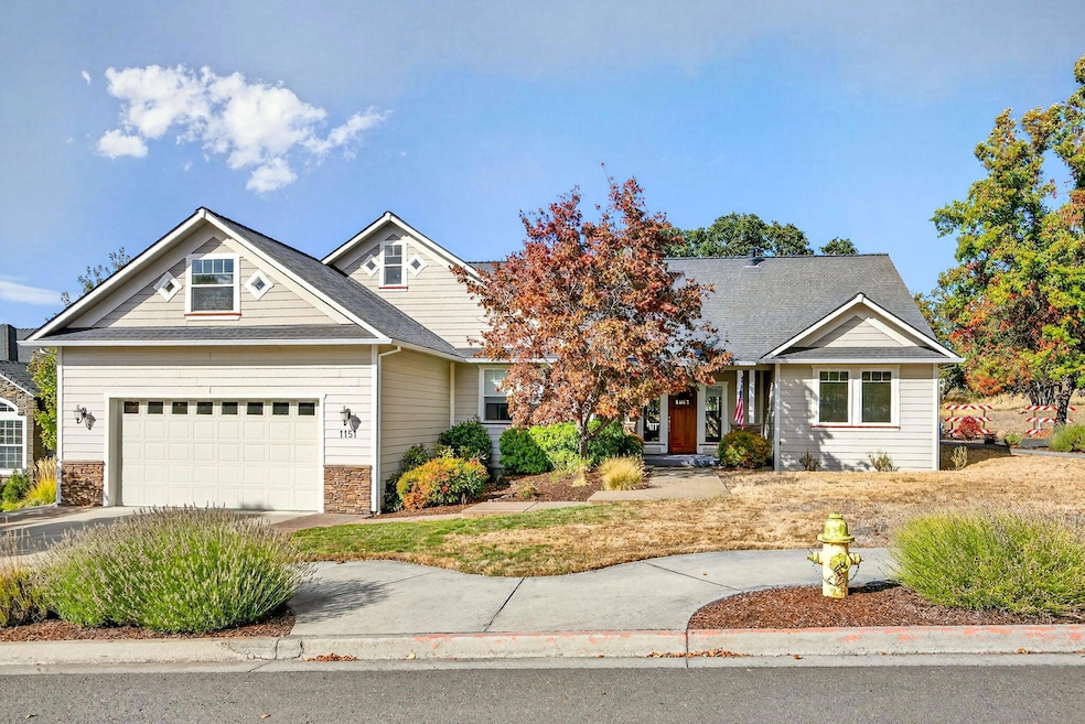
1151 Arrowhead Trail Eagle Point, OR 97524
Estimated payment $3,009/month
Highlights
- Golf Course Community
- Contemporary Architecture
- Corner Lot
- Mountain View
- Vaulted Ceiling
- Granite Countertops
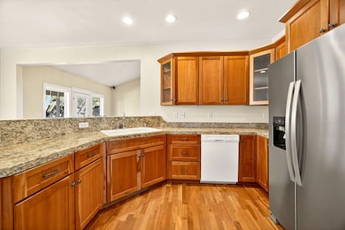
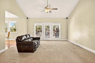
About This Home
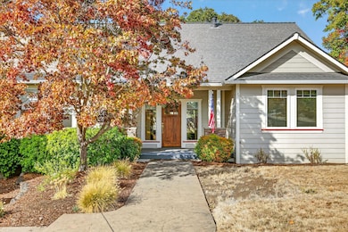
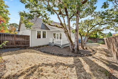
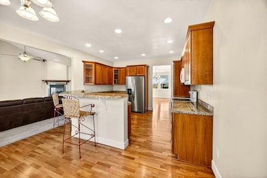
Situated on a desirable corner lot in the Eagle Point Golf Course community, this spacious home blends timeless design w/fantastic potential. Featuring wood & travertine floors, high ceilings, & large windows that fill the space w/natural light, it offers an inviting great room w/cozy gas fireplace, a generous formal dining room, and a breakfast nook off the well-appointed kitchen w/granite counters & cherry cabinetry. The primary suite is a true retreat w/coffered ceilings, a jetted soaking tub, walk-in double shower, & private deck, while two additional bedrooms and a full bath are thoughtfully positioned on the opposite side of the split floor plan. A large bonus room upstairs provides endless possibilities for a media room, home gym, or additional living space, & the oversized garage, central vacuum, & mature landscaping add convenience and charm. With lovely views of the Table Rock Mountains & plenty of room to personalize, this home is ready for its next chapter.
Listing Agent
John L. Scott Ashland Brokerage Phone: 5418218284 License #200604146 Listed on: 10/16/2025

Home Details
Home Type
- Single Family
Est. Annual Taxes
- $5,506
Year Built
- Built in 2003
Lot Details
- 9,148 Sq Ft Lot
- Fenced
- Corner Lot
- Zoning described as R-1-8
HOA Fees
- $15 Monthly HOA Fees
Parking
- 2 Car Garage
- Garage Door Opener
- Driveway
- On-Street Parking
Property Views
- Mountain
- Territorial
- Neighborhood
Home Design
- Contemporary Architecture
- Slab Foundation
- Composition Roof
Interior Spaces
- 2,526 Sq Ft Home
- 2-Story Property
- Vaulted Ceiling
- Ceiling Fan
- Gas Fireplace
- Double Pane Windows
- Vinyl Clad Windows
- Living Room with Fireplace
Kitchen
- Breakfast Area or Nook
- Breakfast Bar
- Oven
- Cooktop
- Microwave
- Dishwasher
- Granite Countertops
- Tile Countertops
- Disposal
Flooring
- Carpet
- Laminate
- Tile
Bedrooms and Bathrooms
- 3 Bedrooms
- Linen Closet
- Walk-In Closet
- Double Vanity
- Soaking Tub
- Bathtub with Shower
Laundry
- Dryer
- Washer
Home Security
- Carbon Monoxide Detectors
- Fire and Smoke Detector
Outdoor Features
- Covered Deck
- Rear Porch
Schools
- Hillside Elementary School
- Eagle Point Middle School
- Eagle Point High School
Utilities
- Forced Air Heating and Cooling System
- Water Heater
Listing and Financial Details
- Tax Lot 2200
- Assessor Parcel Number 10975560
Community Details
Overview
- Hillsborough Estates Subdivision
- On-Site Maintenance
Recreation
- Golf Course Community
Map
Home Values in the Area
Average Home Value in this Area
Tax History
| Year | Tax Paid | Tax Assessment Tax Assessment Total Assessment is a certain percentage of the fair market value that is determined by local assessors to be the total taxable value of land and additions on the property. | Land | Improvement |
|---|---|---|---|---|
| 2026 | $5,506 | $389,590 | $126,000 | $263,590 |
| 2025 | $5,376 | $392,860 | $94,460 | $298,400 |
| 2024 | $5,376 | $381,420 | $91,710 | $289,710 |
| 2023 | $5,193 | $370,320 | $89,040 | $281,280 |
| 2022 | $5,052 | $370,320 | $89,040 | $281,280 |
| 2021 | $4,902 | $359,540 | $86,440 | $273,100 |
| 2020 | $5,208 | $349,070 | $83,930 | $265,140 |
| 2019 | $5,128 | $329,040 | $79,120 | $249,920 |
| 2018 | $5,030 | $319,460 | $76,810 | $242,650 |
| 2017 | $4,907 | $319,460 | $76,810 | $242,650 |
| 2016 | $4,811 | $301,130 | $72,400 | $228,730 |
| 2015 | $4,654 | $301,130 | $72,400 | $228,730 |
| 2014 | $4,521 | $283,850 | $68,240 | $215,610 |
Property History
| Date | Event | Price | List to Sale | Price per Sq Ft |
|---|---|---|---|---|
| 03/30/2026 03/30/26 | Pending | -- | -- | -- |
| 10/29/2025 10/29/25 | Price Changed | $475,000 | -5.0% | $188 / Sq Ft |
| 10/16/2025 10/16/25 | For Sale | $500,000 | -- | $198 / Sq Ft |
Purchase History
| Date | Type | Sale Price | Title Company |
|---|---|---|---|
| Interfamily Deed Transfer | -- | None Available | |
| Warranty Deed | $365,000 | Lawyers Title Ins |
Mortgage History
| Date | Status | Loan Amount | Loan Type |
|---|---|---|---|
| Open | $255,450 | Purchase Money Mortgage | |
| Closed | $109,550 | No Value Available |
Source: Oregon Datashare
MLS Number: 220210703
APN: 10975560
Disclaimer: Certain information contained herein is derived from information provided by parties other than Homes.com. All information provided is deemed reliable, but is not guaranteed to be accurate and should be independently verified.
![]() © 2026 Oregon Datashare (KCAR | MLSCO | SOMLS). All rights reserved. The data relating to real estate for sale on this web site comes in part from the Internet Data Exchange Program of the Oregon Datashare. Real estate listings held by IDX Brokerage firms other than Ten-X are marked with the Internet Data Exchange logo or the Internet Data Exchange thumbnail logo and detailed information about them includes the name of the listing Brokers. Information provided is for consumers' personal, non-commercial use and may not be used for any purpose other than to identify prospective properties the viewer may be interested in purchasing. The consumer will not copy, retransmit nor redistribute any of the content from this website. Information provided is deemed reliable, but not guaranteed.
© 2026 Oregon Datashare (KCAR | MLSCO | SOMLS). All rights reserved. The data relating to real estate for sale on this web site comes in part from the Internet Data Exchange Program of the Oregon Datashare. Real estate listings held by IDX Brokerage firms other than Ten-X are marked with the Internet Data Exchange logo or the Internet Data Exchange thumbnail logo and detailed information about them includes the name of the listing Brokers. Information provided is for consumers' personal, non-commercial use and may not be used for any purpose other than to identify prospective properties the viewer may be interested in purchasing. The consumer will not copy, retransmit nor redistribute any of the content from this website. Information provided is deemed reliable, but not guaranteed.
- 374 Leandra Ln
- 1050 Azure Way
- 1135 Pumpkin Ridge Unit 319
- 1141 Pumpkin Ridge Unit 320
- 1043 Arrowhead Trail
- 1147 Pumpkin Unit 321
- 1140 Pumpkin Ridge Unit 336
- 1146 Pumpkin Unit 335
- 74 Eagle View Dr
- 1152 Pumpkin Unit 334
- 21 Cerulean Terrace
- 1159 Pumpkin Ridge Unit 323
- 1153 Pumpkin Unit 322
- 1164 Pumpkin Unit 332
- 384 Robert Trent Jones Blvd
- 997 Arrowhead Trail
- 218 Cambridge Terrace
- 995 Pumpkin Ridge
- 421 Stevens Rd Unit 20
- 421 Stevens Rd Unit 14
Ask me questions while you tour the home.