Estimated Value: $279,774 - $489,000
5
Beds
2
Baths
3,112
Sq Ft
$120/Sq Ft
Est. Value
About This Home
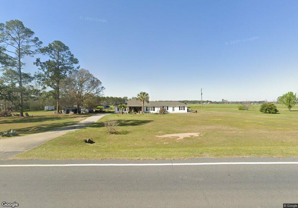
This home is located at 11511 Highway 76, Adel, GA 31620 and is currently estimated at $374,944, approximately $120 per square foot. 11511 Highway 76 is a home located in Cook County with nearby schools including Cook Primary School, Cook Elementary School, and Cook County Middle School.
Ownership History
Date
Name
Owned For
Owner Type
Purchase Details
Closed on
Aug 11, 2014
Sold by
Nunez Hector Jose
Bought by
Nunez Ana Carla
Current Estimated Value
Purchase Details
Closed on
Dec 30, 2011
Sold by
Gaskins Renee
Bought by
Nunez Hector Jose
Purchase Details
Closed on
Jul 29, 2011
Sold by
Burwell Management Group Llc
Bought by
Gaskins Renee
Purchase Details
Closed on
May 27, 2011
Sold by
The Bank Of New York Mellon
Bought by
Burwell Management Group Llc
Purchase Details
Closed on
Mar 2, 2010
Sold by
Woods Lori L
Bought by
The Bank Of New York Mellon
Purchase Details
Closed on
Apr 29, 2005
Sold by
Barber Tommy
Bought by
Woods Lori L
Create a Home Valuation Report for This Property
The Home Valuation Report is an in-depth analysis detailing your home's value as well as a comparison with similar homes in the area
Home Values in the Area
Average Home Value in this Area
Purchase History
| Date | Buyer | Sale Price | Title Company |
|---|---|---|---|
| Nunez Ana Carla | -- | -- | |
| Nunez Hector Jose | $129,000 | -- | |
| Gaskins Renee | $35,000 | -- | |
| Burwell Management Group Llc | $10,000 | -- | |
| The Bank Of New York Mellon | $128,848 | -- | |
| Woods Lori L | $27,000 | -- |
Source: Public Records
Tax History Compared to Growth
Tax History
| Year | Tax Paid | Tax Assessment Tax Assessment Total Assessment is a certain percentage of the fair market value that is determined by local assessors to be the total taxable value of land and additions on the property. | Land | Improvement |
|---|---|---|---|---|
| 2024 | $2,147 | $79,722 | $6,180 | $73,542 |
| 2023 | $1,857 | $68,936 | $6,180 | $62,756 |
| 2022 | $1,839 | $68,274 | $5,518 | $62,756 |
| 2021 | $1,620 | $56,098 | $5,518 | $50,580 |
| 2020 | $1,620 | $56,098 | $5,518 | $50,580 |
| 2019 | $1,621 | $56,098 | $5,518 | $50,580 |
| 2018 | $1,622 | $56,098 | $5,518 | $50,580 |
| 2017 | $1,622 | $56,098 | $5,518 | $50,580 |
| 2016 | $1,625 | $56,098 | $5,518 | $50,580 |
| 2015 | $1,628 | $56,098 | $5,518 | $50,580 |
| 2014 | $1,630 | $56,098 | $5,518 | $50,580 |
| 2013 | -- | $56,098 | $5,518 | $50,580 |
Source: Public Records
Map
Nearby Homes
- 93 Oak Forrest Dr
- 173 Indian Creek Cir
- 02 Lakeridge Dr
- 01 Lakeridge Dr
- 1377 Hutchinson Parrish Rd
- 1296 Boone Rd
- 625 Coxstill Rd
- 137 Hood Dr
- 131 Lakeview Ct
- 13.89 ac Lumby Smith & Hwy 37
- 901 E 4th St
- 2601 Massee Post Rd
- 2503 Dianne St
- 315 Newton Dr
- 0 Lumby Smith Rd
- 322 Magnolia Dr
- 701 Gloria St
- 2603 Dianne St
- 2302 Thomas St
- 1402 Bear Creek Rd
- 11395 Highway 76
- 34 Blackberry Ln
- 11572 Highway 76
- 146 Blackberry Ln
- 11530 Highway 76
- 1657 Cowart Cobb Rd
- 11711 Georgia 76
- 11711 Highway 76
- 11700 Highway 76
- 215 Blackberry Ln
- 1587 Cowart Cobb Rd
- 94 Postell Rd
- 11086 Highway 76
- 11901 Highway 76
- 0 Cowart Cobb Rd
- NA Cowart Cobb Rd
- 11955 Highway 76
- 245 Postell Rd
- 10924 Highway 76
- 12049 Highway 76