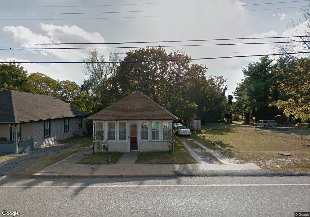
1152 Berkley Rd Gibbstown, NJ 08027
Greenwich Township NeighborhoodEstimated Value: $174,495 - $294,000
--
Bed
--
Bath
840
Sq Ft
$275/Sq Ft
Est. Value
About This Home
This home is located at 1152 Berkley Rd, Gibbstown, NJ 08027 and is currently estimated at $230,624, approximately $274 per square foot. 1152 Berkley Rd is a home located in Gloucester County with nearby schools including Nehaunsey Middle School and Guardian Angels Regional School.
Ownership History
Date
Name
Owned For
Owner Type
Purchase Details
Closed on
Jan 10, 2020
Sold by
Shorter Bruce B and Shorter Joan D
Bought by
Shorter Joan D and Terrell Aaron
Current Estimated Value
Home Financials for this Owner
Home Financials are based on the most recent Mortgage that was taken out on this home.
Interest Rate
3.64%
Create a Home Valuation Report for This Property
The Home Valuation Report is an in-depth analysis detailing your home's value as well as a comparison with similar homes in the area
Home Values in the Area
Average Home Value in this Area
Purchase History
| Date | Buyer | Sale Price | Title Company |
|---|---|---|---|
| Shorter Joan D | -- | -- |
Source: Public Records
Mortgage History
| Date | Status | Borrower | Loan Amount |
|---|---|---|---|
| Closed | Shorter Joan D | -- |
Source: Public Records
Tax History Compared to Growth
Tax History
| Year | Tax Paid | Tax Assessment Tax Assessment Total Assessment is a certain percentage of the fair market value that is determined by local assessors to be the total taxable value of land and additions on the property. | Land | Improvement |
|---|---|---|---|---|
| 2025 | $3,705 | $107,600 | $23,000 | $84,600 |
| 2024 | $3,510 | $107,600 | $23,000 | $84,600 |
| 2023 | $3,510 | $107,600 | $23,000 | $84,600 |
| 2022 | $3,512 | $107,600 | $23,000 | $84,600 |
| 2021 | $3,475 | $107,600 | $23,000 | $84,600 |
| 2020 | $3,524 | $107,600 | $23,000 | $84,600 |
| 2019 | $3,526 | $107,600 | $23,000 | $84,600 |
| 2018 | $3,426 | $107,600 | $23,000 | $84,600 |
| 2017 | $3,343 | $107,600 | $23,000 | $84,600 |
| 2016 | $3,307 | $107,600 | $23,000 | $84,600 |
| 2015 | $3,200 | $107,600 | $23,000 | $84,600 |
| 2014 | $3,062 | $107,600 | $23,000 | $84,600 |
Source: Public Records
Map
Nearby Homes
- 255 Elizabeth Ave
- 1224 Heddon Ave
- 1214 Walter Ave
- 219 Vanneman Blvd
- 330 Croce Ave
- L18 20 W Broad St
- 1534 Pine St
- 269 W Broad St
- 1519 Pine St
- 335 W Buck St
- 836 E Broad St
- 344 W Washington St
- 131 Jessup St
- 227 W Buck St
- 0 Lodge Ave
- 8 S Delaware St
- L5 Lodge Ave
- L8 Lodge Ave
- 122 W Washington St
- 1043 Penn Line Rd
- 1156 Berkley Rd
- 1160 Berkley Rd
- 1164 Berkley Rd
- 1144 Berkley Rd
- 1168 Berkley Rd
- 1126 Berkley Rd
- 129 Swedesboro Ave
- 113 Berkley Rd
- 1180 Berkley Rd
- 1118 Berkley Rd
- 1184 Berkley Rd
- 123 Swedesboro Ave
- 135 Swedesboro Ave
- 1216 Berkley Rd
- 1116 Berkley Rd
- 420 Summit Ave
- 416 Summit Ave
- 424 Summit Ave
- 412 Summit Ave
- 428 Summit Ave