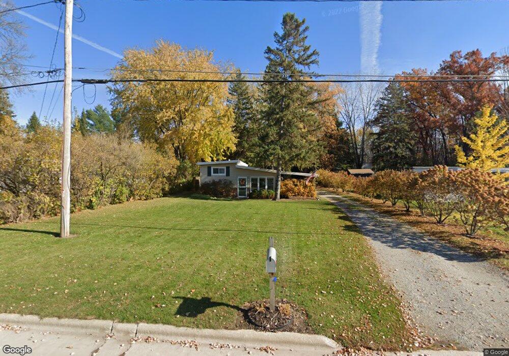
1153 Hobart Dr Green Bay, WI 54304
Westside NeighborhoodEstimated Value: $216,157 - $322,000
--
Bed
--
Bath
--
Sq Ft
0.54
Acres
About This Home
This home is located at 1153 Hobart Dr, Green Bay, WI 54304 and is currently estimated at $271,289. 1153 Hobart Dr is a home located in Brown County with nearby schools including MacArthur Elementary School, Lombardi Middle School, and Southwest High School.
Ownership History
Date
Name
Owned For
Owner Type
Purchase Details
Closed on
Nov 16, 2001
Sold by
Lecoque Todd S
Bought by
Mcfall Diane M
Current Estimated Value
Home Financials for this Owner
Home Financials are based on the most recent Mortgage that was taken out on this home.
Original Mortgage
$71,200
Outstanding Balance
$27,623
Interest Rate
6.62%
Estimated Equity
$243,666
Create a Home Valuation Report for This Property
The Home Valuation Report is an in-depth analysis detailing your home's value as well as a comparison with similar homes in the area
Home Values in the Area
Average Home Value in this Area
Purchase History
| Date | Buyer | Sale Price | Title Company |
|---|---|---|---|
| Mcfall Diane M | $75,000 | Liberty Title |
Source: Public Records
Mortgage History
| Date | Status | Borrower | Loan Amount |
|---|---|---|---|
| Open | Mcfall Diane M | $71,200 |
Source: Public Records
Tax History Compared to Growth
Tax History
| Year | Tax Paid | Tax Assessment Tax Assessment Total Assessment is a certain percentage of the fair market value that is determined by local assessors to be the total taxable value of land and additions on the property. | Land | Improvement |
|---|---|---|---|---|
| 2024 | $2,442 | $137,300 | $62,800 | $74,500 |
| 2023 | $2,304 | $137,300 | $62,800 | $74,500 |
| 2022 | $2,274 | $137,300 | $62,800 | $74,500 |
| 2021 | $1,813 | $85,500 | $33,800 | $51,700 |
| 2020 | $1,866 | $85,500 | $33,800 | $51,700 |
| 2019 | $1,791 | $85,500 | $33,800 | $51,700 |
| 2018 | $1,759 | $85,500 | $33,800 | $51,700 |
| 2017 | $1,759 | $85,500 | $33,800 | $51,700 |
| 2016 | $1,727 | $85,500 | $33,800 | $51,700 |
| 2015 | $1,840 | $85,500 | $33,800 | $51,700 |
| 2014 | $1,937 | $85,500 | $33,800 | $51,700 |
| 2013 | $1,937 | $85,500 | $33,800 | $51,700 |
Source: Public Records
Map
Nearby Homes
- 2439 W Point Rd
- 2441 Matchwood Ln
- 2550 He Nis Ra Ln
- 510 Lambeau St
- 1306 Nelson St Unit 1308
- 1779 9th St
- 2640 He Nis Ra Ln
- 1433 Baumgart Rd Unit 1435
- 1921 Beech Tree Dr
- 1973 Knotty Pine Dr
- 2466 Parkwood Dr
- 2610 Sumac Place
- 2060 Trissino Way
- 2044 Ann Ln
- 1428 Argonne Dr
- 1471 Parkway Dr
- 1514 Ashley Ct
- 1522 Argonne Dr
- 2060 Wintergreen Ct
- 806 Sunny Ln Unit 808
- 1145 Hobart Dr
- 1205 Hobart Dr
- 1152 Hobart Dr
- 1156 Hobart Dr
- 1159 Hobart Dr Unit BLOCK
- 1159 Hobart Dr
- 1142 Hobart Dr
- 1138 Hobart Dr
- 1209 Hobart Dr
- 1133 Hobart Dr
- 1132 Hobart Dr
- 2424 Bellwood Ln Unit 2426
- 2418 Bellwood Ln Unit 2420
- 2466 Trojan Dr
- 2471 Trojan Dr
- 1233 Hobart Dr
- 2421 Bellwood Ln Unit 2423
- 1151 Delray Dr
- 2472 Trojan Dr
- 1217 Delray Dr Unit 1219