Estimated Value: $166,000 - $182,000
3
Beds
2
Baths
1,456
Sq Ft
$120/Sq Ft
Est. Value
About This Home
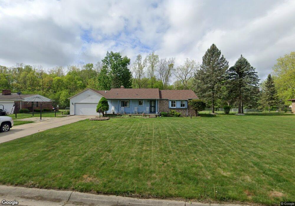
This home is located at 1154 Greenstone Ln, Flint, MI 48532 and is currently estimated at $174,084, approximately $119 per square foot. 1154 Greenstone Ln is a home located in Genesee County with nearby schools including Carman-Ainsworth High School, Genesee STEM Academy, and St. Paul Lutheran School.
Ownership History
Date
Name
Owned For
Owner Type
Purchase Details
Closed on
Jun 20, 2003
Sold by
Kellum William
Bought by
Kellum William and Kellum Patricia
Current Estimated Value
Home Financials for this Owner
Home Financials are based on the most recent Mortgage that was taken out on this home.
Original Mortgage
$145,000
Interest Rate
5.37%
Mortgage Type
New Conventional
Purchase Details
Closed on
Jan 25, 1999
Sold by
Kellum Patricia A
Bought by
Kellum William and Kellum Patricia A
Create a Home Valuation Report for This Property
The Home Valuation Report is an in-depth analysis detailing your home's value as well as a comparison with similar homes in the area
Home Values in the Area
Average Home Value in this Area
Purchase History
| Date | Buyer | Sale Price | Title Company |
|---|---|---|---|
| Kellum William | -- | Title Direct | |
| Kellum William | -- | Fidelity National Title Ins |
Source: Public Records
Mortgage History
| Date | Status | Borrower | Loan Amount |
|---|---|---|---|
| Closed | Kellum William | $145,000 |
Source: Public Records
Tax History
| Year | Tax Paid | Tax Assessment Tax Assessment Total Assessment is a certain percentage of the fair market value that is determined by local assessors to be the total taxable value of land and additions on the property. | Land | Improvement |
|---|---|---|---|---|
| 2025 | $2,021 | $52,800 | $0 | $0 |
| 2024 | $1,032 | $53,400 | $0 | $0 |
| 2023 | $984 | $50,800 | $0 | $0 |
| 2022 | $1,005 | $46,700 | $0 | $0 |
| 2021 | $1,784 | $44,900 | $0 | $0 |
| 2020 | $884 | $43,400 | $0 | $0 |
| 2019 | $872 | $42,100 | $0 | $0 |
| 2018 | $1,663 | $39,800 | $0 | $0 |
| 2017 | $1,711 | $39,800 | $0 | $0 |
| 2016 | $1,647 | $38,600 | $0 | $0 |
| 2015 | $1,464 | $37,800 | $0 | $0 |
| 2014 | $869 | $36,400 | $0 | $0 |
| 2012 | -- | $39,400 | $39,400 | $0 |
Source: Public Records
Map
Nearby Homes
- 000 Devenish Ln
- 1034 Normandy Terrace Dr
- 1095 Devenish Ln
- 2 Charter Dr
- 4199 Sheraton Dr
- 0 Charter Dr Unit 50153638
- 1137 S Graham Rd
- 1090 Cabot Dr
- 3.9 Acres W Court St
- 1512 Crescent Lane Dr Lot#46
- Graham Rd N Graham Rd
- 4480 Corunna Rd
- 4474 Corunna Rd
- 4022 Beecher Rd
- 4075 Townview Dr
- 3528 Beecher Rd
- 1161 S Dye Rd
- 10 Acres T A Mansour Blvd
- 3493 Ridgecliffe Dr
- 3522 Ridgecliffe Dr
- 1166 Greenstone Ln
- 1138 Greenstone Ln
- 1171 Devenish Ln
- 1162 Devenish Ln
- 1104 Normandy Terrace Dr Unit 115
- 1104 Normandy Terrace Dr Unit 15
- 1104 Normandy Terrace Dr Unit 4
- 1103 Normandy Terrace Dr Unit 114
- 1102 Normandy Terrace Dr
- 1102 Normandy Terrace Dr Unit 113
- 1102 Normandy Terrace Dr Unit 4
- 1091 Normandy Terrace Dr Unit 116
- 1091 Normandy Terrace Dr Unit 5
- 1101 Normandy Terrace Dr
- 1092 Normandy Terrace Dr Unit 117
- 1092 Normandy Terrace Dr Unit 5
- 1093 Normandy Terrace Dr
- 1114 Normandy Terrace Dr
- 1094 Normandy Terrace Dr
- 1161 Devenish Ln
Your Personal Tour Guide
Ask me questions while you tour the home.