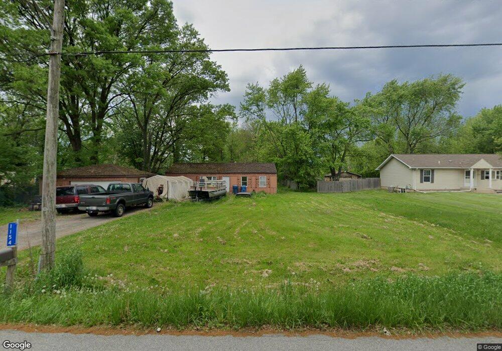
1154 N Salt Creek Rd Burns Harbor, IN 46304
Estimated Value: $209,000 - $285,000
3
Beds
1
Bath
1,344
Sq Ft
$184/Sq Ft
Est. Value
About This Home
This home is located at 1154 N Salt Creek Rd, Burns Harbor, IN 46304 and is currently estimated at $246,682, approximately $183 per square foot. 1154 N Salt Creek Rd is a home located in Porter County with nearby schools including Newton Yost Elementary School, Westchester Intermediate School, and Chesterton Middle School.
Ownership History
Date
Name
Owned For
Owner Type
Purchase Details
Closed on
Sep 7, 2010
Sold by
U S Bank National Association
Bought by
Depew Robert M
Current Estimated Value
Purchase Details
Closed on
Jul 28, 2010
Sold by
Luke Cynthia A and Luke Thomas A
Bought by
U S Bank National Association
Create a Home Valuation Report for This Property
The Home Valuation Report is an in-depth analysis detailing your home's value as well as a comparison with similar homes in the area
Home Values in the Area
Average Home Value in this Area
Purchase History
| Date | Buyer | Sale Price | Title Company |
|---|---|---|---|
| Depew Robert M | -- | Security Title Services Llc | |
| U S Bank National Association | $101,000 | None Available |
Source: Public Records
Tax History Compared to Growth
Tax History
| Year | Tax Paid | Tax Assessment Tax Assessment Total Assessment is a certain percentage of the fair market value that is determined by local assessors to be the total taxable value of land and additions on the property. | Land | Improvement |
|---|---|---|---|---|
| 2024 | $791 | $121,800 | $27,800 | $94,000 |
| 2023 | $726 | $114,800 | $25,700 | $89,100 |
| 2022 | $706 | $107,300 | $25,700 | $81,600 |
| 2021 | $595 | $99,700 | $25,700 | $74,000 |
| 2020 | $568 | $96,600 | $22,600 | $74,000 |
| 2019 | $504 | $88,800 | $22,600 | $66,200 |
| 2018 | $463 | $86,100 | $22,600 | $63,500 |
| 2017 | $433 | $85,100 | $22,600 | $62,500 |
| 2016 | $426 | $84,900 | $23,700 | $61,200 |
| 2014 | $394 | $80,400 | $22,600 | $57,800 |
| 2013 | -- | $73,000 | $21,800 | $51,200 |
Source: Public Records
Map
Nearby Homes
- 376 Melton Rd
- 1164 Tanya St
- 357 Melton Rd
- 1609 Melanie Ln
- 1138 Weaver Way
- 1136 Weaver Way
- 1848 Truman St
- 0 Burns Blvd
- 1151 Burns Blvd
- The Duneland Plan at Village in Burns Harbor
- 168 Harbor Way
- 169 Harbor Way
- 326 Clifford Way
- 1162 Chesterfield Ave
- 1766 Samuelson Rd
- 1935 Samuelson Rd
- V/L U S 20
- 2176 Mccool Rd
- 2168 Austin St
- 6698 Monument Ave
- 1154 Salt Creek Rd
- 1158 Salt Creek Rd
- 1152 Salt Creek Rd
- 387 Melton Rd
- 1160 N Salt Creek Rd
- 1160 Salt Creek Rd
- 1160 Salt Dr
- 1155 Salt Creek Rd
- 376 Marilyn Rd
- D S Boo Rd
- 389 Melton Rd
- 1162 Salt Creek Rd
- 375 Marilyn Rd
- 1159 Salt Creek Rd
- 377 Melton Rd
- 391 Melton Rd
- C S Boo Rd
- 374 Marilyn Rd
- 1161 Salt Creek Rd
- 1166 Salt Creek Rd