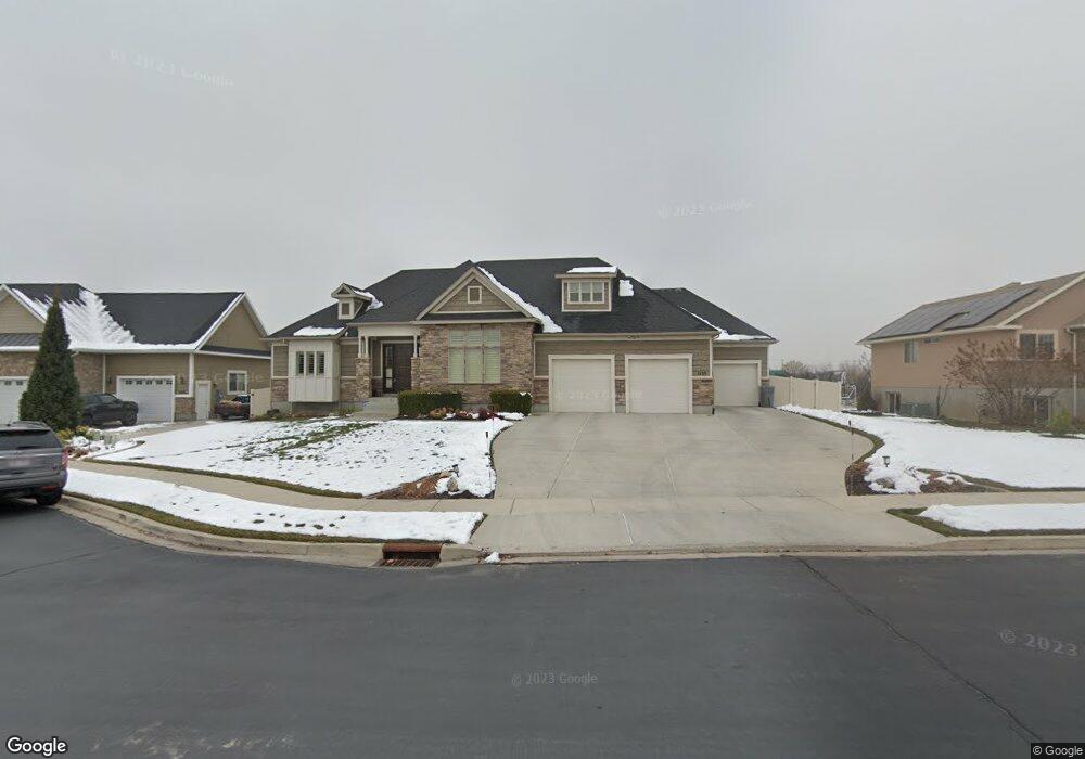
1155 N 1050 E American Fork, UT 84003
Estimated Value: $807,000 - $1,050,000
3
Beds
2
Baths
4,620
Sq Ft
$190/Sq Ft
Est. Value
About This Home
This home is located at 1155 N 1050 E, American Fork, UT 84003 and is currently estimated at $879,244, approximately $190 per square foot. 1155 N 1050 E is a home located in Utah County with nearby schools including Deerfield Elementary School, Mountain Ridge Junior High School, and American Fork High School.
Ownership History
Date
Name
Owned For
Owner Type
Purchase Details
Closed on
Jul 13, 2012
Sold by
Rojas Daniel Mario and Rojas Alison
Bought by
Rojas Daniel and Rojas Alison
Current Estimated Value
Home Financials for this Owner
Home Financials are based on the most recent Mortgage that was taken out on this home.
Original Mortgage
$375,650
Outstanding Balance
$159,829
Interest Rate
3.63%
Mortgage Type
New Conventional
Estimated Equity
$719,415
Purchase Details
Closed on
Dec 22, 2008
Sold by
Haven Homes Inc
Bought by
Rojas Daniel Mario and Rojas Alison
Home Financials for this Owner
Home Financials are based on the most recent Mortgage that was taken out on this home.
Original Mortgage
$387,375
Interest Rate
6.03%
Mortgage Type
VA
Create a Home Valuation Report for This Property
The Home Valuation Report is an in-depth analysis detailing your home's value as well as a comparison with similar homes in the area
Home Values in the Area
Average Home Value in this Area
Purchase History
| Date | Buyer | Sale Price | Title Company |
|---|---|---|---|
| Rojas Daniel | -- | Morgan Title & Escrow Inc | |
| Rojas Daniel Mario | -- | Signature Title Insurance A |
Source: Public Records
Mortgage History
| Date | Status | Borrower | Loan Amount |
|---|---|---|---|
| Open | Rojas Daniel | $375,650 | |
| Closed | Rojas Daniel Mario | $387,375 |
Source: Public Records
Tax History
| Year | Tax Paid | Tax Assessment Tax Assessment Total Assessment is a certain percentage of the fair market value that is determined by local assessors to be the total taxable value of land and additions on the property. | Land | Improvement |
|---|---|---|---|---|
| 2025 | $3,546 | $417,230 | -- | -- |
| 2024 | $3,546 | $394,020 | $0 | $0 |
| 2023 | $3,357 | $395,505 | $0 | $0 |
| 2022 | $3,430 | $398,695 | $0 | $0 |
| 2021 | $3,008 | $546,200 | $175,000 | $371,200 |
| 2020 | $2,927 | $515,500 | $162,000 | $353,500 |
| 2019 | $2,768 | $504,200 | $150,700 | $353,500 |
| 2018 | $2,769 | $482,300 | $143,100 | $339,200 |
| 2017 | $2,593 | $243,760 | $0 | $0 |
| 2016 | $2,674 | $233,530 | $0 | $0 |
| 2015 | $2,542 | $210,650 | $0 | $0 |
| 2014 | $2,551 | $208,560 | $0 | $0 |
Source: Public Records
Map
Nearby Homes
- 1162 E 1180 N
- 1089 N 950 E
- 1058 N 930 E Unit 64
- 1045 N 930 E Unit 58
- 1125 N 1270 E
- 1243 N 1270 E
- 1172 Murdock Dr
- 9587 N 4500 W
- 9617 N 4500 W
- 4675 W Ferguson Way
- 4552 W Windsor Cir
- 9752 N Dorchester Dr
- 1121 E 580 N
- 4979 W Willowbank Dr
- 649 N 1280 E
- 2421 Renaissance Ct
- 4947 Evergreen Ln
- 4968 W Evergreen Ln
- 5061 W Evergreen Ln
- 5042 W Green Ash Ln