Estimated Value: $110,000 - $148,000
2
Beds
1
Bath
988
Sq Ft
$136/Sq Ft
Est. Value
About This Home
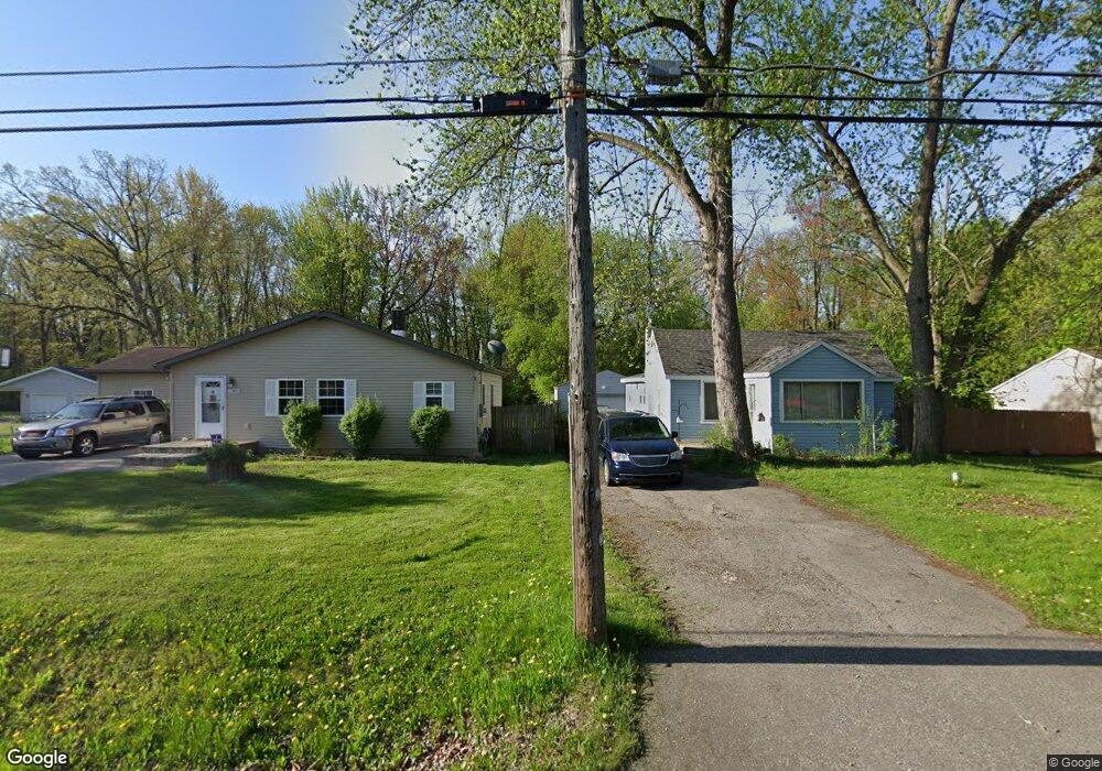
This home is located at 1156 Lincoln Dr, Flint, MI 48507 and is currently estimated at $134,554, approximately $136 per square foot. 1156 Lincoln Dr is a home located in Genesee County with nearby schools including Anderson Elementary School, McGrath Elementary School, and Grand Blanc West Middle School.
Ownership History
Date
Name
Owned For
Owner Type
Purchase Details
Closed on
Nov 13, 2018
Sold by
Frank Jeremy M
Bought by
Smith Noah A and Smith Erin M
Current Estimated Value
Purchase Details
Closed on
Nov 22, 2000
Sold by
Pringle Paul A and Wizauer Anthony J
Bought by
Frank Jeremy M
Home Financials for this Owner
Home Financials are based on the most recent Mortgage that was taken out on this home.
Original Mortgage
$64,800
Interest Rate
7.86%
Create a Home Valuation Report for This Property
The Home Valuation Report is an in-depth analysis detailing your home's value as well as a comparison with similar homes in the area
Home Values in the Area
Average Home Value in this Area
Purchase History
| Date | Buyer | Sale Price | Title Company |
|---|---|---|---|
| Smith Noah A | $43,000 | None Available | |
| Frank Jeremy M | $72,000 | Lawyers Title Insurance Corp |
Source: Public Records
Mortgage History
| Date | Status | Borrower | Loan Amount |
|---|---|---|---|
| Previous Owner | Frank Jeremy M | $64,800 |
Source: Public Records
Tax History Compared to Growth
Tax History
| Year | Tax Paid | Tax Assessment Tax Assessment Total Assessment is a certain percentage of the fair market value that is determined by local assessors to be the total taxable value of land and additions on the property. | Land | Improvement |
|---|---|---|---|---|
| 2025 | $1,609 | $47,900 | $0 | $0 |
| 2024 | $895 | $45,900 | $0 | $0 |
| 2023 | $854 | $37,600 | $0 | $0 |
| 2022 | $1,421 | $35,700 | $0 | $0 |
| 2021 | $1,399 | $38,400 | $0 | $0 |
| 2020 | $787 | $32,100 | $0 | $0 |
| 2019 | $776 | $30,300 | $0 | $0 |
| 2018 | $1,382 | $29,000 | $0 | $0 |
| 2017 | $1,337 | $27,300 | $0 | $0 |
| 2016 | $1,322 | $21,300 | $0 | $0 |
| 2015 | $1,279 | $21,300 | $0 | $0 |
| 2012 | -- | $29,000 | $29,000 | $0 |
Source: Public Records
Map
Nearby Homes
- 0 Harding Dr Unit 20251056693
- 00 Mckinley Blvd
- 000 Mckinley Blvd
- 1096 Harding Dr
- 1226 Harding Dr
- 0000 Mckinley Blvd
- 0000 Coolidge Dr
- 00 Coolidge Dr
- 000 Coolidge Dr
- 1045 Leisure Dr Unit 7
- 1075 E Hill Rd
- 1329 Rollins St
- 1037 E Hill Rd
- 1130 Leisure Dr Unit 21
- 5400 Ali Dr
- 5152 Sandalwood Cir
- 5148 Sandalwood Cir
- 5146 Sandalwood Cir
- 6137 Pebbleshire Dr
- 1044 W Rowland St
- 1144 Lincoln Dr
- 1160 Lincoln Dr
- 1176 Lincoln Dr
- 1136 Lincoln Dr
- 1153 Lincoln Dr
- 1165 Lincoln Dr
- 1173 Lincoln Dr
- 1143 Lincoln Dr
- 1122 Lincoln Dr
- 1196 Lincoln Dr
- 1123 Lincoln Dr
- 1191 Lincoln Dr
- 1121 Washington Dr
- 1121 Washington Dr
- 1157 Mckinley Blvd
- 1141 Mckinley Blvd
- 1153 Harding Dr
- 1201 Lincoln Dr
- 1105 Lincoln Dr
- 1212 Lincoln Dr