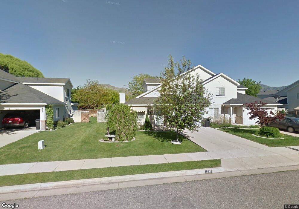
1156 N 320 W Logan, UT 84341
Bridger NeighborhoodEstimated Value: $335,000 - $390,445
3
Beds
2
Baths
1,498
Sq Ft
$235/Sq Ft
Est. Value
About This Home
This home is located at 1156 N 320 W, Logan, UT 84341 and is currently estimated at $352,361, approximately $235 per square foot. 1156 N 320 W is a home located in Cache County with nearby schools including Bridger School, Mount Logan Middle School, and Logan High School.
Ownership History
Date
Name
Owned For
Owner Type
Purchase Details
Closed on
Jan 3, 2025
Sold by
Jacobson Larry K and Jacobson Marilyn B
Bought by
Jacobson Larry K and Jacobson Marilyn B
Current Estimated Value
Purchase Details
Closed on
Jun 14, 2017
Sold by
Sorenson Joycelyn T
Bought by
Jacobson Larry K and Jacobson Marilyn B
Home Financials for this Owner
Home Financials are based on the most recent Mortgage that was taken out on this home.
Original Mortgage
$164,423
Interest Rate
4.02%
Mortgage Type
New Conventional
Purchase Details
Closed on
Jul 19, 2006
Sold by
Dillenbeck Vernon Robert and Dillenbeck Beth
Bought by
Sorenson Joycelyn T
Purchase Details
Closed on
Apr 25, 2005
Sold by
Williams Mark T
Bought by
Dillenbeck Vernon Robert and Dillenbeck Beth
Purchase Details
Closed on
Jun 12, 2002
Sold by
Oliver Kristin M
Bought by
Williams Mark T
Create a Home Valuation Report for This Property
The Home Valuation Report is an in-depth analysis detailing your home's value as well as a comparison with similar homes in the area
Home Values in the Area
Average Home Value in this Area
Purchase History
| Date | Buyer | Sale Price | Title Company |
|---|---|---|---|
| Jacobson Larry K | -- | Cache Title | |
| Jason R Rich And Kari J Rich Revocable Trust | -- | None Listed On Document | |
| Jacobson Larry K | -- | Cache Title | |
| Jacobson Larry K | -- | Hickman Land Title Co | |
| Sorenson Joycelyn T | -- | American Secure Title | |
| Dillenbeck Vernon Robert | -- | American Secure Title | |
| Williams Mark T | -- | Northern Title Company |
Source: Public Records
Mortgage History
| Date | Status | Borrower | Loan Amount |
|---|---|---|---|
| Previous Owner | Jacobson Larry K | $164,423 |
Source: Public Records
Tax History Compared to Growth
Tax History
| Year | Tax Paid | Tax Assessment Tax Assessment Total Assessment is a certain percentage of the fair market value that is determined by local assessors to be the total taxable value of land and additions on the property. | Land | Improvement |
|---|---|---|---|---|
| 2025 | $1,604 | $377,118 | $132,600 | $244,518 |
| 2024 | $1,656 | $377,118 | $132,600 | $244,518 |
| 2023 | $1,725 | $374,518 | $130,000 | $244,518 |
| 2022 | $1,591 | $322,518 | $78,000 | $244,518 |
| 2021 | $1,368 | $235,615 | $40,000 | $195,615 |
| 2020 | $1,324 | $205,209 | $40,000 | $165,209 |
| 2019 | $1,384 | $205,209 | $40,000 | $165,209 |
| 2018 | $1,356 | $183,660 | $40,000 | $143,660 |
| 2017 | $1,234 | $88,330 | $0 | $0 |
| 2016 | $1,279 | $80,685 | $0 | $0 |
| 2015 | $1,095 | $75,520 | $0 | $0 |
| 2014 | $990 | $75,520 | $0 | $0 |
| 2013 | -- | $75,520 | $0 | $0 |
Source: Public Records
Map
Nearby Homes
- 2200 N 220 W
- 1030 N 130 W Unit 100
- 897 N 250 W
- 894 N 400 W
- 873 N 480 W
- 559 W 1350 N Unit 41
- 430 W 810 N
- 420 W 750 N
- 1515 N 450 W Unit 103
- 514 W 1490 N Unit 102
- 539 W 1465 N Unit 17-102
- 20 Kings Ct
- 223 W 730 N
- 243 W 730 N
- 190 W 700 N
- 345 W 690 N
- 365 W 690 N
- 1492 N 565 W Unit 101
- 190 Kings Ct
- 227 W 690 N