Estimated Value: $103,000 - $148,791
3
Beds
1
Bath
912
Sq Ft
$142/Sq Ft
Est. Value
About This Home
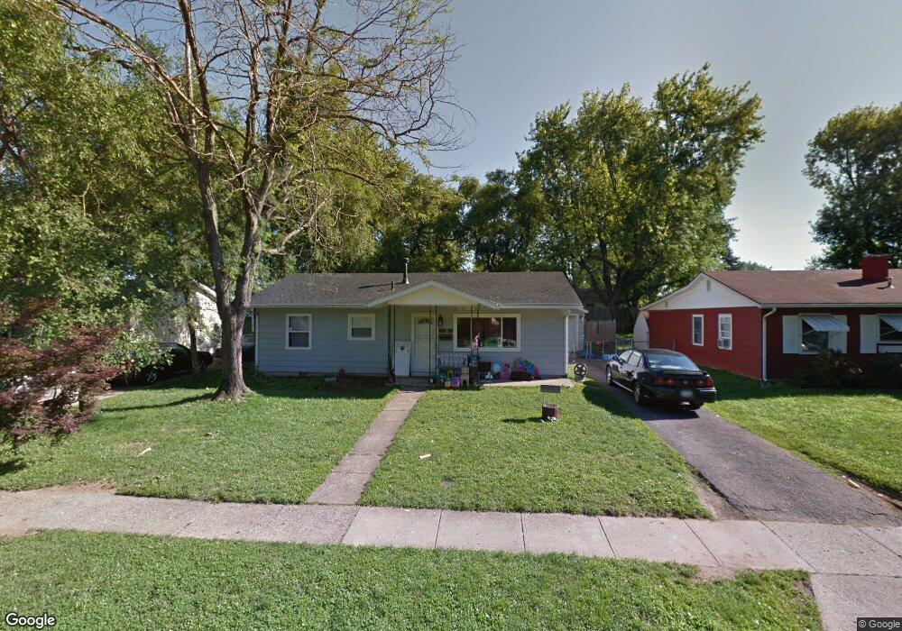
This home is located at 1156 Reid Ave, Xenia, OH 45385 and is currently estimated at $129,948, approximately $142 per square foot. 1156 Reid Ave is a home located in Greene County with nearby schools including Xenia High School, Summit Academy Community School for Alternative Learners - Xenia, and Legacy Christian Academy.
Ownership History
Date
Name
Owned For
Owner Type
Purchase Details
Closed on
Mar 27, 2018
Sold by
Moles Dorothy J
Bought by
Evans Cody A and Boyle Saraha N
Current Estimated Value
Home Financials for this Owner
Home Financials are based on the most recent Mortgage that was taken out on this home.
Original Mortgage
$65,900
Outstanding Balance
$56,620
Interest Rate
4.4%
Mortgage Type
New Conventional
Estimated Equity
$73,328
Purchase Details
Closed on
Apr 9, 2004
Sold by
Fifth Third Mortgage Co
Bought by
Moles Dorothy J
Home Financials for this Owner
Home Financials are based on the most recent Mortgage that was taken out on this home.
Original Mortgage
$56,700
Interest Rate
5.66%
Mortgage Type
Unknown
Purchase Details
Closed on
Dec 17, 2003
Sold by
Sweet Michael D and Sweet Kathy
Bought by
Fifth Third Mortgage Co
Create a Home Valuation Report for This Property
The Home Valuation Report is an in-depth analysis detailing your home's value as well as a comparison with similar homes in the area
Home Values in the Area
Average Home Value in this Area
Purchase History
| Date | Buyer | Sale Price | Title Company |
|---|---|---|---|
| Evans Cody A | $68,000 | First Ohio Title | |
| Moles Dorothy J | $63,000 | -- | |
| Fifth Third Mortgage Co | $59,000 | -- |
Source: Public Records
Mortgage History
| Date | Status | Borrower | Loan Amount |
|---|---|---|---|
| Open | Evans Cody A | $65,900 | |
| Previous Owner | Moles Dorothy J | $56,700 |
Source: Public Records
Tax History Compared to Growth
Tax History
| Year | Tax Paid | Tax Assessment Tax Assessment Total Assessment is a certain percentage of the fair market value that is determined by local assessors to be the total taxable value of land and additions on the property. | Land | Improvement |
|---|---|---|---|---|
| 2024 | $1,415 | $33,070 | $7,940 | $25,130 |
| 2023 | $1,415 | $33,070 | $7,940 | $25,130 |
| 2022 | $1,170 | $23,320 | $5,670 | $17,650 |
| 2021 | $1,186 | $23,320 | $5,670 | $17,650 |
| 2020 | $1,136 | $23,320 | $5,670 | $17,650 |
| 2019 | $1,069 | $20,660 | $4,250 | $16,410 |
| 2018 | $1,073 | $20,660 | $4,250 | $16,410 |
| 2017 | $1,042 | $20,660 | $4,250 | $16,410 |
| 2016 | $1,028 | $19,420 | $4,250 | $15,170 |
| 2015 | $1,031 | $19,420 | $4,250 | $15,170 |
| 2014 | $987 | $19,420 | $4,250 | $15,170 |
Source: Public Records
Map
Nearby Homes
- 1223 June Dr
- 1233 June Dr
- 1283 June Dr
- 343 Sheelin Rd
- 1391 June Dr
- 1342 Kylemore Dr
- 1351 Omard Dr
- 883 Omard Dr
- 912 Omard Dr
- 509 Antrim Rd
- 1144 Rockwell Dr
- 305-325 Bellbrook Ave
- 121 S Progress Dr
- 453 Walnut St
- 1568 Cheyenne Dr
- 613 N West St
- 0 W Church St
- 1208 Bellbrook Ave
- 137 Pleasant St
- 1272 Bellbrook Ave
- 1144 Reid Ave
- 1168 Reid Ave
- 1141 Frost Circle Dr
- 1132 Reid Ave
- 1151 Frost Circle Dr
- 1180 Reid Ave
- 1131 Frost Circle Dr
- 1167 Reid Ave
- 1141 Reid Ave
- 1163 Frost Circle Dr
- 1192 Reid Ave
- 1120 Reid Ave
- 1119 Frost Circle Dr
- 1179 Reid Ave
- 1129 Reid Ave
- 1191 Reid Ave
- 1105 Frost Circle Dr
- 1110 Reid Ave
- 77 Sheelin Rd
- 1173 Frost Circle Dr