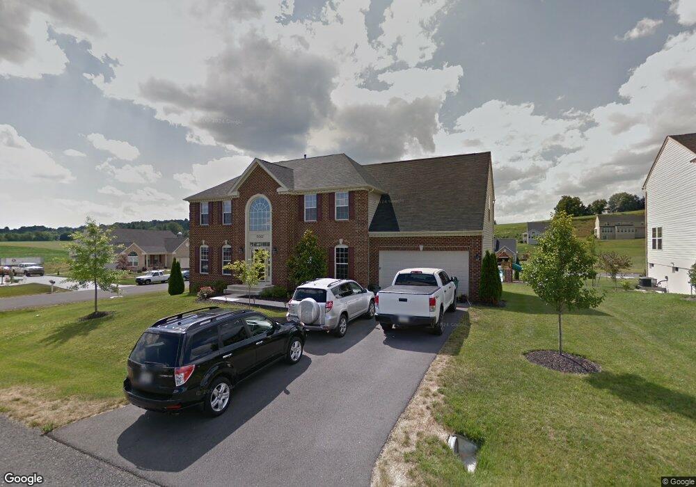
11567 Lady Dell Dr Ln Waynesboro, PA 17268
Estimated Value: $441,000 - $575,151
--
Bed
1
Bath
3,158
Sq Ft
$157/Sq Ft
Est. Value
About This Home
This home is located at 11567 Lady Dell Dr Ln, Waynesboro, PA 17268 and is currently estimated at $497,288, approximately $157 per square foot. 11567 Lady Dell Dr Ln is a home located in Franklin County with nearby schools including Waynesboro Area Senior High School, Noah's Ark Christian Child Care Center, and St. Andrew Catholic School.
Ownership History
Date
Name
Owned For
Owner Type
Purchase Details
Closed on
May 29, 2008
Sold by
Nvr Inc
Bought by
Brewer Terry G and Brewer Jessica T
Current Estimated Value
Home Financials for this Owner
Home Financials are based on the most recent Mortgage that was taken out on this home.
Original Mortgage
$315,793
Outstanding Balance
$203,470
Interest Rate
6.13%
Mortgage Type
VA
Estimated Equity
$293,818
Create a Home Valuation Report for This Property
The Home Valuation Report is an in-depth analysis detailing your home's value as well as a comparison with similar homes in the area
Home Values in the Area
Average Home Value in this Area
Purchase History
| Date | Buyer | Sale Price | Title Company |
|---|---|---|---|
| Brewer Terry G | $315,793 | None Available |
Source: Public Records
Mortgage History
| Date | Status | Borrower | Loan Amount |
|---|---|---|---|
| Open | Brewer Terry G | $315,793 |
Source: Public Records
Tax History Compared to Growth
Tax History
| Year | Tax Paid | Tax Assessment Tax Assessment Total Assessment is a certain percentage of the fair market value that is determined by local assessors to be the total taxable value of land and additions on the property. | Land | Improvement |
|---|---|---|---|---|
| 2025 | $6,128 | $39,890 | $4,800 | $35,090 |
| 2024 | $5,948 | $39,890 | $4,800 | $35,090 |
| 2023 | $5,772 | $39,890 | $4,800 | $35,090 |
| 2022 | $5,601 | $39,890 | $4,800 | $35,090 |
| 2021 | $5,398 | $39,570 | $4,800 | $34,770 |
| 2020 | $5,315 | $39,570 | $4,800 | $34,770 |
| 2019 | $5,196 | $39,570 | $4,800 | $34,770 |
| 2018 | $5,028 | $39,570 | $4,800 | $34,770 |
| 2017 | $4,919 | $39,570 | $4,800 | $34,770 |
| 2016 | $1,134 | $39,570 | $4,800 | $34,770 |
| 2015 | $1,057 | $39,570 | $4,800 | $34,770 |
| 2014 | $1,057 | $39,570 | $4,800 | $34,770 |
Source: Public Records
Map
Nearby Homes
- 11555 Mystic Rock Ln N
- 11802 Mystic Rock Ln S
- 11798 Mystic Rock Ln S
- 11797 Mystic Rock Ln S
- 10842 Sierra Dr
- 10851 Sierra Dr
- 11226 Gopher Dr N
- 8796 Hillside Way
- 0 Stottlemyer Rd Unit PAFL2024422
- 12398 Shelby Ave
- 11902 Rinehart Dr
- 11439 Viking Ave
- 11412 Viking Ave
- 11405 Cross Fields Dr
- 11144 Ridge Crest Dr Unit 89
- 9383 Oyer Dr
- 11044 Cross Fields Dr
- 11008 Cross Fields Dr
- 845 Mountain View Rd
- 108 Antietam Dr
- 11555 Lady Dell Dr Ln
- 11562 Buhrman Dr W
- 9925 Gentle Creek Ln
- 11540 Buhrman Dr W
- 11568 Lady Dell Dr
- 9937 Gentle Creek Ln
- 11568 Lady Dell Dr Ln
- 11543 Lady Dell Dr Ln
- 11554 Lady Dell Dr Ln
- 9949 Gentle Creek Ln
- 11534 Buhrman Dr W
- 11548 Lady Dell Dr
- 9913 Gentle Creek Ln
- 11548 Lady Dell Dr Ln
- 9961 Gentle Creek Ln
- 11537 Lady Dell Dr Ln
- 11516 Buhrman Dr W
- 9845 Gentle Creek Ln
- 11549 Buhrman Dr W
- 11382 Buhrman Dr E