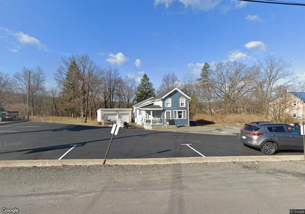
1158 Derrig St Dunmore, PA 18512
Estimated Value: $136,668 - $322,000
--
Bed
--
Bath
--
Sq Ft
0.96
Acres
About This Home
This home is located at 1158 Derrig St, Dunmore, PA 18512 and is currently estimated at $196,167. 1158 Derrig St is a home located in Lackawanna County with nearby schools including Red Mountain School, Dunmore Elementary Center, and St. Mary of Mount Carmel School.
Ownership History
Date
Name
Owned For
Owner Type
Purchase Details
Closed on
May 2, 2018
Sold by
Sabia Kevin and Sabia Kimberly
Bought by
Sabia William J and Sabia Lori A
Current Estimated Value
Home Financials for this Owner
Home Financials are based on the most recent Mortgage that was taken out on this home.
Original Mortgage
$102,400
Outstanding Balance
$88,251
Interest Rate
4.44%
Mortgage Type
New Conventional
Estimated Equity
$107,916
Purchase Details
Closed on
Mar 25, 1996
Bought by
Sabia Theresa and Sabia Kevin
Create a Home Valuation Report for This Property
The Home Valuation Report is an in-depth analysis detailing your home's value as well as a comparison with similar homes in the area
Home Values in the Area
Average Home Value in this Area
Purchase History
| Date | Buyer | Sale Price | Title Company |
|---|---|---|---|
| Sabia William J | $128,000 | -- | |
| Sabia Theresa | -- | -- |
Source: Public Records
Mortgage History
| Date | Status | Borrower | Loan Amount |
|---|---|---|---|
| Open | Sabia William J | $102,400 |
Source: Public Records
Tax History Compared to Growth
Tax History
| Year | Tax Paid | Tax Assessment Tax Assessment Total Assessment is a certain percentage of the fair market value that is determined by local assessors to be the total taxable value of land and additions on the property. | Land | Improvement |
|---|---|---|---|---|
| 2025 | $1,791 | $6,000 | $800 | $5,200 |
| 2024 | $1,531 | $6,000 | $800 | $5,200 |
| 2023 | $1,531 | $6,000 | $800 | $5,200 |
| 2022 | $1,436 | $6,000 | $800 | $5,200 |
| 2021 | $1,407 | $6,000 | $800 | $5,200 |
| 2020 | $1,407 | $6,000 | $800 | $5,200 |
| 2019 | $1,346 | $6,000 | $800 | $5,200 |
| 2018 | $1,324 | $6,000 | $800 | $5,200 |
| 2017 | $1,286 | $6,000 | $800 | $5,200 |
| 2016 | $566 | $6,000 | $800 | $5,200 |
| 2015 | -- | $6,000 | $800 | $5,200 |
| 2014 | -- | $6,000 | $800 | $5,200 |
Source: Public Records
Map
Nearby Homes
- 216 Prospect St
- 715 Moritz St
- 618 Shirley Ln
- 604 Marjorie Dr
- 305 Reeves St
- 322 Oak St
- 350 Smith St Unit L 70
- 427 E Warren St
- 410 Smith St
- 212 E Elm St
- 12 Baldassari Dr
- 141 Walnut St
- 503 Smith St
- 219 E Elm St
- 507 Smith St
- Lot A-1 Baldassari Dr
- 7 Tiffany Dr
- 314 E Drinker St
- 225, 233 E 301 East Drinker Stret
- 213 N Apple St
- 1150 Derrig St
- 0 E Drinker St Unit GSB232540
- 0 E Drinker St Unit GSB122094
- 0 E Drinker St
- 1144 E Drinker St
- 1157 E Drinker St
- 1159 E Drinker St
- 1140 Branch St
- 1142 E Drinker St
- 1172 E Drinker St
- 1134 Hennigan St
- 1136 Derrig St
- 1205 E Drinker St
- 119 River St
- 1132 Derrig St
- 110 Tigue St
- 1010 E Drinker St
- 1008 E Drinker St
- 1211 E Drinker St
- 1130 Branch St