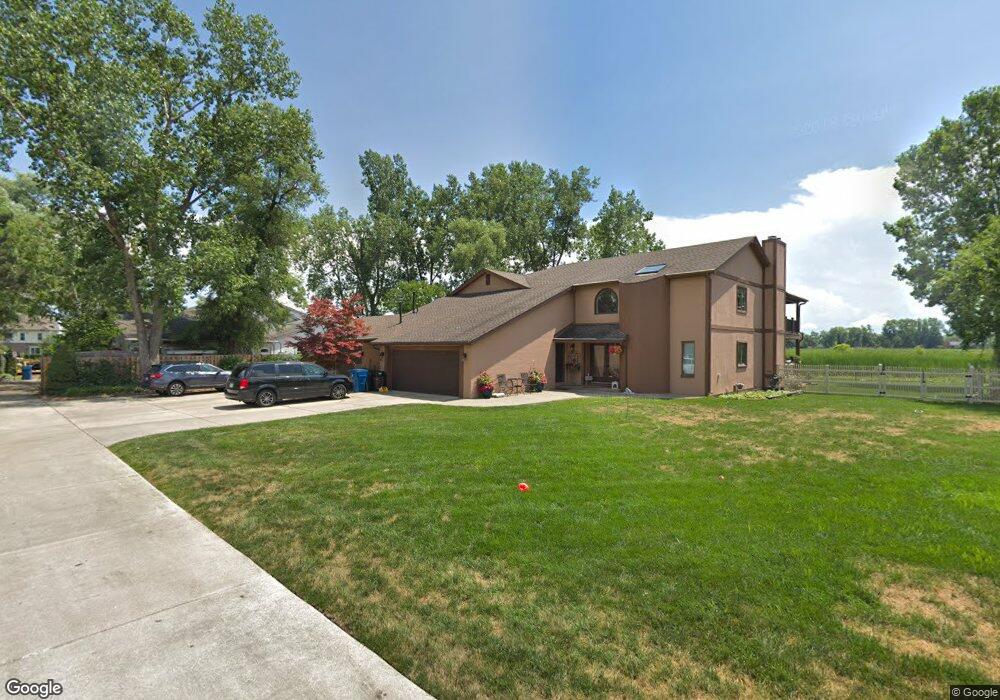
1159 Shady Ln Waterford, MI 48327
Waterford Township NeighborhoodEstimated Value: $656,000 - $936,000
3
Beds
4
Baths
5,294
Sq Ft
$152/Sq Ft
Est. Value
About This Home
This home is located at 1159 Shady Ln, Waterford, MI 48327 and is currently estimated at $804,798, approximately $152 per square foot. 1159 Shady Ln is a home located in Oakland County with nearby schools including Haviland Elementary School, Pierce Middle School, and Waterford Mott High School.
Ownership History
Date
Name
Owned For
Owner Type
Purchase Details
Closed on
Oct 3, 2023
Sold by
Seman Adel I & Latifa Asso
Bought by
Seman Family Joint Revocable Trust
Current Estimated Value
Purchase Details
Closed on
Jul 11, 2006
Sold by
Tyghem Mark L
Bought by
Hsbc Mortgage Corp Usa
Purchase Details
Closed on
May 8, 2000
Sold by
Tyghem Mark L
Bought by
Tyghem Mark L
Purchase Details
Closed on
Jul 16, 1999
Sold by
Weaver Stanley G
Bought by
Tyghem Mark L
Purchase Details
Closed on
May 27, 1997
Sold by
Peruski Lisa
Bought by
Weaver Stanley G
Create a Home Valuation Report for This Property
The Home Valuation Report is an in-depth analysis detailing your home's value as well as a comparison with similar homes in the area
Home Values in the Area
Average Home Value in this Area
Purchase History
| Date | Buyer | Sale Price | Title Company |
|---|---|---|---|
| Seman Family Joint Revocable Trust | -- | None Listed On Document | |
| Hsbc Mortgage Corp Usa | $470,265 | None Available | |
| Tyghem Mark L | -- | -- | |
| Tyghem Mark L | $575,000 | -- | |
| Weaver Stanley G | $523,000 | -- |
Source: Public Records
Tax History Compared to Growth
Tax History
| Year | Tax Paid | Tax Assessment Tax Assessment Total Assessment is a certain percentage of the fair market value that is determined by local assessors to be the total taxable value of land and additions on the property. | Land | Improvement |
|---|---|---|---|---|
| 2024 | $3,558 | $316,870 | $0 | $0 |
| 2023 | $6,414 | $523,220 | $0 | $0 |
| 2022 | $12,211 | $497,220 | $0 | $0 |
| 2021 | $11,530 | $485,320 | $0 | $0 |
| 2020 | $5,871 | $587,200 | $0 | $0 |
| 2019 | $11,083 | $567,240 | $0 | $0 |
| 2018 | $9,815 | $485,960 | $0 | $0 |
| 2017 | $9,336 | $485,960 | $0 | $0 |
| 2016 | $8,966 | $396,400 | $0 | $0 |
| 2015 | -- | $357,710 | $0 | $0 |
| 2014 | -- | $278,040 | $0 | $0 |
| 2011 | -- | $242,330 | $0 | $0 |
Source: Public Records
Map
Nearby Homes
- 1036 Pelham Blvd
- 1020 Charest Ave
- 4616 Cass Elizabeth Rd
- 4910 Chipman Dr
- 1522 Oregon Ct
- 4390 Cass Elizabeth Rd
- 1029 Monica Place
- 00000 Muskingum
- 1062 Forest Bay Dr
- 1079 Forest Bay Dr
- 1677 Parkview Ave
- 4275 Forest Valley Ct
- 5171 Durnham Dr
- 941 Shoshone Cir
- 4098 Parkway
- 4080 Cass Elizabeth Rd
- 1375 Nokomis Way
- 0000 VL (lot 016) Parkway St
- 549 Grixdale Ln
- 4405 Motorway Dr
- 1175 Shady Ln
- 1180 Shady Ln
- 1145 Shady Ln
- 1123 Shady Ln
- 4635 Charest Ave
- 1095 Shady Ln
- 1140 Shady Ln
- 4643 Charest Ave
- 1085 Shady Ln
- 1080 Shady Ln
- 4655 Charest Ave
- 4648 Charest Ave
- 4658 Chipman Dr
- 1075 Lalond Ave
- 1050 Pelham Blvd
- 4665 Charest Ave
- 1056 Pelham Blvd
- 0 Charest Unit 217098282
- 0 Charest Unit R219100568
- 4551 Hawkes Ave