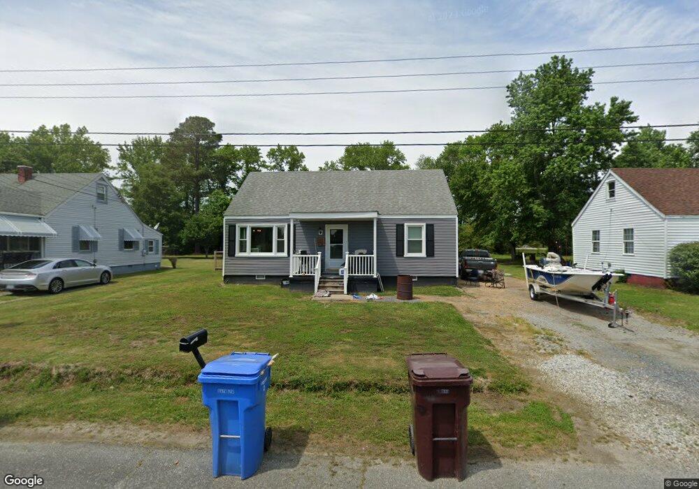
116 Carol Dr Chesapeake, VA 23322
Pleasant Grove West NeighborhoodEstimated Value: $286,000 - $355,000
2
Beds
1
Bath
864
Sq Ft
$367/Sq Ft
Est. Value
About This Home
This home is located at 116 Carol Dr, Chesapeake, VA 23322 and is currently estimated at $317,462, approximately $367 per square foot. 116 Carol Dr is a home located in Chesapeake City with nearby schools including Southeastern Elementary School, Hickory Middle School, and Hickory High School.
Ownership History
Date
Name
Owned For
Owner Type
Purchase Details
Closed on
Aug 9, 2019
Sold by
Diversified Equity Group Inc
Bought by
Bray Ryan D and Akers Ayanna R
Current Estimated Value
Home Financials for this Owner
Home Financials are based on the most recent Mortgage that was taken out on this home.
Original Mortgage
$174,503
Outstanding Balance
$152,927
Interest Rate
3.73%
Mortgage Type
New Conventional
Estimated Equity
$164,535
Purchase Details
Closed on
Apr 25, 2018
Sold by
Samuel I White Pc A Professional Corpora and Hinton Lora O
Bought by
Diversified Equity Group Inc
Home Financials for this Owner
Home Financials are based on the most recent Mortgage that was taken out on this home.
Original Mortgage
$100,000
Interest Rate
4.4%
Mortgage Type
Non Purchase Money Mortgage
Create a Home Valuation Report for This Property
The Home Valuation Report is an in-depth analysis detailing your home's value as well as a comparison with similar homes in the area
Home Values in the Area
Average Home Value in this Area
Purchase History
| Date | Buyer | Sale Price | Title Company |
|---|---|---|---|
| Bray Ryan D | $179,900 | Stewart Title Guaranty Co | |
| Diversified Equity Group Inc | $81,500 | None Available |
Source: Public Records
Mortgage History
| Date | Status | Borrower | Loan Amount |
|---|---|---|---|
| Open | Bray Ryan D | $174,503 | |
| Previous Owner | Diversified Equity Group Inc | $100,000 |
Source: Public Records
Tax History Compared to Growth
Tax History
| Year | Tax Paid | Tax Assessment Tax Assessment Total Assessment is a certain percentage of the fair market value that is determined by local assessors to be the total taxable value of land and additions on the property. | Land | Improvement |
|---|---|---|---|---|
| 2025 | $2,436 | $280,600 | $156,400 | $124,200 |
| 2024 | $2,436 | $241,200 | $122,400 | $118,800 |
| 2023 | $2,026 | $210,600 | $99,300 | $111,300 |
| 2022 | $2,037 | $201,700 | $96,400 | $105,300 |
| 2021 | $1,904 | $181,300 | $86,400 | $94,900 |
| 2020 | $1,814 | $172,800 | $86,400 | $86,400 |
| 2019 | $1,523 | $145,000 | $81,400 | $63,600 |
| 2018 | $1,504 | $143,200 | $81,400 | $61,800 |
| 2017 | $1,384 | $131,800 | $70,000 | $61,800 |
| 2016 | $1,384 | $131,800 | $70,000 | $61,800 |
| 2015 | $1,367 | $130,200 | $70,000 | $60,200 |
| 2014 | $1,367 | $130,200 | $70,000 | $60,200 |
Source: Public Records
Map
Nearby Homes
- 113 Gertrude St
- 109 Gertrude St
- 117 Gertrude St
- 105 Gertrude St
- 121 Gertrude St
- 101 Gertrude St
- 125 Gertrude St
- 1521 Bogue St
- 129 Gertrude St
- 1524 Bogue St
- 1520 Charlie St
- 133 Gertrude St
- 1517 Bogue St
- 1516 Charlie St
- 1520 Bogue St
- 132 Gertrude St
- 137 Gertrude St
- 1513 Bogue St
- 1512 Charlie St
- 136 Gertrude St
- 112 Carol Dr
- 120 Carol Dr
- 108 Carol Dr
- 124 Carol Dr
- 128 Carol Dr
- 1576 Battlefield Blvd S
- 1604 Battlefield Blvd S
- 1608 Battlefield Blvd S
- 1568 Battlefield Blvd S
- 1588 Battlefield Blvd S
- 1509 Bogue St
- 1624 Battlefield Blvd S
- 1640 Battlefield Blvd S
- 1544 Battlefield Blvd S
- 1500 Bogue St
- 1590 Battlefield Blvd S
- 120 Sandy Rd
- 1511 Battlefield Blvd S
- 1644 Battlefield Blvd S
- 1700 Battlefield Blvd S