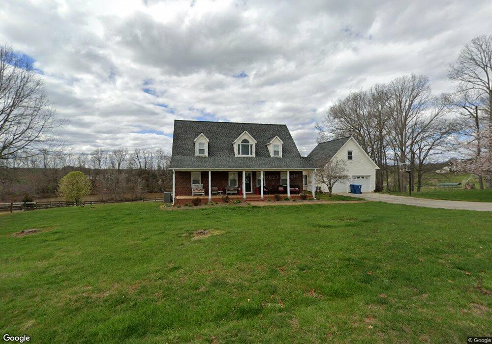
116 Clayton Dr Mocksville, NC 27028
Estimated Value: $362,000 - $549,000
3
Beds
3
Baths
2,468
Sq Ft
$188/Sq Ft
Est. Value
About This Home
This home is located at 116 Clayton Dr, Mocksville, NC 27028 and is currently estimated at $463,379, approximately $187 per square foot. 116 Clayton Dr is a home located in Davie County with nearby schools including Pinebrook Elementary School, North Davie Middle School, and Davie County High School.
Ownership History
Date
Name
Owned For
Owner Type
Purchase Details
Closed on
Feb 11, 2005
Sold by
Logan Stephen Gray
Bought by
Logan Ann Elizabeth Norman
Current Estimated Value
Home Financials for this Owner
Home Financials are based on the most recent Mortgage that was taken out on this home.
Original Mortgage
$275,000
Outstanding Balance
$138,489
Interest Rate
5.61%
Mortgage Type
New Conventional
Estimated Equity
$324,890
Purchase Details
Closed on
Nov 1, 1987
Create a Home Valuation Report for This Property
The Home Valuation Report is an in-depth analysis detailing your home's value as well as a comparison with similar homes in the area
Home Values in the Area
Average Home Value in this Area
Purchase History
| Date | Buyer | Sale Price | Title Company |
|---|---|---|---|
| Logan Ann Elizabeth Norman | -- | -- | |
| -- | $3,000 | -- |
Source: Public Records
Mortgage History
| Date | Status | Borrower | Loan Amount |
|---|---|---|---|
| Open | Logan Ann Elizabeth Norman | $275,000 |
Source: Public Records
Tax History Compared to Growth
Tax History
| Year | Tax Paid | Tax Assessment Tax Assessment Total Assessment is a certain percentage of the fair market value that is determined by local assessors to be the total taxable value of land and additions on the property. | Land | Improvement |
|---|---|---|---|---|
| 2025 | $2,969 | $431,180 | $111,110 | $320,070 |
| 2024 | $2,634 | $340,800 | $90,910 | $249,890 |
| 2023 | $2,634 | $340,800 | $90,910 | $249,890 |
| 2022 | $2,634 | $340,800 | $90,910 | $249,890 |
| 2021 | $2,634 | $340,800 | $90,910 | $249,890 |
| 2020 | $2,590 | $332,870 | $90,910 | $241,960 |
| 2019 | $2,590 | $332,870 | $90,910 | $241,960 |
| 2018 | $2,590 | $332,870 | $90,910 | $241,960 |
| 2017 | $2,556 | $332,870 | $0 | $0 |
| 2016 | $2,613 | $340,180 | $0 | $0 |
| 2015 | $2,613 | $340,180 | $0 | $0 |
| 2014 | $2,245 | $340,180 | $0 | $0 |
| 2013 | -- | $340,180 | $0 | $0 |
Source: Public Records
Map
Nearby Homes
- 123 Cornwallis Dr
- 193 Ashley Ln
- Lot 1 Ashley Ln
- 00 Angell Rd
- 153 Summerlyn Dr
- 164 Dusty Hill Rd
- 2643 Nc Highway 801 N
- 118 Arrendal Ct
- 228 Meadowlark Ln
- 550 Danner Rd
- 0 Angell Rd
- Knollwood Plan at Providence Place
- Southmont Plan at Providence Place
- Aster Plan at Providence Place
- Ledford Plan at Providence Place
- Abbott Plan at Providence Place
- Cotton Grove Plan at Providence Place
- 2007 Farmington Rd
- 5304 U S Highway 601 N
- 114 Danner Rd
- 116 Clayton Dr Unit 2
- 144 Clayton Dr
- 810 Pudding Ridge Rd
- 105 Clayton Dr
- 110 Cecil Ln
- 160 Clayton Dr
- 139 Buckeye Trail
- 178 Cecil Ln Unit 3
- 214 Clayton Dr
- 157 Buckeye Trail
- 170 Cecil Ln
- 752 Pudding Ridge Rd
- 145 Cecil Ln
- 248 Clayton Dr
- 195 Buckeye Trail
- 724 Pudding Ridge Rd
- 256 Clayton Dr
- 184 Buckeye Trail
- 184 Buckeye Trail
- 979 Pudding Ridge Rd