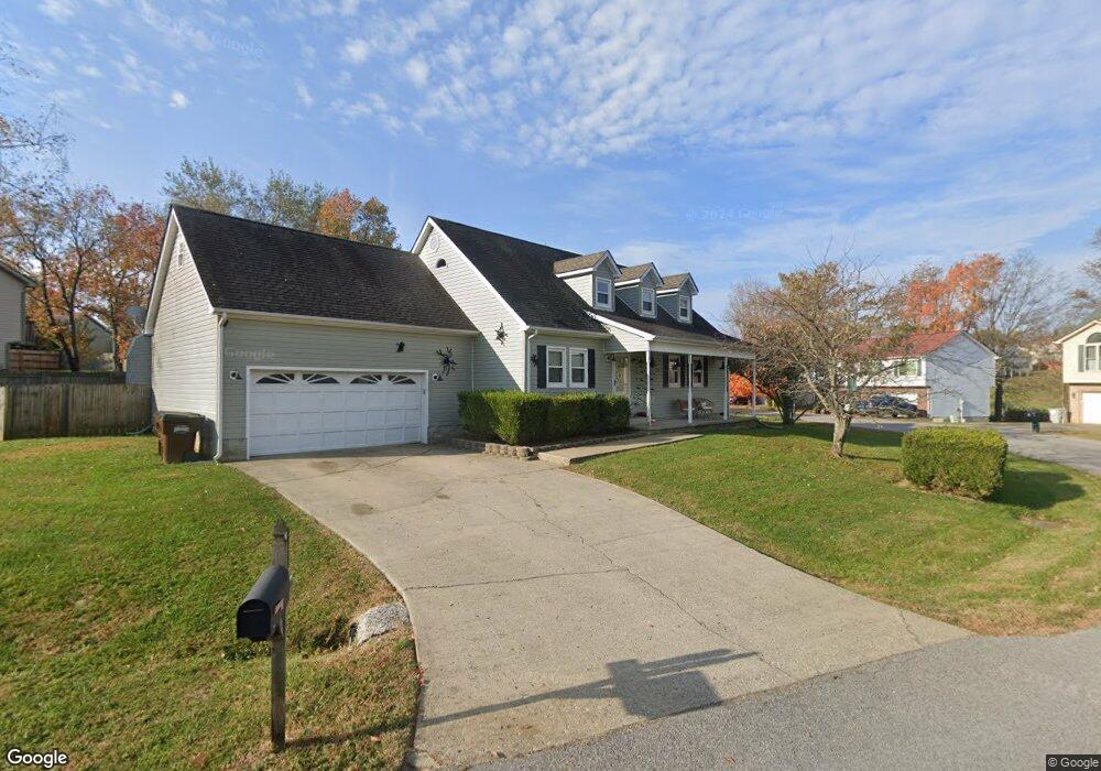
116 Devin Dr Georgetown, KY 40324
Estimated Value: $287,000 - $410,000
4
Beds
3
Baths
2,111
Sq Ft
$157/Sq Ft
Est. Value
About This Home
This home is located at 116 Devin Dr, Georgetown, KY 40324 and is currently estimated at $332,163, approximately $157 per square foot. 116 Devin Dr is a home located in Scott County with nearby schools including Stamping Ground Elementary School, Royal Spring Middle School, and Scott County High School.
Ownership History
Date
Name
Owned For
Owner Type
Purchase Details
Closed on
Aug 7, 2020
Sold by
Dukes Edward S and Dukes Lisa R
Bought by
Riley Noah J and Riley Alexis R
Current Estimated Value
Home Financials for this Owner
Home Financials are based on the most recent Mortgage that was taken out on this home.
Original Mortgage
$185,858
Outstanding Balance
$163,700
Interest Rate
3.1%
Mortgage Type
New Conventional
Estimated Equity
$168,463
Create a Home Valuation Report for This Property
The Home Valuation Report is an in-depth analysis detailing your home's value as well as a comparison with similar homes in the area
Purchase History
| Date | Buyer | Sale Price | Title Company |
|---|---|---|---|
| Riley Noah J | $184,000 | None Available |
Source: Public Records
Mortgage History
| Date | Status | Borrower | Loan Amount |
|---|---|---|---|
| Open | Riley Noah J | $185,858 |
Source: Public Records
Tax History
| Year | Tax Paid | Tax Assessment Tax Assessment Total Assessment is a certain percentage of the fair market value that is determined by local assessors to be the total taxable value of land and additions on the property. | Land | Improvement |
|---|---|---|---|---|
| 2025 | $2,637 | $296,100 | $0 | $0 |
| 2024 | $2,551 | $283,700 | $0 | $0 |
| 2023 | $2,376 | $262,100 | $25,000 | $237,100 |
| 2022 | $1,886 | $221,800 | $25,000 | $196,800 |
| 2021 | $1,821 | $207,600 | $25,000 | $182,600 |
| 2020 | $1,784 | $207,600 | $25,000 | $182,600 |
| 2019 | $1,739 | $199,300 | $0 | $0 |
| 2018 | $1,640 | $189,000 | $0 | $0 |
| 2017 | $1,610 | $184,580 | $0 | $0 |
| 2016 | $1,034 | $128,448 | $0 | $0 |
| 2015 | $1,020 | $127,500 | $0 | $0 |
| 2014 | $974 | $127,500 | $0 | $0 |
| 2011 | $1,000 | $137,500 | $0 | $0 |
Source: Public Records
Map
Nearby Homes
- 128 Thomas Ln
- 112 Lost Tree Dr
- 117 Windsong Way
- 169 Muir Ln
- 200 Victoria Way
- 162 Hidden Creek Dr
- 120 Creekside Dr
- 208 Craig Ln
- 103 Locust Grove Dr
- 106 Sand Piper Ct
- 140 Seahawk Trail
- 3200 Fishers Mill Rd
- 133 Treetop Ct
- 3612 Ironworks Rd
- 3669 Ironworks Rd Unit B-1
- 3669 Ironworks Rd Unit B-2
- 3669 Ironworks Rd Unit B-3
- 104 Lloyd Rd
- 635A Lot A White Oak Rd
- 122 Old Towne Walk
Your Personal Tour Guide
Ask me questions while you tour the home.