


116 E Maple St Cumming, GA 30040
Estimated payment $25,418/month
Highlights
- City View
- 2.95 Acre Lot
- Property is near shops
- Cumming Elementary School Rated A-
- No HOA
- No Heating
About This Lot
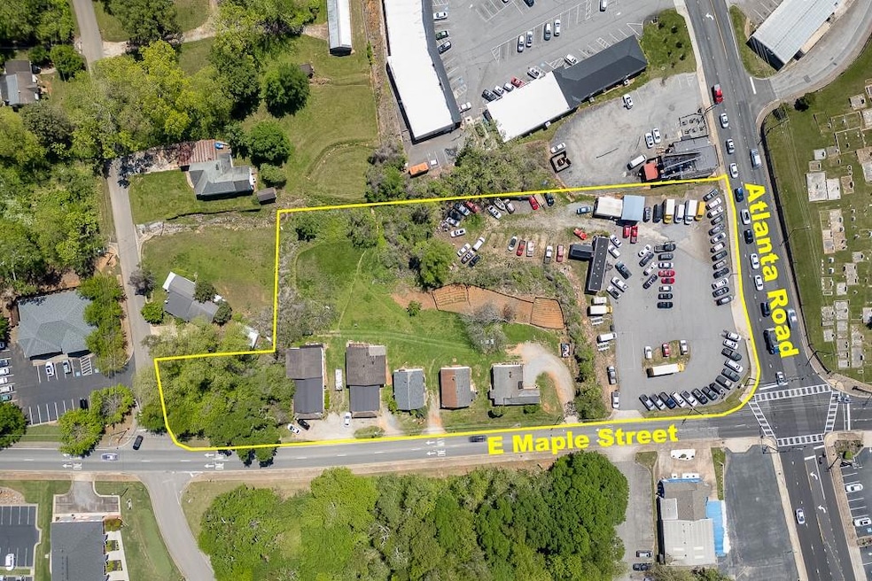
2.945 +/- Acres in Downtown Cumming and less than 1 mile from Hwy 400/ GA 19. This property is one of a kind being a double corner lot with frontage on 3 roads. High visibility corner with high traffic count and easy ingress and egress from multiple streets. The property is served by gravity flow sewer located on the front and rear of the property. There is access to City Water, Natural Gas, High Speed Internet, Phone and Cable. The property has approx 251' of frontage on Atlanta Hwy/ GA-9. Approx 617' of frontage on East Maple Street. Approx 90' of frontage on Allen Street. The 1.216+/- Acre corner parcel with frontage on Atlanta Road is zoned HB, which is accommodative to many commercial uses. The 1.143 +/- acre and .276+/- acre parcel is zoned CBD with is a general commercial zoning which is also accommodative to many commercial uses. This is a rare tract of land inside Downtown Cumming.
Listing Agent
Keller Williams Realty Community Partners Brokerage Phone: 678-341-7400 License #359833 Listed on: 07/22/2025

Property Details
Property Type
- Land
Est. Annual Taxes
- $3,957
Year Built
- Built in 1946
Lot Details
- 2.95 Acre Lot
- Property fronts a state road
- C16 099, C16 100
- Property is zoned HB, Commercial
Schools
- Cumming Elementary School
- Otwell Middle School
- Forsyth Central High School
Utilities
- Underground Utilities
- Cable TV Available
Additional Features
- City Views
- Property is near shops
Community Details
- No Home Owners Association
Listing and Financial Details
- Tax Lot 1269
- Assessor Parcel Number C16 098
Map
Home Values in the Area
Average Home Value in this Area
Tax History
| Year | Tax Paid | Tax Assessment Tax Assessment Total Assessment is a certain percentage of the fair market value that is determined by local assessors to be the total taxable value of land and additions on the property. | Land | Improvement |
|---|---|---|---|---|
| 2025 | $3,941 | $281,748 | $266,200 | $15,548 |
| 2024 | $3,941 | $160,700 | $145,200 | $15,500 |
| 2023 | $3,957 | $160,768 | $145,200 | $15,568 |
Property History
| Date | Event | Price | List to Sale | Price per Sq Ft |
|---|---|---|---|---|
| 07/22/2025 07/22/25 | For Sale | $4,875,000 | -- | -- |
Source: First Multiple Listing Service (FMLS)
MLS Number: 7619659
APN: C16-098
![]() Listings identified with the FMLS IDX logo come from FMLS and are held by brokerage firms other than the owner of this website. The listing brokerage is identified in any listing details. Information is deemed reliable but is not guaranteed. If you believe any FMLS listing contains material that infringes your copyrighted work please visit www.fmls.com/dmca to review our DMCA policy and learn how to submit a takedown request. © 2026 First Multiple Listing Service, Inc.
Listings identified with the FMLS IDX logo come from FMLS and are held by brokerage firms other than the owner of this website. The listing brokerage is identified in any listing details. Information is deemed reliable but is not guaranteed. If you believe any FMLS listing contains material that infringes your copyrighted work please visit www.fmls.com/dmca to review our DMCA policy and learn how to submit a takedown request. © 2026 First Multiple Listing Service, Inc.
Disclaimer: Certain information contained herein is derived from information provided by parties other than Homes.com. All information provided is deemed reliable, but is not guaranteed to be accurate and should be independently verified.
- 208 Pirkle Ferry Rd
- 123 Peaceful Grove Dr
- 104 Brackley Dr
- 112 Brackley Dr
- 115 Ridgecrest Ave
- 114 Brackley Dr
- 535 Shamrock Dr
- 460 Tribble Gap Rd Unit 102
- 460 Tribble Gap Rd Unit 501
- 0 Georgia 400 Unit 7490148
- 310 Samaritan Dr
- 491 Pearl St
- 1740, 1750, & 1 Buford Dam Rd
- 504 Pearl St
- 1244 Winterhaven Dr
- 522 Pearl St
- 526 Pearl St
- 528 Pearl St
- 547 Pearl St
- 551 Pearl St
- 123 Dog Path Trail
- 1220 Walden Crossing
- 98 Buford Dam Rd Unit 2204
- 98 Buford Dam Rd Unit 1301
- 98 Buford Dam Rd
- 98 Buford Dam Rd Unit SI ID1328930P
- 326 Canton Rd
- 530 Healy Dr
- 1244 Winterhaven Dr
- 525 Sawnee Village Blvd
- 2600 Castleberry Rd
- 409 Samaritan Dr
- 1500 Westshore Dr
- 1235 Weatherway Ln
- 1220 Waterfall Ct
- 530 Healy Dr
- 514 Alice Way Unit D15
- 3405 Castleberry Vil Cir
- 3403 Castleberry Village Cir
- 1740 Eaglecreek Trail
Ask me questions while you tour the home.