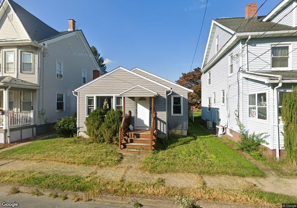
116 Independence St Selinsgrove, PA 17870
Estimated Value: $83,949 - $308,000
--
Bed
--
Bath
--
Sq Ft
5,663
Sq Ft Lot
About This Home
This home is located at 116 Independence St, Selinsgrove, PA 17870 and is currently estimated at $187,237. 116 Independence St is a home located in Snyder County with nearby schools including Selinsgrove Area Elementary School, Selinsgrove Intermediate School, and Selinsgrove Area Middle School.
Ownership History
Date
Name
Owned For
Owner Type
Purchase Details
Closed on
Oct 15, 2012
Sold by
Piermattei Fred M and Piermattei Nancy L
Bought by
Piermattei Anthony
Current Estimated Value
Home Financials for this Owner
Home Financials are based on the most recent Mortgage that was taken out on this home.
Original Mortgage
$72,750
Outstanding Balance
$50,496
Interest Rate
3.56%
Mortgage Type
New Conventional
Estimated Equity
$136,741
Create a Home Valuation Report for This Property
The Home Valuation Report is an in-depth analysis detailing your home's value as well as a comparison with similar homes in the area
Home Values in the Area
Average Home Value in this Area
Purchase History
| Date | Buyer | Sale Price | Title Company |
|---|---|---|---|
| Piermattei Anthony | $75,000 | -- |
Source: Public Records
Mortgage History
| Date | Status | Borrower | Loan Amount |
|---|---|---|---|
| Open | Piermattei Anthony | $72,750 |
Source: Public Records
Tax History Compared to Growth
Tax History
| Year | Tax Paid | Tax Assessment Tax Assessment Total Assessment is a certain percentage of the fair market value that is determined by local assessors to be the total taxable value of land and additions on the property. | Land | Improvement |
|---|---|---|---|---|
| 2025 | $1,632 | $13,640 | $1,700 | $11,940 |
| 2024 | $1,532 | $13,640 | $1,700 | $11,940 |
| 2023 | $611 | $13,640 | $1,700 | $11,940 |
| 2022 | $1,470 | $13,640 | $1,700 | $11,940 |
| 2021 | $1,457 | $13,640 | $1,700 | $11,940 |
| 2020 | $1,450 | $13,640 | $1,700 | $11,940 |
| 2019 | $1,443 | $13,640 | $1,700 | $11,940 |
| 2018 | $1,430 | $13,640 | $1,700 | $11,940 |
| 2017 | $1,416 | $13,640 | $1,700 | $11,940 |
| 2016 | $761 | $13,640 | $1,700 | $11,940 |
| 2015 | $50,212 | $13,640 | $1,700 | $11,940 |
| 2014 | $50,212 | $13,640 | $1,700 | $11,940 |
Source: Public Records
Map
Nearby Homes
- 207 Orange St Unit 209
- 211 W Pine St
- 500 N Orange St
- 511 N 10th St
- 722 N 8th St
- 00 S Market St
- 223 E Pine St
- Lot 1 522 Route S
- 321 Pleasant Dr
- 20 Quarry Rd
- 12 Minton Dr
- 456 State School Rd
- 0 Wedgewood Dr
- 9130 State Route 147
- 1262 N Old Trail
- 85 Old Colony Rd
- 732 Salem Rd
- 0 Mill Rd
- 594 Augusta Dr
- 0 Roosevelt Ave
- 114 Independence St
- 118 Independence St Unit 120
- 122 Independence St
- 112 Independence St
- 124 Independence St
- 128 Independence St
- 110 Independence St
- 229 W Snyder St
- 231 W Snyder St
- 227 W Snyder St
- 225 W Snyder St
- 233 W Snyder St
- 119 Independence St Unit 121
- 223 W Snyder St
- 123 Independence St
- 108 Independence St
- 117 Independence St
- 125 Independence St
- 219 W Snyder St
- 217 W Snyder St