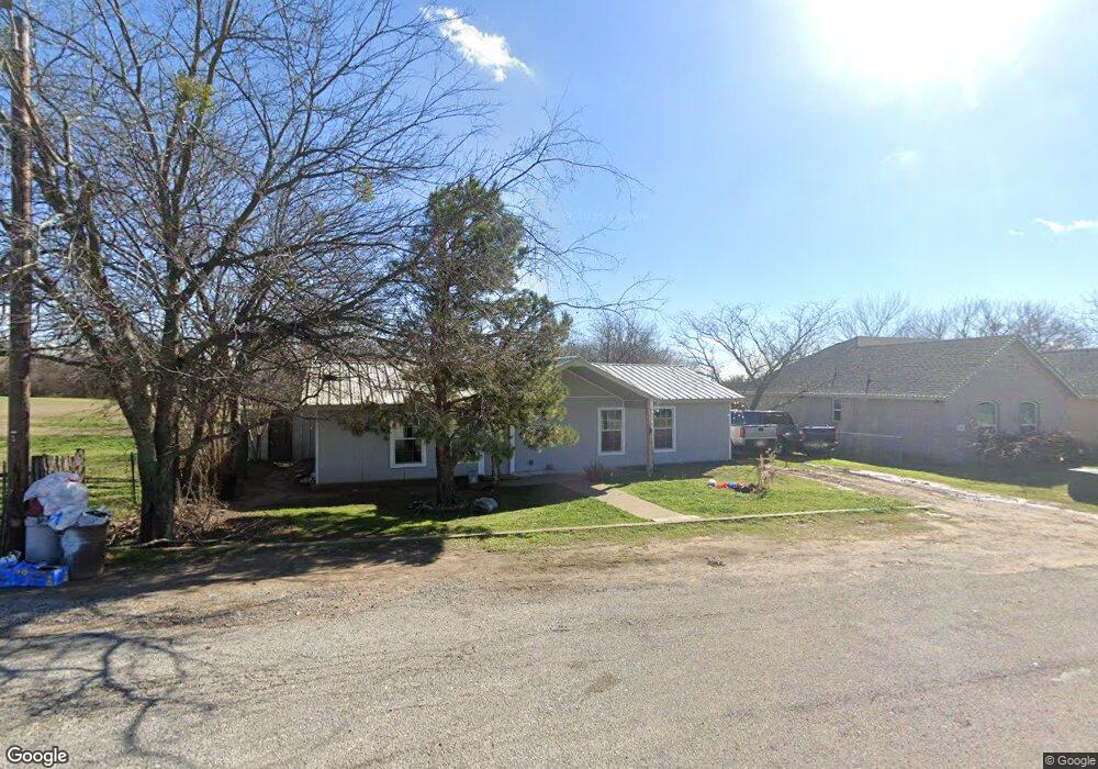
116 Karen St Weatherford, TX 76088
Estimated Value: $138,351 - $242,000
--
Bed
--
Bath
1,176
Sq Ft
$173/Sq Ft
Est. Value
About This Home
This home is located at 116 Karen St, Weatherford, TX 76088 and is currently estimated at $203,338, approximately $172 per square foot. 116 Karen St is a home with nearby schools including Peaster Elementary School, Peaster Middle School, and Peaster High School.
Ownership History
Date
Name
Owned For
Owner Type
Purchase Details
Closed on
Jul 23, 2018
Sold by
8 Investment Group Llc
Bought by
Schenk Timothy and Schenk Amber
Current Estimated Value
Home Financials for this Owner
Home Financials are based on the most recent Mortgage that was taken out on this home.
Original Mortgage
$148,480
Outstanding Balance
$128,965
Interest Rate
4.6%
Mortgage Type
VA
Estimated Equity
$74,373
Purchase Details
Closed on
Sep 17, 2013
Sold by
Hill Mark and Hill Jessica Ann
Bought by
Campos Fernando and Campos Marisol
Purchase Details
Closed on
Dec 5, 1983
Bought by
Campos Fernando and Campos Marisol
Create a Home Valuation Report for This Property
The Home Valuation Report is an in-depth analysis detailing your home's value as well as a comparison with similar homes in the area
Home Values in the Area
Average Home Value in this Area
Purchase History
| Date | Buyer | Sale Price | Title Company |
|---|---|---|---|
| Schenk Timothy | -- | Chicago Title | |
| Campos Fernando | -- | None Available | |
| Campos Fernando | -- | -- |
Source: Public Records
Mortgage History
| Date | Status | Borrower | Loan Amount |
|---|---|---|---|
| Open | Schenk Timothy | $148,480 |
Source: Public Records
Tax History Compared to Growth
Tax History
| Year | Tax Paid | Tax Assessment Tax Assessment Total Assessment is a certain percentage of the fair market value that is determined by local assessors to be the total taxable value of land and additions on the property. | Land | Improvement |
|---|---|---|---|---|
| 2025 | $1,327 | $63,380 | $25,000 | $38,380 |
| 2024 | $1,327 | $65,390 | $25,000 | $40,390 |
| 2023 | $1,327 | $65,390 | $25,000 | $40,390 |
| 2022 | $1,374 | $58,460 | $25,000 | $33,460 |
| 2021 | $1,399 | $58,460 | $25,000 | $33,460 |
| 2020 | $908 | $37,230 | $20,000 | $17,230 |
| 2019 | $947 | $37,230 | $20,000 | $17,230 |
| 2018 | $512 | $20,070 | $15,000 | $5,070 |
| 2017 | $514 | $20,070 | $15,000 | $5,070 |
| 2016 | $506 | $19,740 | $15,000 | $4,740 |
| 2015 | $495 | $19,740 | $15,000 | $4,740 |
| 2014 | $497 | $19,620 | $15,000 | $4,620 |
Source: Public Records
Map
Nearby Homes
- 107 Hall St
- 104 Lagrange Ct
- 905 Zion Hill Rd
- 105 Oxford Ct
- 2020 Vanderbilt Dr
- 2016 Vanderbilt Dr
- 2117 Pepperdine Dr
- Lot 11 Pepperdine Dr
- Lot 12 Pepperdine Dr
- Lot 10 Pepperdine Dr
- 1425 N Bowie Dr
- 2124 Pepperdine Dr
- 2000 Vanderbilt Dr
- 522 W 7th St
- 125 Odel Dr
- 1616 Oliver St
- 1813 Roadrunner Dr
- 1613 Franklin St
- 1727 N Main St
- TBD Hwy 920 Hwy