
Seller's Agent in 2025
Amy Rio
Executive Real Estate
(860) 916-6048
43 in this area
1,133 Total Sales
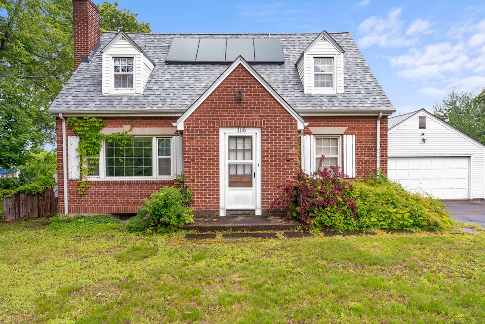
Charming Brick Cape with Bright Interiors & Bonus Space! Welcome to this beautifully maintained 3-bedroom, 2-bath brick Cape nestled in a desirable Wethersfield neighborhood. With 1,269 square feet of comfortable living space, this home blends classic charm with thoughtful updates throughout. Step into the sun-drenched living room, where a large picture window floods the space with natural light and highlights the gleaming hardwood floors. The functional layout includes a spacious kitchen and three well-sized bedrooms, with two full bathrooms for added convenience. Downstairs, the finished lower level offers fantastic versatility-perfect for a family room, home office, gym, or guest retreat. Outside, enjoy a level yard and a detached 2-car garage that offers plenty of storage. With solid brick construction, a great location, and a warm, inviting feel, this Cape is ready to welcome you home.
| Date | Type | Sale Price | Title Company |
|---|---|---|---|
| Warranty Deed | $320,000 | -- | |
| Warranty Deed | $217,000 | -- | |
| Warranty Deed | $217,000 | -- | |
| Deed | $168,000 | -- |
| Date | Status | Loan Amount | Loan Type |
|---|---|---|---|
| Open | $214,000 | Future Advance Clause Open End Mortgage | |
| Previous Owner | $13,951 | FHA | |
| Previous Owner | $206,261 | No Value Available | |
| Previous Owner | $217,000 | VA |
| Date | Event | Price | List to Sale | Price per Sq Ft |
|---|---|---|---|---|
| 07/22/2025 07/22/25 | Sold | $320,000 | +6.7% | $193 / Sq Ft |
| 06/12/2025 06/12/25 | Pending | -- | -- | -- |
| 06/10/2025 06/10/25 | For Sale | $299,900 | 0.0% | $181 / Sq Ft |
| 06/04/2025 06/04/25 | Pending | -- | -- | -- |
| 05/24/2025 05/24/25 | For Sale | $299,900 | -- | $181 / Sq Ft |
| Year | Tax Paid | Tax Assessment Tax Assessment Total Assessment is a certain percentage of the fair market value that is determined by local assessors to be the total taxable value of land and additions on the property. | Land | Improvement |
|---|---|---|---|---|
| 2025 | $8,927 | $216,570 | $76,470 | $140,100 |
| 2024 | $6,255 | $144,720 | $65,750 | $78,970 |
| 2023 | $6,046 | $144,720 | $65,750 | $78,970 |
| 2022 | $5,945 | $144,720 | $65,750 | $78,970 |
| 2021 | $5,886 | $144,720 | $65,750 | $78,970 |
| 2020 | $5,889 | $144,720 | $65,750 | $78,970 |
| 2019 | $5,896 | $144,720 | $65,750 | $78,970 |
| 2018 | $5,571 | $136,600 | $61,300 | $75,300 |
| 2017 | $5,433 | $136,600 | $61,300 | $75,300 |
| 2016 | $5,265 | $136,600 | $61,300 | $75,300 |
| 2015 | $5,217 | $136,600 | $61,300 | $75,300 |
| 2014 | $5,019 | $136,600 | $61,300 | $75,300 |
Seller's Agent in 2025
Amy Rio
Executive Real Estate
(860) 916-6048
43 in this area
1,133 Total Sales
Source: SmartMLS
MLS Number: 24098562
APN: WETH-000228-000000-000027
Disclaimer: Certain information contained herein is derived from information provided by parties other than Homes.com. All information provided is deemed reliable, but is not guaranteed to be accurate and should be independently verified.
![]() IDX information is provided exclusively for personal, non-commercial use, and may not be used for any purpose other than to identify prospective properties consumers may be interested in purchasing. Information is deemed reliable but not guaranteed.
IDX information is provided exclusively for personal, non-commercial use, and may not be used for any purpose other than to identify prospective properties consumers may be interested in purchasing. Information is deemed reliable but not guaranteed.
Ask me questions while you tour the home.