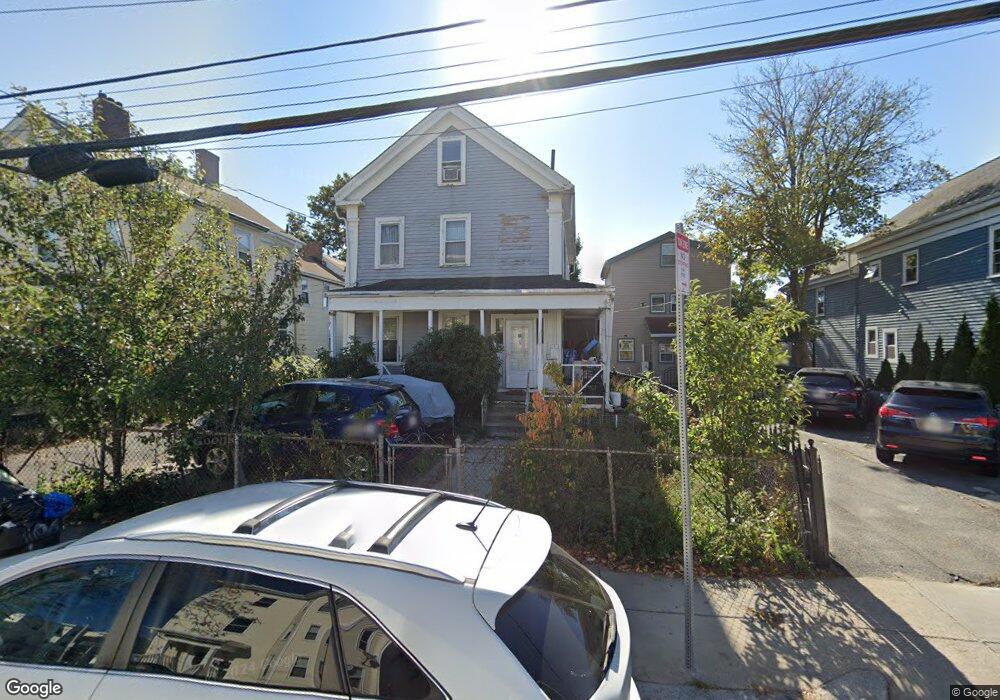
116 Park St Dorchester, MA 02122
Fields Corner East NeighborhoodEstimated Value: $870,641 - $938,000
5
Beds
3
Baths
2,497
Sq Ft
$364/Sq Ft
Est. Value
About This Home
This home is located at 116 Park St, Dorchester, MA 02122 and is currently estimated at $908,910, approximately $364 per square foot. 116 Park St is a home located in Suffolk County with nearby schools including UP Academy Charter School of Dorchester, Neighborhood House Charter School, and Helen Y. Davis Leadership Academy Charter Public School.
Ownership History
Date
Name
Owned For
Owner Type
Purchase Details
Closed on
Aug 3, 1993
Sold by
Progressive Cnsmrs Cu
Bought by
My Dao T
Current Estimated Value
Purchase Details
Closed on
Feb 13, 1992
Sold by
Moise Renold A
Bought by
Progressive Consum Fcu
Create a Home Valuation Report for This Property
The Home Valuation Report is an in-depth analysis detailing your home's value as well as a comparison with similar homes in the area
Home Values in the Area
Average Home Value in this Area
Purchase History
| Date | Buyer | Sale Price | Title Company |
|---|---|---|---|
| My Dao T | $43,000 | -- | |
| Progressive Consum Fcu | $52,000 | -- |
Source: Public Records
Mortgage History
| Date | Status | Borrower | Loan Amount |
|---|---|---|---|
| Previous Owner | Progressive Consum Fcu | $18,750 | |
| Previous Owner | Progressive Consum Fcu | $45,000 |
Source: Public Records
Tax History Compared to Growth
Tax History
| Year | Tax Paid | Tax Assessment Tax Assessment Total Assessment is a certain percentage of the fair market value that is determined by local assessors to be the total taxable value of land and additions on the property. | Land | Improvement |
|---|---|---|---|---|
| 2025 | $7,628 | $658,700 | $284,200 | $374,500 |
| 2024 | $7,134 | $654,500 | $274,500 | $380,000 |
| 2023 | $7,029 | $654,500 | $274,500 | $380,000 |
| 2022 | $6,778 | $623,000 | $261,300 | $361,700 |
| 2021 | $6,332 | $593,400 | $248,900 | $344,500 |
| 2020 | $5,413 | $512,600 | $232,700 | $279,900 |
| 2019 | $4,910 | $465,800 | $181,300 | $284,500 |
| 2018 | $4,521 | $431,400 | $181,300 | $250,100 |
| 2017 | $4,569 | $431,400 | $181,300 | $250,100 |
| 2016 | $4,395 | $399,500 | $181,300 | $218,200 |
| 2015 | $3,936 | $325,000 | $120,500 | $204,500 |
| 2014 | $3,526 | $280,300 | $120,500 | $159,800 |
Source: Public Records
Map
Nearby Homes
- 32 Gibson St Unit 3
- 20 Parkman St Unit 2
- 382 Adams St Unit 384-1
- 34 Dix St Unit 3
- 28 Dix St Unit 3
- 381 Adams St Unit 2
- 381 Adams St Unit 1
- 381 Adams St Unit 3
- 1613 Dorchester Ave Unit 1
- 20 Leslie St
- 15 Duncan St
- 17 Lafield St Unit 2
- 334 Centre St Unit 101
- 334 Centre St Unit 2
- 43 Robinson St Unit 3
- 32 Beach St Unit 1
- 15 Mather St
- 23 Tonawanda St
- 6 Agawam St
- 9 Park St Unit 8
- 118 Park St
- 114 Park St
- 120 Park St
- 120 Park St
- 120 Park St Unit A
- 120 Park St Unit R
- 120 Park St Unit 1
- 120 Park St Unit 2
- 117 Park St
- 117 Park St Unit 3
- 117 Park St Unit 2
- 117 Park St Unit 1
- 117 Park St
- 124 Park St
- 112 Park St
- 126 Park St
- 122R Park St
- 6 Bispham St
- 6 Bispham St Unit 6 Bispham 1
- 6 Bispham St