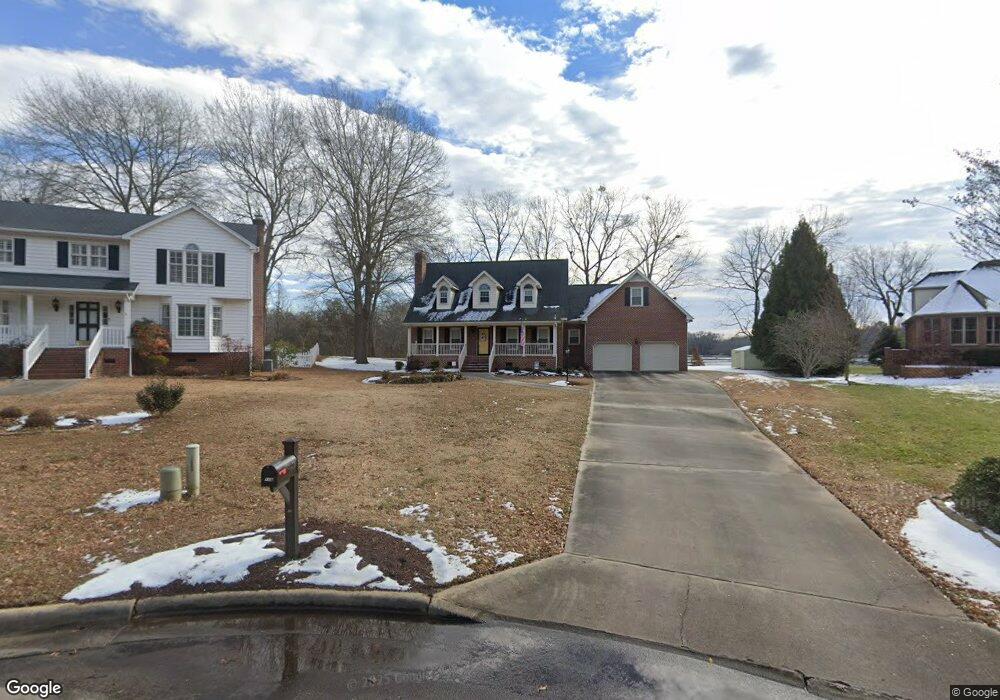
116 River Rd S Roanoke Rapids, NC 27870
Estimated Value: $283,000 - $365,000
3
Beds
3
Baths
2,679
Sq Ft
$124/Sq Ft
Est. Value
About This Home
This home is located at 116 River Rd S, Roanoke Rapids, NC 27870 and is currently estimated at $332,287, approximately $124 per square foot. 116 River Rd S is a home located in Northampton County with nearby schools including Gaston STEM Leadership Academy, Gaston Middle School, and Northampton County High School.
Ownership History
Date
Name
Owned For
Owner Type
Purchase Details
Closed on
Feb 19, 2025
Sold by
Bratton Carolyn
Bought by
Mcelheney Charles Preston and Mcelheney Lindsey Leake
Current Estimated Value
Purchase Details
Closed on
May 3, 1999
Bought by
Bratton William Timothy and Bratton Bratton,Carolyn C
Create a Home Valuation Report for This Property
The Home Valuation Report is an in-depth analysis detailing your home's value as well as a comparison with similar homes in the area
Home Values in the Area
Average Home Value in this Area
Purchase History
| Date | Buyer | Sale Price | Title Company |
|---|---|---|---|
| Mcelheney Charles Preston | $310,000 | None Listed On Document | |
| Mcelheney Charles Preston | $310,000 | None Listed On Document | |
| Bratton William Timothy | $22,500 | -- |
Source: Public Records
Tax History Compared to Growth
Tax History
| Year | Tax Paid | Tax Assessment Tax Assessment Total Assessment is a certain percentage of the fair market value that is determined by local assessors to be the total taxable value of land and additions on the property. | Land | Improvement |
|---|---|---|---|---|
| 2025 | $54 | $335,500 | $46,900 | $288,600 |
| 2024 | $54 | $335,500 | $46,900 | $288,600 |
| 2023 | $4,581 | $265,100 | $46,900 | $218,200 |
| 2022 | $4,650 | $265,100 | $46,900 | $218,200 |
| 2021 | $4,531 | $265,100 | $46,900 | $218,200 |
| 2020 | $4,573 | $265,100 | $46,900 | $218,200 |
| 2019 | $4,243 | $241,800 | $46,900 | $194,900 |
| 2018 | $4,154 | $241,800 | $46,900 | $194,900 |
| 2017 | $4,164 | $241,800 | $46,900 | $194,900 |
| 2016 | $4,268 | $241,800 | $46,900 | $194,900 |
| 2015 | $4,063 | $241,800 | $46,900 | $194,900 |
| 2014 | $4,551 | $284,310 | $53,020 | $231,290 |
Source: Public Records
Map
Nearby Homes
- 746 Rivers Edge Pkwy
- 748 Rivers Edge Pkwy
- 738 Rivers Edge Pkwy
- Taft Plan at Canal Walk
- Roosevelt Plan at Canal Walk
- Monroe Plan at Canal Walk
- Jefferson Plan at Canal Walk
- 755 Rivers Edge Pkwy
- 764 Rivers Edge Pkwy
- 766 Rivers Edge Pkwy
- 768 Rivers Edge Pkwy
- 769 Rivers Edge Pkwy
- 779 Rivers Edge Pkwy
- 770 Rivers Edge Pkwy
- 783 Rivers Edge Pkwy
- 772 Rivers Edge Pkwy
- 204 Rollingwood Rd
- 784 Rivers Edge Pkwy
- 786 Rivers Edge Pkwy
- 785 Rivers Edge Pkwy
- 116 River Rd S
- 114 River Rd S
- 118 River Rd S
- 112 River Rd S
- 110 River Rd S
- 110 River Rd S
- 108 River Rd S
- 108 River Rd S
- 106 River Rd S
- 744 Rivers Edge Pkwy
- 104 River Rd S
- 104 River Rd S
- 746 Rivers Edge Pkry
- 742 Rivers Edge Pkwy
- 105 River Rd S
- 740 Rivers Edge Pkwy
- 102 River Rd N
- 750 Rivers Edge Pkwy
- 103 River Rd S
- 752 Rivers Edge Pkwy