Estimated Value: $113,000 - $143,000
Studio
--
Bath
1,168
Sq Ft
$110/Sq Ft
Est. Value
About This Home
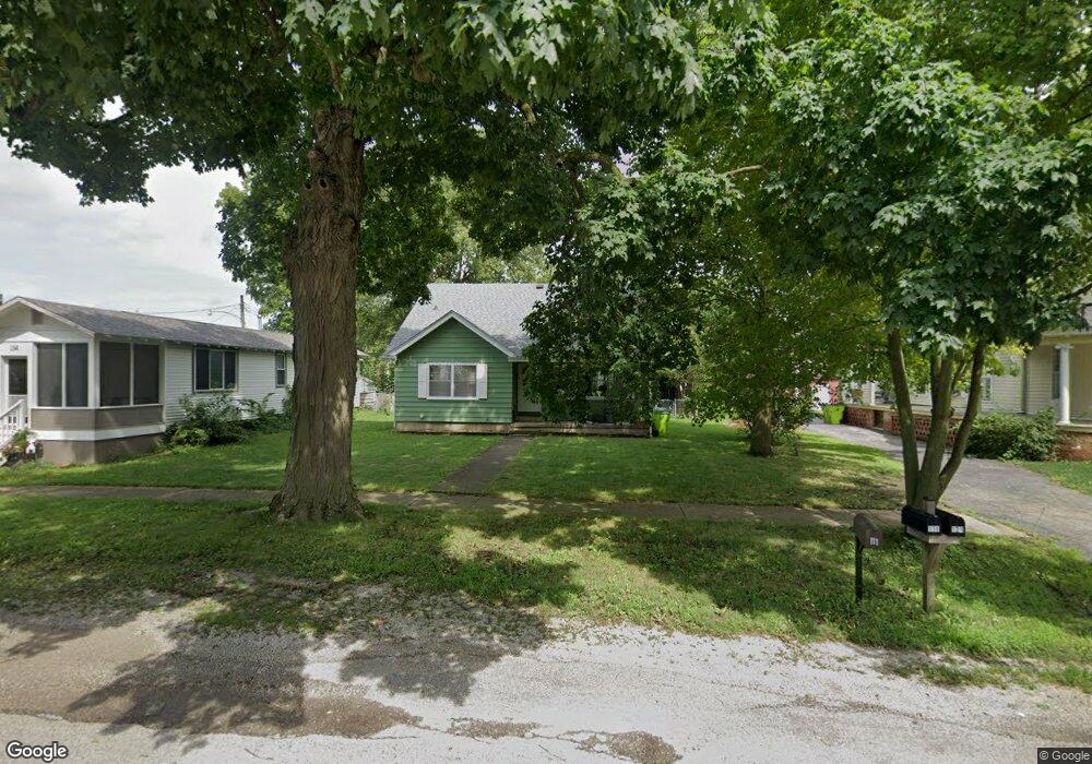
This home is located at 116 S Walnut St, Maroa, IL 61756 and is currently estimated at $128,220, approximately $109 per square foot. 116 S Walnut St is a home located in Macon County with nearby schools including Maroa-Forsyth Grade School, Maroa-Forsyth Middle School, and Maroa-Forsyth Senior High School.
Ownership History
Date
Name
Owned For
Owner Type
Purchase Details
Closed on
Aug 24, 2013
Sold by
Brooke Patricia F
Bought by
Eighner Justin A and Eighner Jill A
Current Estimated Value
Home Financials for this Owner
Home Financials are based on the most recent Mortgage that was taken out on this home.
Original Mortgage
$58,000
Outstanding Balance
$43,029
Interest Rate
4.33%
Mortgage Type
New Conventional
Estimated Equity
$85,191
Purchase Details
Closed on
Nov 1, 2001
Create a Home Valuation Report for This Property
The Home Valuation Report is an in-depth analysis detailing your home's value as well as a comparison with similar homes in the area
Purchase History
| Date | Buyer | Sale Price | Title Company |
|---|---|---|---|
| Eighner Justin A | $72,000 | None Available | |
| -- | $85,500 | -- |
Source: Public Records
Mortgage History
| Date | Status | Borrower | Loan Amount |
|---|---|---|---|
| Open | Eighner Justin A | $58,000 |
Source: Public Records
Tax History
| Year | Tax Paid | Tax Assessment Tax Assessment Total Assessment is a certain percentage of the fair market value that is determined by local assessors to be the total taxable value of land and additions on the property. | Land | Improvement |
|---|---|---|---|---|
| 2024 | $3,698 | $40,502 | $5,105 | $35,397 |
| 2023 | $3,490 | $37,635 | $4,744 | $32,891 |
| 2022 | $3,307 | $35,501 | $4,475 | $31,026 |
| 2021 | $3,203 | $33,720 | $4,250 | $29,470 |
| 2020 | $2,936 | $31,776 | $4,005 | $27,771 |
| 2019 | $2,936 | $31,776 | $4,005 | $27,771 |
| 2018 | $2,807 | $31,022 | $3,910 | $27,112 |
| 2017 | $2,936 | $31,152 | $3,926 | $27,226 |
| 2016 | $2,930 | $31,114 | $3,921 | $27,193 |
| 2015 | $2,770 | $30,208 | $3,807 | $26,401 |
| 2014 | $2,682 | $29,909 | $3,769 | $26,140 |
| 2013 | $1,712 | $29,909 | $3,769 | $26,140 |
Source: Public Records
Map
Nearby Homes
- 116 S Maple St
- 227 N Walnut St
- 214 N Maple St
- 108 N Locust St
- 2420 Lillian
- 2460 Lillian
- 2490 Lillian
- 2440 Lillian
- 2480 Lillian
- 8000 Gash Bridge Rd
- 3557 E Wise Rd
- 0 Betty Ln Unit 10514801
- 545 W Forsyth Rd
- 151 S Elwood St
- 247 S Grant St
- 760 W Forsyth Pkwy
- 5000 Silverado Ln
- 332 E Cox St
- 66 Holiday Dr
- 3 Delmar Dr
- 114 S Walnut St
- 124 S Walnut St
- 110 S Walnut St
- 130 S Walnut St
- 114 E Main St
- 121 S Walnut St
- 103 S Chestnut St
- 111 S Walnut St
- 220 E Main St
- 125 S Walnut St
- 131 S Walnut St
- 200 S Walnut St
- 109 E Main St
- 201 S Walnut St
- 111 N Hickory St
- 116 W Main St
- 201 E Main St
- 212 S Walnut St
- 117 W Lincoln St
- 107 N Walnut St
Your Personal Tour Guide
Ask me questions while you tour the home.