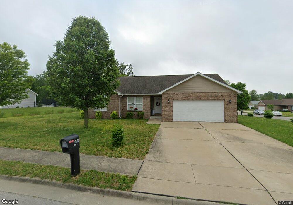
116 Tall Maple Ct Freeburg, IL 62243
Estimated Value: $289,000 - $344,000
--
Bed
--
Bath
1,681
Sq Ft
$186/Sq Ft
Est. Value
About This Home
This home is located at 116 Tall Maple Ct, Freeburg, IL 62243 and is currently estimated at $313,185, approximately $186 per square foot. 116 Tall Maple Ct is a home located in St. Clair County with nearby schools including Freeburg Elementary School, Freeburg Community High School, and St. Joseph Catholic School.
Ownership History
Date
Name
Owned For
Owner Type
Purchase Details
Closed on
Dec 29, 2021
Sold by
Johns Jay D and Johns Marcie A
Bought by
Johns Jay D and Johns Marcie A
Current Estimated Value
Purchase Details
Closed on
Jul 29, 2009
Sold by
Estates At Woods Edge Llc
Bought by
Johns Iii Jay D and Johns Marcie A
Home Financials for this Owner
Home Financials are based on the most recent Mortgage that was taken out on this home.
Original Mortgage
$175,750
Outstanding Balance
$119,116
Interest Rate
6%
Mortgage Type
Construction
Estimated Equity
$194,069
Create a Home Valuation Report for This Property
The Home Valuation Report is an in-depth analysis detailing your home's value as well as a comparison with similar homes in the area
Home Values in the Area
Average Home Value in this Area
Purchase History
| Date | Buyer | Sale Price | Title Company |
|---|---|---|---|
| Johns Jay D | -- | Attorney | |
| Johns Iii Jay D | $36,000 | Benchmark Title Company Llc |
Source: Public Records
Mortgage History
| Date | Status | Borrower | Loan Amount |
|---|---|---|---|
| Open | Johns Iii Jay D | $175,750 |
Source: Public Records
Tax History Compared to Growth
Tax History
| Year | Tax Paid | Tax Assessment Tax Assessment Total Assessment is a certain percentage of the fair market value that is determined by local assessors to be the total taxable value of land and additions on the property. | Land | Improvement |
|---|---|---|---|---|
| 2024 | $6,234 | $80,553 | $14,056 | $66,497 |
| 2023 | $6,047 | $77,310 | $13,565 | $63,745 |
| 2022 | $5,758 | $72,442 | $12,711 | $59,731 |
| 2021 | $5,547 | $68,200 | $11,967 | $56,233 |
| 2020 | $5,265 | $62,045 | $10,887 | $51,158 |
| 2019 | $5,290 | $64,913 | $11,253 | $53,660 |
| 2018 | $5,195 | $64,054 | $11,104 | $52,950 |
| 2017 | $4,949 | $61,243 | $10,617 | $50,626 |
| 2016 | $4,886 | $58,695 | $10,175 | $48,520 |
| 2014 | $2,125 | $57,891 | $10,441 | $47,450 |
| 2013 | $4,043 | $57,375 | $10,348 | $47,027 |
Source: Public Records
Map
Nearby Homes
- 520 N Edison St
- 428 Firestone St
- 701 N Edison St
- 207 N Edison St
- 515 N Main St
- 106 N State St
- 302 N Railroad St
- 206 N Main St
- 3 N Richland St
- 4 N West St
- 508 S State St
- 440 Foxtail Dr
- 7 Lakeview Dr
- 420 Foxtail Dr
- 433 Foxtail Dr
- 421 Foxtail Dr
- 502 Draco Dr
- 0 Hickory Dr
- 103 Draco Dr
- 363 Sleeping Indian Dr
- 110 Tall Maple Ct
- 117 Tall Maple Ct
- 512 Creek Ridge Ct
- 121 Tall Maple Ct
- 113 Tall Maple Ct
- 120 Tall Maple Ct
- 124 Tall Maple Ct
- 513 Creek Ridge Ct
- 125 Tall Maple Ct
- 508 Creek Ridge Ct
- 109 Tall Maple Ct
- 420 Firestone St
- 509 Creek Ridge Ct
- 416 Firestone St
- 412 Firestone St
- 530 N Edison St Unit L
- 530 N Edison St Unit 530
- 528 N Edison St Unit M
- 528 N Edison St
- 504 Creek Ridge Ct