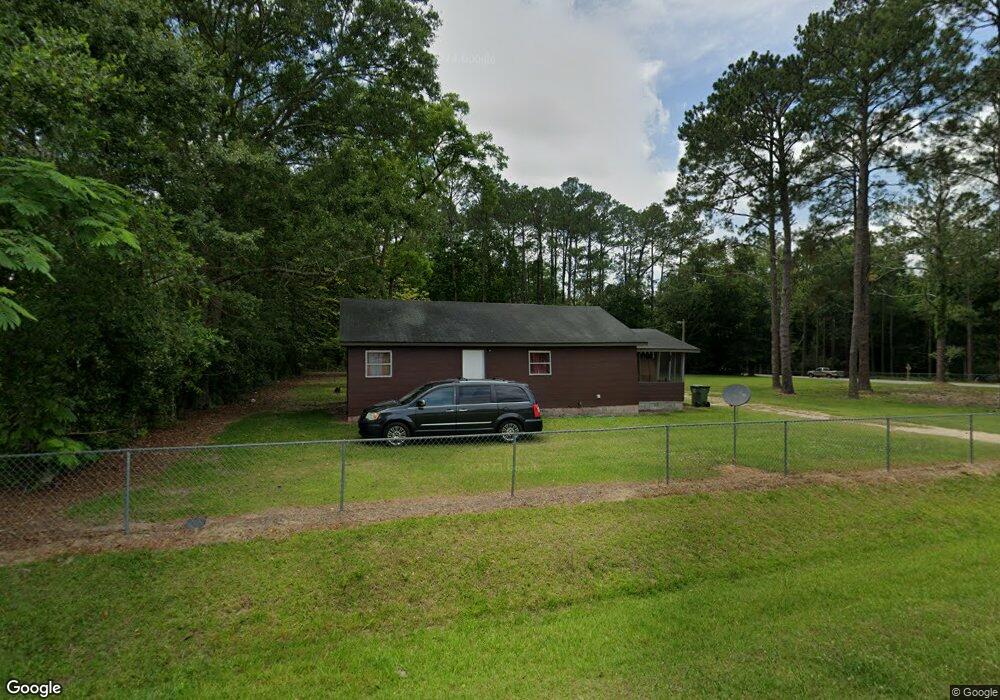
116 Thompson Rd Moultrie, GA 31788
Estimated Value: $93,000 - $109,000
Studio
1
Bath
1,206
Sq Ft
$87/Sq Ft
Est. Value
About This Home
This home is located at 116 Thompson Rd, Moultrie, GA 31788 and is currently estimated at $104,500, approximately $86 per square foot. 116 Thompson Rd is a home located in Colquitt County with nearby schools including Cox Elementary School, Willie J. Williams Middle School, and C.A. Gray Junior High School.
Ownership History
Date
Name
Owned For
Owner Type
Purchase Details
Closed on
May 18, 2017
Sold by
Hancock Wayne S
Bought by
Guzman Ignacio
Current Estimated Value
Home Financials for this Owner
Home Financials are based on the most recent Mortgage that was taken out on this home.
Original Mortgage
$26,500
Interest Rate
3.97%
Mortgage Type
New Conventional
Purchase Details
Closed on
Jan 29, 2003
Sold by
Gurley Richard L
Bought by
Hancock Wayne S
Purchase Details
Closed on
Dec 15, 1997
Bought by
Gurley Richard L
Create a Home Valuation Report for This Property
The Home Valuation Report is an in-depth analysis detailing your home's value as well as a comparison with similar homes in the area
Purchase History
| Date | Buyer | Sale Price | Title Company |
|---|---|---|---|
| Guzman Ignacio | $26,500 | -- | |
| Hancock Wayne S | $28,400 | -- | |
| Gurley Richard L | $30,000 | -- |
Source: Public Records
Mortgage History
| Date | Status | Borrower | Loan Amount |
|---|---|---|---|
| Closed | Guzman Ignacio | $26,500 |
Source: Public Records
Tax History
| Year | Tax Paid | Tax Assessment Tax Assessment Total Assessment is a certain percentage of the fair market value that is determined by local assessors to be the total taxable value of land and additions on the property. | Land | Improvement |
|---|---|---|---|---|
| 2025 | $433 | $21,784 | $2,312 | $19,472 |
| 2024 | $433 | $20,214 | $1,734 | $18,480 |
| 2023 | $426 | $12,820 | $1,734 | $11,086 |
| 2022 | $291 | $12,210 | $1,542 | $10,668 |
| 2021 | $325 | $13,378 | $1,542 | $11,836 |
| 2020 | $315 | $12,730 | $1,542 | $11,188 |
| 2019 | $353 | $12,838 | $1,542 | $11,296 |
| 2018 | $328 | $12,838 | $1,542 | $11,296 |
| 2017 | $378 | $13,872 | $2,440 | $11,432 |
| 2016 | $383 | $13,872 | $2,440 | $11,432 |
| 2015 | $386 | $13,872 | $2,440 | $11,432 |
| 2014 | $379 | $13,872 | $2,440 | $11,432 |
| 2013 | -- | $13,872 | $2,440 | $11,431 |
Source: Public Records
Map
Nearby Homes
- 292 Robin Ln
- 0 Sardis Church Rd Unit 146687
- 150 Friendship Trail
- 235 Riggins Rd
- 410 Indian Trail
- 0 Old Timey Trail
- 2754 Tallokas Rd
- 2129 E Central Ave
- 0 Tallokas Rd Unit 11663248
- 1717 Park Ave SE
- 144 Flint Dr
- 3208 Tallokas Rd
- 31 31st Ave SE
- 1701 10th St SE
- 1117 11th Ave SE
- 1820 10th St SE
- 216 Circle Dr
- 237 Lakeside Dr NE
- 1111 10th Ave SE
- 198 Lindale Ave
- 126 Thompson Rd
- 196 Sardis Church Rd
- 223 Sardis Church Rd
- 155 Thompson Rd
- 246 Sardis Church Rd
- 247 Sardis Church Rd
- 158 Thompson Rd
- 000 Sardis Church Rd
- 143 Stiner Rd
- 122 Stiner Rd
- 155 Ewer Rd
- 166 Thompson Rd
- 263 Sardis Church Rd
- 196 Beaty Rd
- 286 Sardis Church Rd
- 131 Stiner Rd
- 123 Stiner Rd
- 139 Ewer Rd
- 184 Thompson Rd
- 146 Ewer Rd
Your Personal Tour Guide
Ask me questions while you tour the home.