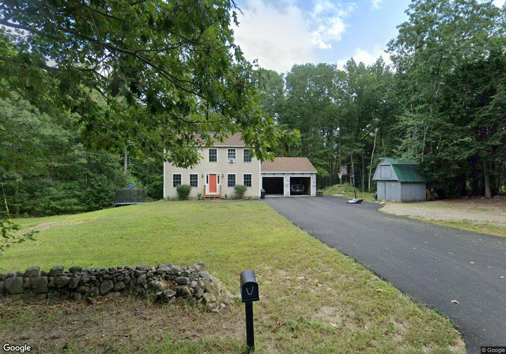
116 Upper Tarbox Rd Hollis Center, ME 04042
Estimated Value: $358,000 - $460,000
2
Beds
1
Bath
1,088
Sq Ft
$378/Sq Ft
Est. Value
About This Home
This home is located at 116 Upper Tarbox Rd, Hollis Center, ME 04042 and is currently estimated at $411,477, approximately $378 per square foot. 116 Upper Tarbox Rd is a home located in York County with nearby schools including Bonny Eagle High School.
Ownership History
Date
Name
Owned For
Owner Type
Purchase Details
Closed on
Aug 25, 2017
Sold by
Sturgis Trisha A and Sturgis Chad E
Bought by
Sturgis Chad E and Sturgis Trisha A
Current Estimated Value
Home Financials for this Owner
Home Financials are based on the most recent Mortgage that was taken out on this home.
Original Mortgage
$184,600
Outstanding Balance
$141,974
Interest Rate
4.03%
Mortgage Type
Unknown
Estimated Equity
$269,504
Purchase Details
Closed on
Jun 19, 2007
Sold by
Estabrook Cynthia J and Sturgis Gregory F
Bought by
Sturgis Chad E and Shaw Trisha A
Home Financials for this Owner
Home Financials are based on the most recent Mortgage that was taken out on this home.
Original Mortgage
$186,856
Interest Rate
6.48%
Mortgage Type
Unknown
Create a Home Valuation Report for This Property
The Home Valuation Report is an in-depth analysis detailing your home's value as well as a comparison with similar homes in the area
Home Values in the Area
Average Home Value in this Area
Purchase History
| Date | Buyer | Sale Price | Title Company |
|---|---|---|---|
| Sturgis Chad E | -- | -- | |
| Sturgis Chad E | -- | -- |
Source: Public Records
Mortgage History
| Date | Status | Borrower | Loan Amount |
|---|---|---|---|
| Open | Sturgis Chad E | $184,600 | |
| Closed | Sturgis Chad E | $25,000 | |
| Closed | Sturgis Chad E | $186,856 | |
| Closed | Sturgis Chad E | $186,856 | |
| Closed | Sturgis Chad E | $186,856 |
Source: Public Records
Tax History
| Year | Tax Paid | Tax Assessment Tax Assessment Total Assessment is a certain percentage of the fair market value that is determined by local assessors to be the total taxable value of land and additions on the property. | Land | Improvement |
|---|---|---|---|---|
| 2025 | $3,296 | $219,700 | $57,100 | $162,600 |
| 2024 | $3,296 | $219,700 | $57,100 | $162,600 |
| 2023 | $3,186 | $219,700 | $57,100 | $162,600 |
| 2022 | $3,129 | $208,600 | $57,100 | $151,500 |
| 2021 | $2,758 | $193,560 | $57,120 | $136,440 |
| 2020 | $2,710 | $193,560 | $57,120 | $136,440 |
| 2019 | $2,661 | $193,560 | $57,120 | $136,440 |
| 2018 | $2,565 | $193,560 | $57,120 | $136,440 |
| 2017 | $2,420 | $193,560 | $57,120 | $136,440 |
| 2016 | $2,313 | $193,560 | $57,120 | $136,440 |
| 2015 | $2,313 | $193,560 | $57,120 | $136,440 |
| 2014 | $2,226 | $193,560 | $57,120 | $136,440 |
| 2013 | $1,950 | $177,240 | $57,120 | $120,120 |
Source: Public Records
Map
Nearby Homes
- 19 Frank Savage Rd
- 107 Lower Tarbox Rd
- 47 Landry Dr
- 252 Plains Rd
- 25 Adirondack Dr
- 1102 Cape Rd
- 433 Plains Rd
- 19 Old Limerick Rd
- 12 Totem Pines Dr
- 756 Deering Ridge Rd
- 37 High St
- 807 Deering Ridge Rd
- 29-006A Joseph Way
- 2 Bonny Eagle Rd
- 4 Moderation St
- 4 Pelletier Dr
- 53 Cape Rd
- 55 Joseph Way
- 668 Hollis Rd
- 8 Whittens Ln
- 106 Upper Tarbox Rd
- 122 Upper Tarbox Rd
- 121 Upper Tarbox Rd
- 107 Upper Tarbox Rd
- 45 Meserve Ln
- 137 Upper Tarbox Rd
- 94 Upper Tarbox Rd
- 97 Upper Tarbox Rd
- 84 Upper Tarbox Rd
- 142 Upper Tarbox Rd
- 78 Upper Tarbox Rd
- 81 Upper Tarbox Rd
- 744 Cape Rd
- 21 Hillside Dr
- 17 Murphy Ln
- 15 Murphy Ln
- 68 Upper Tarbox Rd
- 3 Meserve Ln
- 29 Meserve Ln
- 736 Cape Rd
Your Personal Tour Guide
Ask me questions while you tour the home.