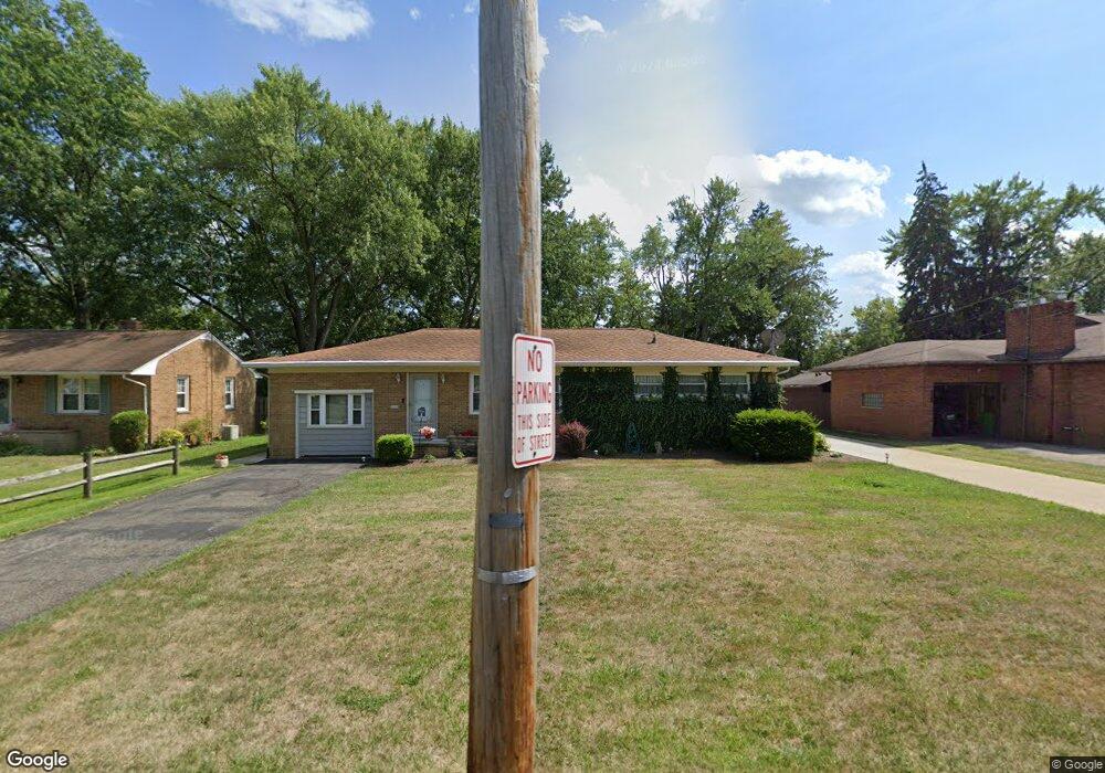
116 W Grant St Alliance, OH 44601
Estimated Value: $145,000 - $181,630
3
Beds
1
Bath
1,248
Sq Ft
$133/Sq Ft
Est. Value
About This Home
This home is located at 116 W Grant St, Alliance, OH 44601 and is currently estimated at $166,158, approximately $133 per square foot. 116 W Grant St is a home located in Stark County with nearby schools including Alliance Early Learning School, Alliance Intermediate School at Northside, and Alliance Middle School.
Ownership History
Date
Name
Owned For
Owner Type
Purchase Details
Closed on
Oct 3, 2023
Sold by
Schafer Robert J and Schafer Kathaleen E
Bought by
Schafer Jeffrey R and Schafer Jay R
Current Estimated Value
Purchase Details
Closed on
Mar 8, 2007
Sold by
Conrad Kyle and Conrad Linda K
Bought by
Schafer Robert J and Schafer Kathaleen E
Home Financials for this Owner
Home Financials are based on the most recent Mortgage that was taken out on this home.
Original Mortgage
$66,400
Interest Rate
6.28%
Mortgage Type
Purchase Money Mortgage
Create a Home Valuation Report for This Property
The Home Valuation Report is an in-depth analysis detailing your home's value as well as a comparison with similar homes in the area
Home Values in the Area
Average Home Value in this Area
Purchase History
| Date | Buyer | Sale Price | Title Company |
|---|---|---|---|
| Schafer Jeffrey R | -- | None Listed On Document | |
| Schafer Robert J | $83,500 | Attorney |
Source: Public Records
Mortgage History
| Date | Status | Borrower | Loan Amount |
|---|---|---|---|
| Previous Owner | Schafer Robert J | $66,400 |
Source: Public Records
Tax History Compared to Growth
Tax History
| Year | Tax Paid | Tax Assessment Tax Assessment Total Assessment is a certain percentage of the fair market value that is determined by local assessors to be the total taxable value of land and additions on the property. | Land | Improvement |
|---|---|---|---|---|
| 2025 | -- | $50,790 | $14,740 | $36,050 |
| 2024 | -- | $50,790 | $14,740 | $36,050 |
| 2023 | $1,523 | $37,910 | $13,760 | $24,150 |
| 2022 | $1,536 | $37,980 | $13,760 | $24,220 |
| 2021 | $1,502 | $37,980 | $13,760 | $24,220 |
| 2020 | $1,429 | $32,970 | $11,970 | $21,000 |
| 2019 | $1,409 | $32,970 | $11,970 | $21,000 |
| 2018 | $1,416 | $32,970 | $11,970 | $21,000 |
| 2017 | $1,287 | $29,480 | $9,660 | $19,820 |
| 2016 | $1,151 | $26,150 | $9,660 | $16,490 |
| 2015 | $1,161 | $26,150 | $9,660 | $16,490 |
| 2014 | $1,242 | $26,650 | $9,840 | $16,810 |
| 2013 | $494 | $21,220 | $8,230 | $12,990 |
Source: Public Records
Map
Nearby Homes
- 807 S Union Ave
- 140 W Summit St
- 427 S Union Ave
- 645 W Summit St
- 725 W Summit St
- 452 E Summit St
- 734 Parkway Blvd
- 738 Kingsway St
- 132 S Haines Ave
- 1005 S Freedom Ave
- 896 Parkway Blvd
- 1475 Chatauqua Ct
- 432 S Linden Ave
- 1175 S Freedom Ave
- 163 W Market St
- 356 E Broadway St
- 1437 S Linden Ave
- 345 W Market St
- V/L S Fredeom Ave
- 551 South St
- 100 W Grant St
- 130 W Grant St
- 78 W Grant St
- 144 W Grant St
- 101 W Grant St
- 68 W Grant St
- 68 W Grant St
- 154 W Grant St
- 135 W Grant St
- 147 W Grant St
- 770 Scranton Ave
- 200 W Grant St
- 765 Scranton Ave
- 69 W Grant St
- 111 Glamorgan St Unit B11
- 111 Glamorgan St Unit 205
- 111 Glamorgan St Unit B5
- 111 Glamorgan St Unit 109
- 111 Glamorgan St Unit 108
- 111 Glamorgan St Unit 207