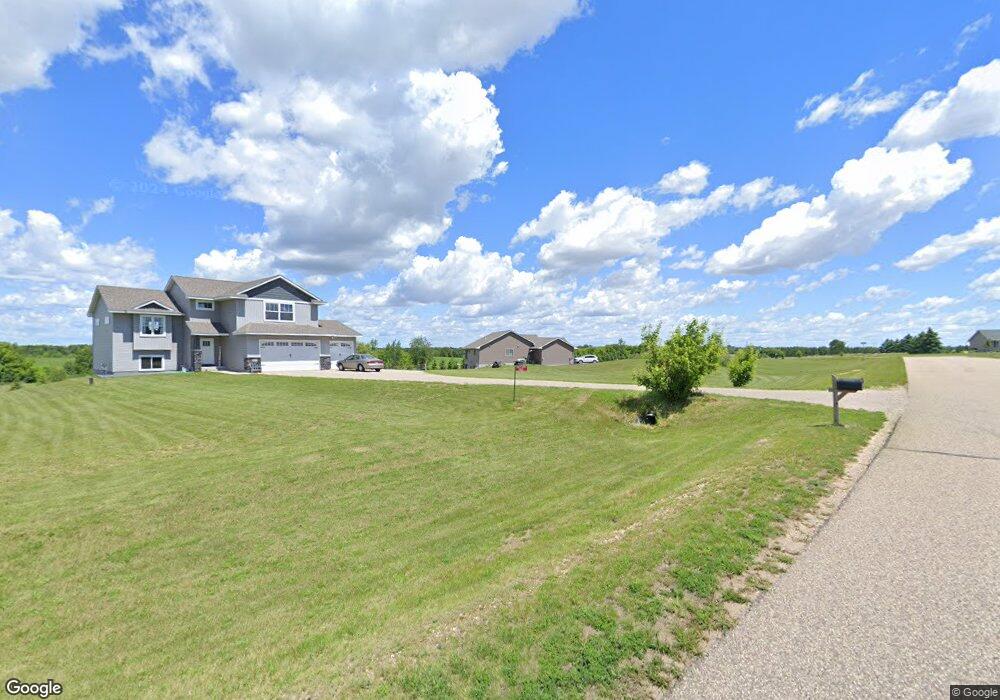
1160 134th Ave New Richmond, WI 54017
Richmond NeighborhoodEstimated Value: $398,000 - $483,000
3
Beds
2
Baths
--
Sq Ft
1.67
Acres
About This Home
This home is located at 1160 134th Ave, New Richmond, WI 54017 and is currently estimated at $438,483. 1160 134th Ave is a home located in St. Croix County with nearby schools including New Richmond High School.
Ownership History
Date
Name
Owned For
Owner Type
Purchase Details
Closed on
Apr 26, 2019
Sold by
Oevering Homes Llc
Bought by
Bjornstad Gregory J
Current Estimated Value
Home Financials for this Owner
Home Financials are based on the most recent Mortgage that was taken out on this home.
Original Mortgage
$274,339
Outstanding Balance
$241,443
Interest Rate
4.25%
Mortgage Type
FHA
Estimated Equity
$197,040
Purchase Details
Closed on
Jun 27, 2014
Sold by
Richmond Acres Llc
Bought by
Oevering Homes Llc
Home Financials for this Owner
Home Financials are based on the most recent Mortgage that was taken out on this home.
Original Mortgage
$247,100
Interest Rate
4.11%
Mortgage Type
Commercial
Create a Home Valuation Report for This Property
The Home Valuation Report is an in-depth analysis detailing your home's value as well as a comparison with similar homes in the area
Home Values in the Area
Average Home Value in this Area
Purchase History
| Date | Buyer | Sale Price | Title Company |
|---|---|---|---|
| Bjornstad Gregory J | $279,400 | Abstracts & Titles | |
| Oevering Homes Llc | $275,000 | St Croix County Abstract & T |
Source: Public Records
Mortgage History
| Date | Status | Borrower | Loan Amount |
|---|---|---|---|
| Open | Bjornstad Gregory J | $274,339 | |
| Previous Owner | Oevering Homes Llc | $247,100 |
Source: Public Records
Tax History Compared to Growth
Tax History
| Year | Tax Paid | Tax Assessment Tax Assessment Total Assessment is a certain percentage of the fair market value that is determined by local assessors to be the total taxable value of land and additions on the property. | Land | Improvement |
|---|---|---|---|---|
| 2024 | $41 | $330,900 | $42,100 | $288,800 |
| 2023 | $3,767 | $330,900 | $42,100 | $288,800 |
| 2022 | $3,268 | $330,900 | $42,100 | $288,800 |
| 2021 | $3,162 | $330,900 | $42,100 | $288,800 |
| 2020 | $2,010 | $203,700 | $20,700 | $183,000 |
| 2019 | $5 | $113,400 | $20,700 | $92,700 |
| 2018 | $5 | $300 | $300 | $0 |
| 2017 | $5 | $300 | $300 | $0 |
| 2016 | $5 | $300 | $300 | $0 |
| 2015 | $5 | $300 | $300 | $0 |
| 2014 | $5 | $300 | $300 | $0 |
| 2013 | $5 | $300 | $300 | $0 |
Source: Public Records
Map
Nearby Homes
- 1438 129th St
- 1101 148th Ave
- 1193 121st St
- TBD 119th Ave
- 1318 146th Ave
- 943 146th Ave
- 906 131st Ave
- 1448 142nd St
- 1295 110th Ave
- 1417 146th Ave
- 1824 White Pine Way
- 1002 159th Ave
- 1764 Sequoia Ln
- 1149 Sugar Pine Ln
- 1137 Sugar Pine Ln
- 1957 Cattail Place Unit Lot 7
- TBD Cattail Ln Unit Lot 8
- TBD Cattail Ln Unit Lot 9
- 1622 100th St
- 1565 Ponderosa Ln