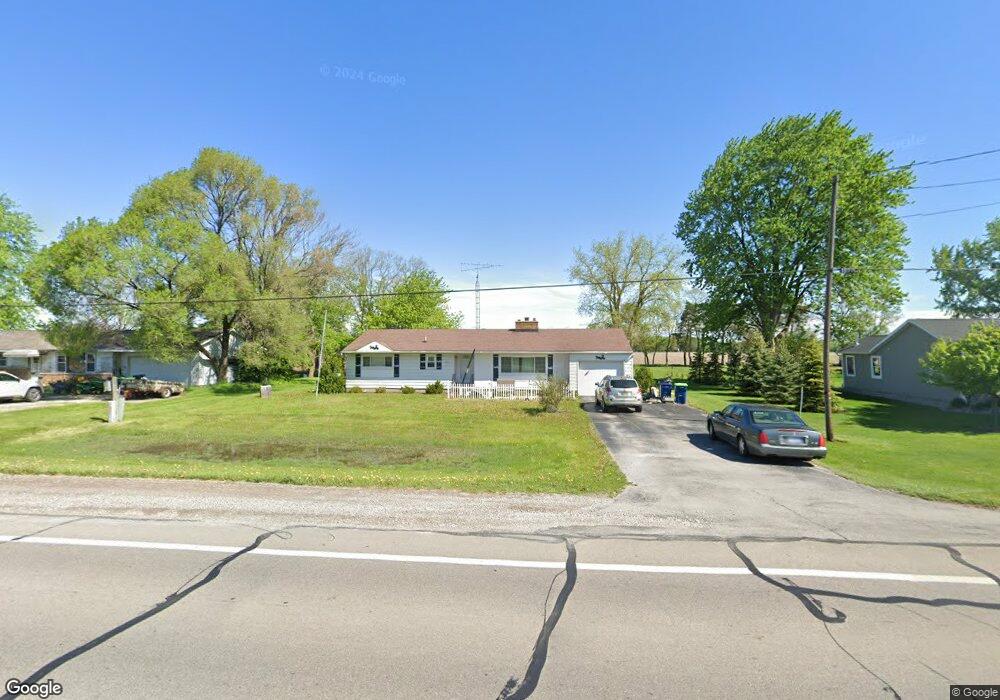
11600 Brady Rd Chesaning, MI 48616
Estimated Value: $171,000 - $199,000
3
Beds
2
Baths
1,504
Sq Ft
$123/Sq Ft
Est. Value
About This Home
This home is located at 11600 Brady Rd, Chesaning, MI 48616 and is currently estimated at $184,910, approximately $122 per square foot. 11600 Brady Rd is a home located in Saginaw County with nearby schools including Big Rock Elementary School, Chesaning Middle School, and Chesaning Union High School.
Ownership History
Date
Name
Owned For
Owner Type
Purchase Details
Closed on
Jun 18, 2020
Sold by
Smith Kerry
Bought by
Smith Kerry and Smith Kimberly
Current Estimated Value
Purchase Details
Closed on
Apr 7, 2020
Sold by
Wesley William J and Fred & Wilma Wesley Trust
Bought by
Smith Kerry
Home Financials for this Owner
Home Financials are based on the most recent Mortgage that was taken out on this home.
Original Mortgage
$127,272
Outstanding Balance
$112,748
Interest Rate
3.4%
Mortgage Type
New Conventional
Estimated Equity
$72,162
Purchase Details
Closed on
Jul 30, 2018
Sold by
Wesley Fred A
Bought by
Fred and Fred Wesley T
Create a Home Valuation Report for This Property
The Home Valuation Report is an in-depth analysis detailing your home's value as well as a comparison with similar homes in the area
Home Values in the Area
Average Home Value in this Area
Purchase History
| Date | Buyer | Sale Price | Title Company |
|---|---|---|---|
| Smith Kerry | -- | None Available | |
| Smith Kerry | $126,000 | None Available | |
| Fred | -- | -- |
Source: Public Records
Mortgage History
| Date | Status | Borrower | Loan Amount |
|---|---|---|---|
| Open | Smith Kerry | $127,272 |
Source: Public Records
Tax History Compared to Growth
Tax History
| Year | Tax Paid | Tax Assessment Tax Assessment Total Assessment is a certain percentage of the fair market value that is determined by local assessors to be the total taxable value of land and additions on the property. | Land | Improvement |
|---|---|---|---|---|
| 2025 | $2,378 | $82,200 | $0 | $0 |
| 2024 | $710 | $78,100 | $0 | $0 |
| 2023 | $676 | $69,200 | $0 | $0 |
| 2022 | $2,121 | $63,500 | $0 | $0 |
| 2021 | $1,943 | $56,900 | $0 | $0 |
| 2020 | $1,691 | $57,600 | $0 | $0 |
| 2019 | $1,618 | $56,200 | $4,100 | $52,100 |
| 2018 | $521 | $52,000 | $0 | $0 |
| 2017 | $1,457 | $50,100 | $0 | $0 |
| 2016 | $1,441 | $49,000 | $0 | $0 |
| 2014 | -- | $49,200 | $0 | $0 |
| 2013 | -- | $49,200 | $0 | $0 |
Source: Public Records
Map
Nearby Homes
- 16395 Frandsche Rd
- 910 W Brady Rd
- V/L W Liberty St
- 0 N 4th St
- 887 N 4th St
- V/L #4 Brookshire Dr
- V/L #5 Brookshire Dr
- 12490 W Brady Rd
- 0 N 1st St
- 829 Brady St
- 0 Arrowhead 1-A Dr Unit 50184284
- 0 Arrowhead 1-A Dr Unit 50184274
- 202 S Clark St
- 600 Bentley St
- 317 S Clark St
- 423 S Line St
- 128 Pearl St
- 300 Brady St
- 1017 N Line St
- 201 Mason St