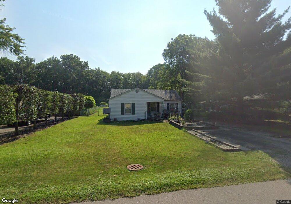
11617 Cape Cod St Taylor, MI 48180
Estimated Value: $175,396 - $221,000
Studio
--
Bath
1,193
Sq Ft
$171/Sq Ft
Est. Value
About This Home
This home is located at 11617 Cape Cod St, Taylor, MI 48180 and is currently estimated at $204,349, approximately $171 per square foot. 11617 Cape Cod St is a home located in Wayne County with nearby schools including Holland Elementary School, Hoover Middle School, and Taylor High School.
Ownership History
Date
Name
Owned For
Owner Type
Purchase Details
Closed on
Nov 18, 2025
Sold by
Kish Jerri
Bought by
Kish Jerri Devonia and Kish Rutha Brandi
Current Estimated Value
Purchase Details
Closed on
Apr 24, 2025
Sold by
Kish Steven J
Bought by
Kish Jerri
Purchase Details
Closed on
Sep 20, 2004
Sold by
Kamin Jerri D and Kish Jerri D
Bought by
Kish Steven J
Home Financials for this Owner
Home Financials are based on the most recent Mortgage that was taken out on this home.
Original Mortgage
$103,500
Interest Rate
5.8%
Mortgage Type
New Conventional
Purchase Details
Closed on
Nov 26, 2002
Sold by
Kamin Robert Louis
Bought by
Kamin Jerri Devonia
Create a Home Valuation Report for This Property
The Home Valuation Report is an in-depth analysis detailing your home's value as well as a comparison with similar homes in the area
Home Values in the Area
Average Home Value in this Area
Purchase History
| Date | Buyer | Sale Price | Title Company |
|---|---|---|---|
| Kish Jerri Devonia | -- | None Listed On Document | |
| Kish Jerri | -- | None Listed On Document | |
| Kish Steven J | -- | Devon Title Agency | |
| Kamin Jerri Devonia | -- | Devon Title Agency |
Source: Public Records
Mortgage History
| Date | Status | Borrower | Loan Amount |
|---|---|---|---|
| Previous Owner | Kish Steven J | $103,500 |
Source: Public Records
Tax History
| Year | Tax Paid | Tax Assessment Tax Assessment Total Assessment is a certain percentage of the fair market value that is determined by local assessors to be the total taxable value of land and additions on the property. | Land | Improvement |
|---|---|---|---|---|
| 2025 | $1,813 | $87,100 | $0 | $0 |
| 2024 | $1,756 | $76,700 | $0 | $0 |
| 2023 | $1,675 | $69,700 | $0 | $0 |
| 2022 | $1,675 | $59,400 | $0 | $0 |
| 2021 | $1,990 | $56,800 | $0 | $0 |
| 2020 | $1,972 | $53,100 | $0 | $0 |
| 2019 | $233,857 | $53,300 | $0 | $0 |
| 2018 | $1,439 | $40,000 | $0 | $0 |
| 2017 | $794 | $35,600 | $0 | $0 |
| 2016 | $1,791 | $34,700 | $0 | $0 |
| 2015 | $3,251 | $41,600 | $0 | $0 |
| 2013 | $3,149 | $34,100 | $0 | $0 |
| 2012 | $1,143 | $33,800 | $16,000 | $17,800 |
Source: Public Records
Map
Nearby Homes
- 11825 Partridge Dr Unit 74
- 11847 Partridge Dr Unit 75
- 11715 Partridge Dr Unit 69
- 11737 Partridge Dr Unit 70
- 11890 Partridge Dr Unit 91
- 11516 Pheasant Cir
- 11693 Partridge Dr Unit 38
- 11693 Partridge Dr
- 26400 Partridge Dr Unit 88
- 11216 Cape Cod St
- 26376 Partridge Dr Unit 89
- 11098 Partridge Dr Unit 12
- 11098 Partridge Dr
- Bayberry Plan at Cypress Garden
- Bannister Plan at Cypress Garden
- Cypress Plan at Cypress Garden
- Evanston IV Plan at Cypress Garden
- Cedar III Plan at Cypress Garden
- Aspen Plan at Cypress Garden
- Evanston III Plan at Cypress Garden
- 11629 Cape Cod St
- 11605 Cape Cod St
- 11593 Cape Cod St
- 11815 Cape Cod St
- 11835 Cape Cod St
- 11583 Cape Cod St
- 11620 Cape Cod St
- 11608 Cape Cod St
- 11571 Cape Cod St
- 11875 Cape Cod St
- 11820 Cape Cod St
- 11586 Cape Cod St
- 11549 Cape Cod St
- 11921 Cape Cod St
- 11578 Cape Cod St
- 11634 Cape Cod St
- 11596 Cape Cod St
- 11515 Cape Cod St
- 11554 Cape Cod St
- 11840 Cape Cod St
Your Personal Tour Guide
Ask me questions while you tour the home.