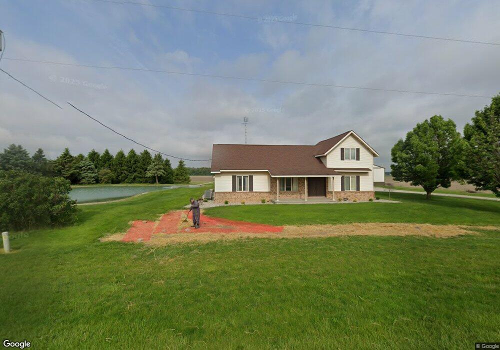
11628 Def Henry Co Line Rd Holgate, OH 43527
Estimated Value: $208,000 - $260,001
4
Beds
2
Baths
2,348
Sq Ft
$96/Sq Ft
Est. Value
About This Home
This home is located at 11628 Def Henry Co Line Rd, Holgate, OH 43527 and is currently estimated at $226,500, approximately $96 per square foot. 11628 Def Henry Co Line Rd is a home located in Defiance County with nearby schools including Ayersville Elementary School and Ayersville High School.
Ownership History
Date
Name
Owned For
Owner Type
Purchase Details
Closed on
Aug 18, 2018
Sold by
Groll Randall L and Groll Diana L
Bought by
Groll Michael L and Wright Michelle L
Current Estimated Value
Purchase Details
Closed on
Jun 7, 2010
Sold by
Groll Randall L and Groll Diana L
Bought by
Groll Randall L
Purchase Details
Closed on
Mar 8, 2005
Sold by
Groll Alvera Mae and Groll Lloyd
Bought by
Groll Randall L and Groll Diana L
Create a Home Valuation Report for This Property
The Home Valuation Report is an in-depth analysis detailing your home's value as well as a comparison with similar homes in the area
Home Values in the Area
Average Home Value in this Area
Purchase History
| Date | Buyer | Sale Price | Title Company |
|---|---|---|---|
| Groll Michael L | -- | None Available | |
| Groll Diana L | -- | None Available | |
| Groll Randall L | -- | None Available | |
| Groll Randall L | -- | -- | |
| Groll Randall L | -- | None Available |
Source: Public Records
Tax History Compared to Growth
Tax History
| Year | Tax Paid | Tax Assessment Tax Assessment Total Assessment is a certain percentage of the fair market value that is determined by local assessors to be the total taxable value of land and additions on the property. | Land | Improvement |
|---|---|---|---|---|
| 2024 | $2,417 | $65,100 | $6,570 | $58,530 |
| 2023 | $2,417 | $65,100 | $6,570 | $58,530 |
| 2022 | $2,561 | $57,670 | $6,010 | $51,660 |
| 2021 | $2,561 | $57,670 | $6,010 | $51,660 |
| 2020 | $2,610 | $57,670 | $6,010 | $51,660 |
| 2019 | $1,839 | $49,840 | $5,920 | $43,920 |
| 2018 | $1,832 | $49,840 | $5,920 | $43,920 |
| 2017 | $1,810 | $49,833 | $5,915 | $43,918 |
| 2016 | $1,885 | $43,271 | $5,705 | $37,566 |
| 2015 | $892 | $43,271 | $5,705 | $37,566 |
| 2014 | $892 | $43,880 | $5,705 | $38,175 |
| 2013 | $892 | $43,880 | $5,705 | $38,175 |
| 2012 | $892 | $43,880 | $5,705 | $38,175 |
Source: Public Records
Map
Nearby Homes
- H011 County Road 17
- 28618 Steinmaier Rd
- 407 W High St
- 104 E High St
- 104 W High St
- 30260 Jewell Rd
- 27824 Ayersville Pleasant Bend Rd
- 28916 Blanchard Rd
- 27600 Jewell Rd
- 215 Cherry St
- 16052 State Route 424
- 422 N Wilhelm St
- 0 Domersville Rd
- 1459 Deerwood Dr
- 1820 Ayersville Ave
- 846 Deerwood Dr
- 850 Deerwood Dr
- 1365 Heatherdowns Dr
- 1408 Heatherdowns Dr
- 649 Burning Tree Dr
- 510 County Road 19
- H510 County Road 19
- 11820 Def Henry Co Line Rd
- 11976 Def Henry Co Line Rd
- 18992 County Road H
- 18941 County Road H
- 11994 Def Henry Co Line Rd
- 18922 County Road H
- 18974 County Road H
- 18832 County Road H
- 18943 County Road H
- 30773 Standley Rd
- 30753 Standley Rd
- G968 County Road 19
- 936 County Road 19
- 30705 Standley Rd
- G936 County Road 19
- G936 County Road 19
- 30671 Standley Rd
- 11172 Def Henry Co Line Rd