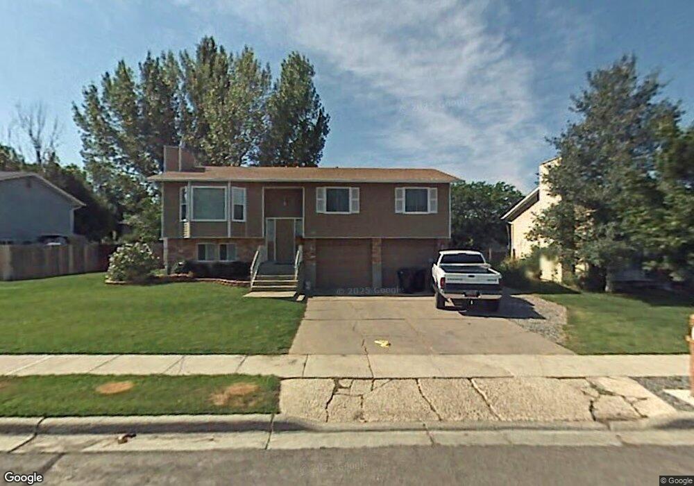
1163 W 1850 S Woods Cross, UT 84087
Estimated Value: $471,000 - $493,000
3
Beds
2
Baths
1,748
Sq Ft
$276/Sq Ft
Est. Value
About This Home
This home is located at 1163 W 1850 S, Woods Cross, UT 84087 and is currently estimated at $482,668, approximately $276 per square foot. 1163 W 1850 S is a home located in Davis County with nearby schools including Woods Cross Elementary School, South Davis Junior High School, and Woods Cross High School.
Ownership History
Date
Name
Owned For
Owner Type
Purchase Details
Closed on
Aug 13, 2003
Sold by
Noyce Samuel D and Noyce Sherida G
Bought by
Rees Roger K and Rees Darlene
Current Estimated Value
Home Financials for this Owner
Home Financials are based on the most recent Mortgage that was taken out on this home.
Original Mortgage
$150,636
Outstanding Balance
$64,188
Interest Rate
5.29%
Mortgage Type
FHA
Estimated Equity
$418,480
Purchase Details
Closed on
Jul 26, 2001
Sold by
Rosier Robert William and Rosier Karen Shurtliff
Bought by
Noyce Samuel D and Noyce Sherida G
Home Financials for this Owner
Home Financials are based on the most recent Mortgage that was taken out on this home.
Original Mortgage
$139,740
Interest Rate
7.15%
Mortgage Type
VA
Create a Home Valuation Report for This Property
The Home Valuation Report is an in-depth analysis detailing your home's value as well as a comparison with similar homes in the area
Home Values in the Area
Average Home Value in this Area
Purchase History
| Date | Buyer | Sale Price | Title Company |
|---|---|---|---|
| Rees Roger K | -- | Equity Title Agency | |
| Noyce Samuel D | -- | Equity Title Agency |
Source: Public Records
Mortgage History
| Date | Status | Borrower | Loan Amount |
|---|---|---|---|
| Open | Rees Roger K | $150,636 | |
| Previous Owner | Noyce Samuel D | $139,740 |
Source: Public Records
Tax History Compared to Growth
Tax History
| Year | Tax Paid | Tax Assessment Tax Assessment Total Assessment is a certain percentage of the fair market value that is determined by local assessors to be the total taxable value of land and additions on the property. | Land | Improvement |
|---|---|---|---|---|
| 2025 | $2,723 | $235,400 | $109,958 | $125,442 |
| 2024 | $2,566 | $227,150 | $116,886 | $110,264 |
| 2023 | $2,406 | $396,000 | $154,544 | $241,456 |
| 2022 | $2,529 | $232,100 | $67,185 | $164,915 |
| 2021 | $2,243 | $327,000 | $98,451 | $228,549 |
| 2020 | $1,999 | $288,000 | $93,665 | $194,335 |
| 2019 | $1,960 | $278,000 | $87,563 | $190,437 |
| 2018 | $1,819 | $256,000 | $86,141 | $169,859 |
| 2016 | $1,571 | $121,110 | $36,326 | $84,784 |
| 2015 | $1,434 | $106,590 | $36,326 | $70,264 |
| 2014 | $1,362 | $104,193 | $36,326 | $67,867 |
| 2013 | -- | $100,846 | $24,540 | $76,306 |
Source: Public Records
Map
Nearby Homes
- 1255 W 2050 S
- 2024 S 925 W
- 1384 W 2175 S
- 916 W 2025 S
- 913 W 2025 S
- 1288 S 1050 W
- 1623 S 925 W
- 1334 W 1300 S
- 1309 W 1200 S
- 1984 S 1500 W
- 1422 W 1300 S
- 1552 S 850 W
- 1137 S 1050 W
- 1998 S 1600 W
- 770 W 1900 S
- 1321 S 840 W
- 1069 W Linden Ln Unit 31
- 1072 W Audrey Ln Unit 17
- 1064 W Audrey Ln Unit 15
- Swiss 2 - Urban Plan at The Audrey - theAUDREY