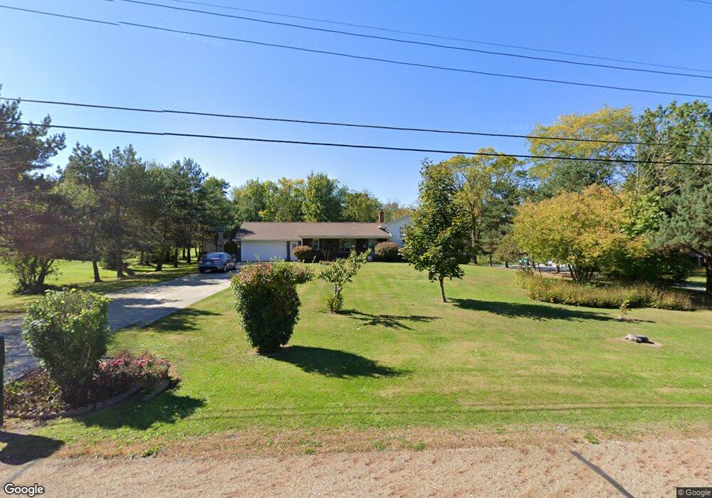
11630 Lyman Rd Chesterland, OH 44026
Estimated Value: $415,000 - $504,000
4
Beds
3
Baths
2,442
Sq Ft
$185/Sq Ft
Est. Value
About This Home
This home is located at 11630 Lyman Rd, Chesterland, OH 44026 and is currently estimated at $451,872, approximately $185 per square foot. 11630 Lyman Rd is a home located in Geauga County with nearby schools including West Geauga High School, St Anselm School, and Hawken Upper School.
Ownership History
Date
Name
Owned For
Owner Type
Purchase Details
Closed on
Apr 6, 2000
Sold by
Arra Rosetta J and Arra Rosetta J
Bought by
Spreger Richard J and Spreger Jacqueline
Current Estimated Value
Home Financials for this Owner
Home Financials are based on the most recent Mortgage that was taken out on this home.
Original Mortgage
$150,000
Outstanding Balance
$44,070
Interest Rate
6.25%
Estimated Equity
$407,802
Purchase Details
Closed on
May 22, 1990
Bought by
Arra Rosetta J
Create a Home Valuation Report for This Property
The Home Valuation Report is an in-depth analysis detailing your home's value as well as a comparison with similar homes in the area
Home Values in the Area
Average Home Value in this Area
Purchase History
| Date | Buyer | Sale Price | Title Company |
|---|---|---|---|
| Spreger Richard J | $185,000 | -- | |
| Arra Rosetta J | $135,000 | -- |
Source: Public Records
Mortgage History
| Date | Status | Borrower | Loan Amount |
|---|---|---|---|
| Open | Spreger Richard J | $150,000 | |
| Closed | Spreger Richard J | $35,000 |
Source: Public Records
Tax History Compared to Growth
Tax History
| Year | Tax Paid | Tax Assessment Tax Assessment Total Assessment is a certain percentage of the fair market value that is determined by local assessors to be the total taxable value of land and additions on the property. | Land | Improvement |
|---|---|---|---|---|
| 2024 | $5,557 | $128,840 | $17,290 | $111,550 |
| 2023 | $5,557 | $128,840 | $17,290 | $111,550 |
| 2022 | $4,959 | $98,630 | $14,420 | $84,210 |
| 2021 | $4,944 | $98,630 | $14,420 | $84,210 |
| 2020 | $5,139 | $98,630 | $14,420 | $84,210 |
| 2019 | $4,626 | $85,790 | $14,420 | $71,370 |
| 2018 | $4,588 | $85,790 | $14,420 | $71,370 |
| 2017 | $4,626 | $85,790 | $14,420 | $71,370 |
| 2016 | $4,918 | $86,240 | $16,240 | $70,000 |
| 2015 | $4,554 | $86,240 | $16,240 | $70,000 |
| 2014 | $4,554 | $86,240 | $16,240 | $70,000 |
| 2013 | $4,586 | $86,240 | $16,240 | $70,000 |
Source: Public Records
Map
Nearby Homes
- 8075 Mulberry Rd
- 0 Merrie Ln
- 8371 Cranwood Dr
- 11925 Caves Rd
- 11065 Chillicothe Rd
- 8494 Sharp Ln
- VL Palomino Trail
- 12120 Caves Rd
- 11865 Africa Acres Dr
- 10899 Tibbetts Rd
- 12470 Caves Rd
- 11240 W Walnut Ridge Rd
- 8141 Euclid Chardon Rd
- 8051 Euclid Chardon Rd
- 10640 Bayshire Trail
- V/L Heath Rd
- 7959 Gates Mills Estates
- 10515 Gaitside Trail
- 560 County Line Rd
- 9610 Wilson Mills Rd
- 11644 Lyman Rd
- 11620 Lyman Rd
- 11654 Lyman Rd
- 11664 Lyman Rd
- 11631 Lyman Rd
- 11610 Lyman Rd
- 11621 Lyman Rd
- 11645 Lyman Rd
- 8239 Mulberry Rd
- 11655 Lyman Rd
- 8263 Mulberry Rd
- 11674 Lyman Rd
- 11665 Lyman Rd
- 8313 Mulberry Rd
- 11688 Lyman Rd
- 11675 Lyman Rd
- 8323 Mulberry Rd
- 11689 Lyman Rd
- 8270 Mulberry Rd
- 11700 Lyman Rd