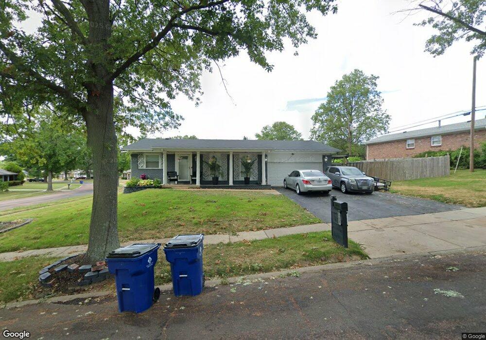
11637 MacRinus Dr Florissant, MO 63033
Estimated Value: $200,022 - $234,000
3
Beds
2
Baths
1,400
Sq Ft
$155/Sq Ft
Est. Value
About This Home
This home is located at 11637 MacRinus Dr, Florissant, MO 63033 and is currently estimated at $217,256, approximately $155 per square foot. 11637 MacRinus Dr is a home located in St. Louis County with nearby schools including Jury Elementary School, Central Middle School, and Hazelwood Central High School.
Ownership History
Date
Name
Owned For
Owner Type
Purchase Details
Closed on
Mar 25, 1999
Sold by
Brooks Joyce R Ward and Brooks John J
Bought by
Thomas Lola Y
Current Estimated Value
Home Financials for this Owner
Home Financials are based on the most recent Mortgage that was taken out on this home.
Original Mortgage
$82,000
Outstanding Balance
$19,964
Interest Rate
6.82%
Estimated Equity
$197,292
Purchase Details
Closed on
Apr 4, 1997
Sold by
Hud
Bought by
Brooks John L and Brooks Joyce R Ward
Home Financials for this Owner
Home Financials are based on the most recent Mortgage that was taken out on this home.
Original Mortgage
$51,100
Interest Rate
11%
Purchase Details
Closed on
Jan 27, 1997
Sold by
Principal Residential Mtg Inc
Bought by
Hud
Create a Home Valuation Report for This Property
The Home Valuation Report is an in-depth analysis detailing your home's value as well as a comparison with similar homes in the area
Home Values in the Area
Average Home Value in this Area
Purchase History
| Date | Buyer | Sale Price | Title Company |
|---|---|---|---|
| Thomas Lola Y | $90,000 | -- | |
| Brooks John L | -- | -- | |
| Hud | -- | First American Title Ins Co |
Source: Public Records
Mortgage History
| Date | Status | Borrower | Loan Amount |
|---|---|---|---|
| Open | Thomas Lola Y | $82,000 | |
| Previous Owner | Brooks John L | $51,100 | |
| Closed | Thomas Lola Y | $7,500 |
Source: Public Records
Tax History Compared to Growth
Tax History
| Year | Tax Paid | Tax Assessment Tax Assessment Total Assessment is a certain percentage of the fair market value that is determined by local assessors to be the total taxable value of land and additions on the property. | Land | Improvement |
|---|---|---|---|---|
| 2025 | $3,044 | $38,740 | $5,550 | $33,190 |
| 2024 | $3,044 | $33,450 | $3,710 | $29,740 |
| 2023 | $3,044 | $33,450 | $3,710 | $29,740 |
| 2022 | $2,709 | $26,540 | $6,480 | $20,060 |
| 2021 | $2,565 | $26,540 | $6,480 | $20,060 |
| 2020 | $2,518 | $24,270 | $4,260 | $20,010 |
| 2019 | $2,477 | $24,270 | $4,260 | $20,010 |
| 2018 | $2,407 | $21,800 | $2,950 | $18,850 |
| 2017 | $2,404 | $21,800 | $2,950 | $18,850 |
| 2016 | $2,425 | $21,630 | $3,330 | $18,300 |
| 2015 | $2,369 | $21,630 | $3,330 | $18,300 |
| 2014 | $2,073 | $18,810 | $3,250 | $15,560 |
Source: Public Records
Map
Nearby Homes
- 11636 MacRinus Dr
- 4493 Caracalla Dr
- 12062 Cato Dr
- 11767 MacRinus Dr
- 4471 Rhine Dr
- 4497 Rhine Dr
- 4461 Rhine Dr
- 4348 Vandals Dr
- 4384 Remus Dr
- 4354 Metarus Dr
- 4401 Rhine Dr
- 11565 Mehl Ave
- 4950 Patricia Ridge Dr
- 11869 Galba Dr
- 11540 Lares Dr
- 11790 New Halls Ferry Rd
- 4244 Miletus Dr
- 30 Rolling Hills Dr
- 12415 Danube Dr
- 4040 Helmkampf Dr
- 11647 MacRinus Dr
- 11617 MacRinus Dr
- 4487 Caracalla Dr
- 11646 MacRinus Dr
- 11677 MacRinus Dr
- 11626 MacRinus Dr
- 4486 Caracalla Dr
- 11656 MacRinus Dr
- 12042 Cato Dr
- 11616 MacRinus Dr
- 4483 Caracalla Dr
- 11676 MacRinus Dr
- 11687 MacRinus Dr
- 12032 Cato Dr
- 11607 MacRinus Dr
- 4482 Caracalla Dr
- 11599 Galba Dr
- 11609 Galba Dr
- 11686 MacRinus Dr
- 4509 Papal Dr