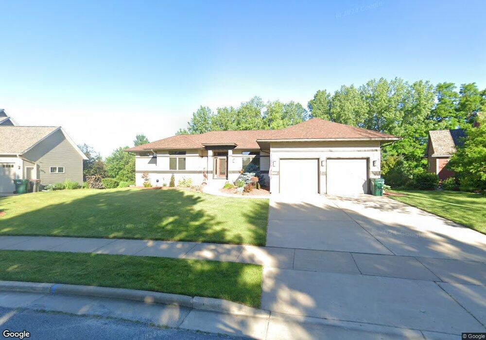
1165 Vail Way N Hudson, WI 54016
Estimated Value: $593,860 - $648,000
--
Bed
--
Bath
--
Sq Ft
0.39
Acres
About This Home
This home is located at 1165 Vail Way N, Hudson, WI 54016 and is currently estimated at $614,715. 1165 Vail Way N is a home located in St. Croix County with nearby schools including North Hudson Elementary School, Hudson Middle School, and Hudson High School.
Ownership History
Date
Name
Owned For
Owner Type
Purchase Details
Closed on
Apr 19, 2007
Sold by
Dcci Land Planners Inc
Bought by
Foster Thomas J and Foster Joan M
Current Estimated Value
Create a Home Valuation Report for This Property
The Home Valuation Report is an in-depth analysis detailing your home's value as well as a comparison with similar homes in the area
Home Values in the Area
Average Home Value in this Area
Purchase History
| Date | Buyer | Sale Price | Title Company |
|---|---|---|---|
| Foster Thomas J | -- | None Available |
Source: Public Records
Tax History Compared to Growth
Tax History
| Year | Tax Paid | Tax Assessment Tax Assessment Total Assessment is a certain percentage of the fair market value that is determined by local assessors to be the total taxable value of land and additions on the property. | Land | Improvement |
|---|---|---|---|---|
| 2024 | $67 | $515,600 | $76,200 | $439,400 |
| 2023 | $6,457 | $515,600 | $76,200 | $439,400 |
| 2022 | $7,072 | $515,600 | $76,200 | $439,400 |
| 2021 | $6,927 | $346,300 | $75,900 | $270,400 |
| 2020 | $6,690 | $346,300 | $75,900 | $270,400 |
| 2019 | $6,250 | $346,300 | $75,900 | $270,400 |
| 2018 | $6,206 | $346,300 | $75,900 | $270,400 |
| 2017 | $5,974 | $346,300 | $75,900 | $270,400 |
| 2016 | $5,974 | $346,300 | $75,900 | $270,400 |
| 2015 | $5,491 | $346,300 | $75,900 | $270,400 |
| 2014 | $5,445 | $346,300 | $75,900 | $270,400 |
| 2013 | $5,535 | $355,500 | $84,000 | $271,500 |
Source: Public Records
Map
Nearby Homes
- 1302 10th St N
- 241 Starrwood
- 1110 Partridge Ln N
- 1115 Willow River Rd N
- 627 8th St N
- 702 4th St N
- 1100 Michaelson St N
- 603 10th St N
- 233 River Heights Trail
- 606 6th St N
- 412 Helen St N
- 1094 Golden Oaks Ln
- 888 Bluebird Ct N
- 296 Valley Estates Ct
- 1205 Riverside Dr N
- 1205 Riverside Drive N
- 530 Lakeside Bay Dr S
- 388 Brookwood Dr
- 560 Lakeside Bay Dr S Unit 560
- 479 Mariner Dr
- 1155 Vail Way N
- 1175 Vail Way N
- 907 Kirkwood Way N
- 1185 Vail Way N
- 1145 Vail Way N
- 1170 Vail Way N
- 1150 Vail Way N
- 1012 N Star Ridge N
- 1135 10th St N
- 1190 Vail Way N
- 1195 Vail Way N
- 1203 10 St N
- 1203 10th St N
- 1014 N Star Ridge N
- 1207 10th St N
- 1200 10th St N
- 1006 Alta Ave N
- 1210 Vail Way N
- 1215 10th St N
- 908 Kirkwood Way N