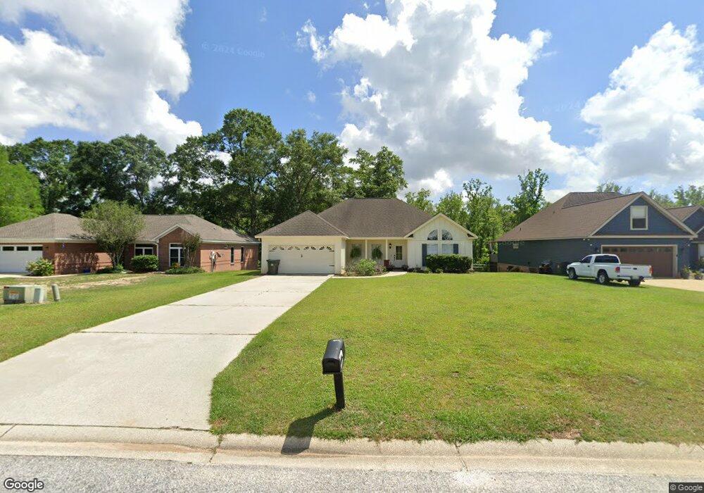
11660 Branchwood Dr Fairhope, AL 36532
Estimated Value: $353,000 - $384,000
4
Beds
2
Baths
2,100
Sq Ft
$177/Sq Ft
Est. Value
About This Home
This home is located at 11660 Branchwood Dr, Fairhope, AL 36532 and is currently estimated at $372,481, approximately $177 per square foot. 11660 Branchwood Dr is a home located in Baldwin County with nearby schools including Fairhope East Elementary, Fairhope Middle School, and Fairhope High School.
Ownership History
Date
Name
Owned For
Owner Type
Purchase Details
Closed on
Oct 15, 2014
Sold by
Beard Melanie White
Bought by
Beard Anthony Paul
Current Estimated Value
Purchase Details
Closed on
Jul 29, 2008
Sold by
Drinkard Everette E and Drinkard Suzette
Bought by
Beard Anthony P and Beard Melanie W
Home Financials for this Owner
Home Financials are based on the most recent Mortgage that was taken out on this home.
Original Mortgage
$167,200
Outstanding Balance
$109,953
Interest Rate
6.37%
Mortgage Type
Purchase Money Mortgage
Estimated Equity
$262,528
Create a Home Valuation Report for This Property
The Home Valuation Report is an in-depth analysis detailing your home's value as well as a comparison with similar homes in the area
Home Values in the Area
Average Home Value in this Area
Purchase History
| Date | Buyer | Sale Price | Title Company |
|---|---|---|---|
| Beard Anthony Paul | $158,000 | None Available | |
| Beard Anthony P | -- | None Available |
Source: Public Records
Mortgage History
| Date | Status | Borrower | Loan Amount |
|---|---|---|---|
| Open | Beard Anthony P | $167,200 |
Source: Public Records
Tax History Compared to Growth
Tax History
| Year | Tax Paid | Tax Assessment Tax Assessment Total Assessment is a certain percentage of the fair market value that is determined by local assessors to be the total taxable value of land and additions on the property. | Land | Improvement |
|---|---|---|---|---|
| 2024 | $1,097 | $35,060 | $6,240 | $28,820 |
| 2023 | $986 | $31,820 | $4,940 | $26,880 |
| 2022 | $830 | $26,760 | $0 | $0 |
| 2021 | $760 | $24,280 | $0 | $0 |
| 2020 | $736 | $23,740 | $0 | $0 |
| 2019 | $633 | $22,600 | $0 | $0 |
| 2018 | $600 | $21,420 | $0 | $0 |
| 2017 | $574 | $20,500 | $0 | $0 |
| 2016 | $579 | $20,680 | $0 | $0 |
| 2015 | $1,144 | $40,440 | $0 | $0 |
| 2014 | $1,067 | $37,700 | $0 | $0 |
| 2013 | -- | $38,040 | $0 | $0 |
Source: Public Records
Map
Nearby Homes
- 11633 County Road 48
- 11433 Warrie Creek Alley
- 11418 Belize River St Unit 36
- 20363 Cadena Creek Ave
- 0 Kenneth King Ln
- 19520 Gunnison Rd
- 20011 Lawrence Rd
- 21021 Rachel Myers Ln
- 0 Langford Rd Unit 2 377615
- 0 Langford Rd Unit 7560365
- 21151 Caveletti Cir
- 20752 Southwood St
- 12293 Comalander Rd
- 19740 Bunker Loop
- 12306 Dressage Way
- 10832 Mashie Ln
- 10929 Covey Dr
- 668 Overland Dr
- 19741 Bunker Loop
- 684 Overland Dr
- 11674 Branchwood Dr
- 11650 Branchwood Dr
- 11626 Branchwood Dr
- 11690 Branchwood Dr
- 11612 Branchwood Dr
- 11700 Branchwood Dr
- 11606 Branchwood Dr
- 11712 Branchwood Dr
- 11667 Branchwood Dr
- 11643 Branchwood Dr
- 11681 Branchwood Dr
- 11582 Branchwood Dr
- 11639 Branchwood Dr
- 11691 Branchwood Dr
- 11715 Branchwood Dr
- 11617 Branchwood Dr
- 11609 Branchwood Dr
- 11568 Branchwood Dr
- 11709 Branchwood Dr
- 11701 Branchwood Dr