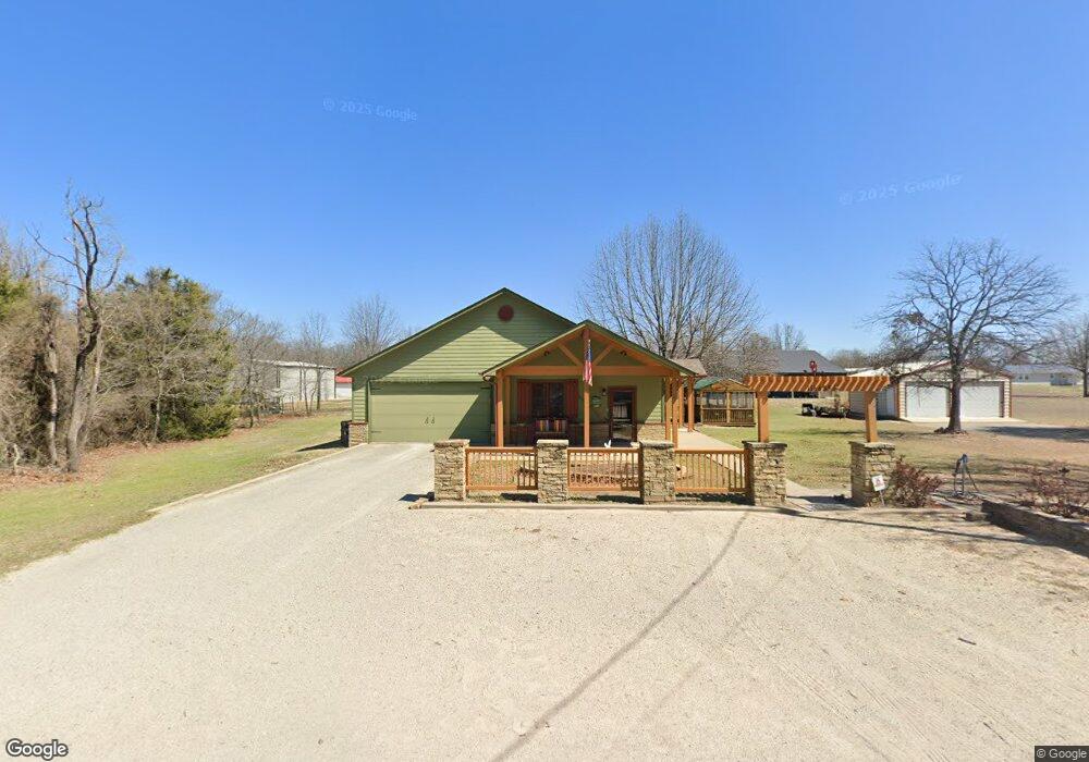
116685 S 4206 Rd Eufaula, OK 74432
Estimated Value: $244,558 - $336,000
2
Beds
2
Baths
1,660
Sq Ft
$178/Sq Ft
Est. Value
About This Home
This home is located at 116685 S 4206 Rd, Eufaula, OK 74432 and is currently estimated at $295,390, approximately $177 per square foot. 116685 S 4206 Rd is a home located in McIntosh County with nearby schools including Eufaula Elementary School, Eufaula Middle School, and Eufaula High School.
Ownership History
Date
Name
Owned For
Owner Type
Purchase Details
Closed on
Jun 13, 2025
Sold by
Cook George and Cook Vicki
Bought by
Lokey Troy and Lokey Sue
Current Estimated Value
Home Financials for this Owner
Home Financials are based on the most recent Mortgage that was taken out on this home.
Original Mortgage
$239,780
Outstanding Balance
$237,337
Interest Rate
4%
Mortgage Type
VA
Estimated Equity
$58,053
Create a Home Valuation Report for This Property
The Home Valuation Report is an in-depth analysis detailing your home's value as well as a comparison with similar homes in the area
Purchase History
| Date | Buyer | Sale Price | Title Company |
|---|---|---|---|
| Lokey Troy | $243,000 | None Listed On Document |
Source: Public Records
Mortgage History
| Date | Status | Borrower | Loan Amount |
|---|---|---|---|
| Open | Lokey Troy | $239,780 |
Source: Public Records
Tax History
| Year | Tax Paid | Tax Assessment Tax Assessment Total Assessment is a certain percentage of the fair market value that is determined by local assessors to be the total taxable value of land and additions on the property. | Land | Improvement |
|---|---|---|---|---|
| 2025 | $1,541 | $17,612 | $459 | $17,153 |
| 2024 | $1,365 | $16,409 | $511 | $15,898 |
| 2023 | $1,365 | $14,883 | $367 | $14,516 |
| 2022 | $1,176 | $14,175 | $350 | $13,825 |
| 2021 | $1,133 | $13,500 | $330 | $13,170 |
| 2020 | $1,133 | $13,500 | $330 | $13,170 |
| 2019 | $736 | $13,500 | $330 | $13,170 |
| 2018 | $700 | $9,685 | $237 | $9,448 |
| 2017 | $677 | $9,129 | $194 | $8,935 |
| 2016 | $658 | $8,863 | $178 | $8,685 |
| 2015 | $628 | $8,605 | $178 | $8,427 |
| 2014 | $603 | $8,354 | $171 | $8,183 |
Source: Public Records
Map
Nearby Homes
- 420707 E 1166 Rd
- 116307 S 4209 Rd
- 116965 S 4164
- 115292 S Forsman
- 1 E 1167 Rd
- 421171 E 1168 Rd
- 114996 S 4212 Rd
- 001 Siers Rd
- 002 E 1168 Rd
- 001 E 1168 Rd
- 116565 S 4213 Rd
- 421317 E 1168 Rd
- 421298 E 1168 Rd
- 421355 E 1168 Rd
- 117525 S 4209 Rd
- 0 Lynn Ln Unit 2538038
- 117672 S 4202 Rd
- 115756 N 4199 Rd
- 115847 S 4197 Rd
- 123 S 4214 Loop
- 116694 S 4206 Rd
- 0 S 4206 Rd Unit 1936246
- 0 S 4206 Rd Unit 2007721
- 0 Belle Starr Rd Unit 1710967
- 0 None Unit 1009455
- 116674 S 4206 Rd
- Rr 2 Po Box
- 116660 S 4206 Rd
- 116636 S 4206 Rd
- 17860 Creekwood Ln
- 420645 E 1168 Rd
- 24 Heathway Rd
- 1425 Hisel Rd
- 1716 Westminster Place
- 2885 Rr 4
- Rt 4 Box 1042 Rr 4
- Rt 4 Box 1214 Rr 4
- 1425 Hisel Rd
- 101 Belle Starr Forest Dr
- 420639 E 1166 Rd