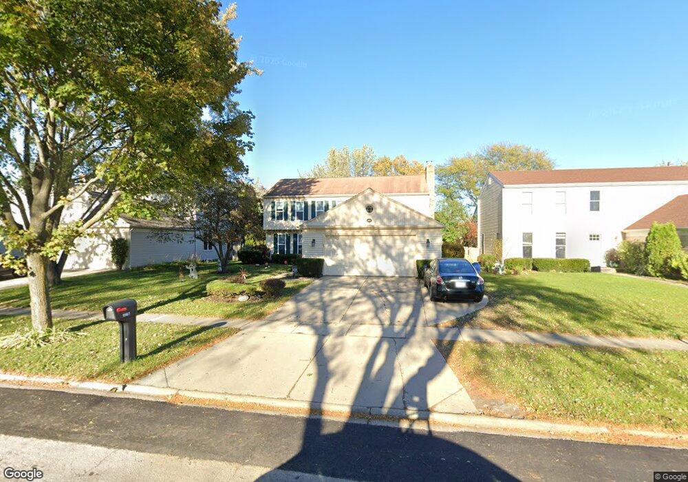
1167 Gail Dr Buffalo Grove, IL 60089
Estimated Value: $610,202 - $673,000
--
Bed
3
Baths
2,468
Sq Ft
$257/Sq Ft
Est. Value
About This Home
This home is located at 1167 Gail Dr, Buffalo Grove, IL 60089 and is currently estimated at $634,301, approximately $257 per square foot. 1167 Gail Dr is a home located in Lake County with nearby schools including Prairie Elementary School, Twin Groves Middle School, and Adlai E Stevenson High School.
Ownership History
Date
Name
Owned For
Owner Type
Purchase Details
Closed on
Jun 2, 2011
Sold by
Tarnoff Dan A and Tarnoff Sharon J
Bought by
Tarnoff Dan A and Tarnoff Sharon J
Current Estimated Value
Purchase Details
Closed on
Nov 28, 1995
Sold by
Kronowitz Norman and Kronowitz Susan M
Bought by
Tarnoff Dan A and Tarnoff Sharon J
Home Financials for this Owner
Home Financials are based on the most recent Mortgage that was taken out on this home.
Original Mortgage
$180,000
Outstanding Balance
$3,551
Interest Rate
7%
Estimated Equity
$630,750
Create a Home Valuation Report for This Property
The Home Valuation Report is an in-depth analysis detailing your home's value as well as a comparison with similar homes in the area
Home Values in the Area
Average Home Value in this Area
Purchase History
| Date | Buyer | Sale Price | Title Company |
|---|---|---|---|
| Tarnoff Dan A | -- | None Available | |
| Tarnoff Dan A | $245,000 | -- |
Source: Public Records
Mortgage History
| Date | Status | Borrower | Loan Amount |
|---|---|---|---|
| Open | Tarnoff Dan A | $180,000 |
Source: Public Records
Tax History Compared to Growth
Tax History
| Year | Tax Paid | Tax Assessment Tax Assessment Total Assessment is a certain percentage of the fair market value that is determined by local assessors to be the total taxable value of land and additions on the property. | Land | Improvement |
|---|---|---|---|---|
| 2024 | $15,543 | $186,421 | $36,931 | $149,490 |
| 2023 | $14,529 | $167,526 | $33,188 | $134,338 |
| 2022 | $14,529 | $150,338 | $29,783 | $120,555 |
| 2021 | $14,481 | $148,717 | $29,462 | $119,255 |
| 2020 | $14,140 | $149,225 | $29,563 | $119,662 |
| 2019 | $13,945 | $148,675 | $29,454 | $119,221 |
| 2018 | $9,673 | $145,325 | $29,108 | $116,217 |
| 2017 | $12,949 | $141,933 | $28,429 | $113,504 |
| 2016 | $12,614 | $135,912 | $27,223 | $108,689 |
| 2015 | $12,284 | $127,104 | $25,459 | $101,645 |
| 2014 | $11,447 | $117,230 | $27,344 | $89,886 |
| 2012 | $11,396 | $117,465 | $27,399 | $90,066 |
Source: Public Records
Map
Nearby Homes
- 1315 Gail Dr
- 810 Silver Rock Ln
- 938 Hidden Lake Dr
- 760 Checker Dr
- 531 Lasalle Ln
- 620 Twisted Oak Ln
- 630 Woodhollow Ln
- 1327 Larchmont Dr
- 1272 Sandhurst Dr
- 131 Autumn Ct Unit CT10602
- 12 Cloverdale Ct
- 5107 N Arlington Heights Rd
- 690 Dunhill Dr
- 412 Chateau Dr
- 1325 Fairfax Ln
- 5135 Bridlewood Ct
- 1117 Franklin Ln Unit C52
- 153 E Fabish Dr
- 728 Old Checker Rd Unit C4
- 268 Hoffmann Dr
- 1159 Gail Dr
- 1175 Gail Dr
- 1198 Green Knolls Dr
- 1151 Gail Dr
- 1183 Gail Dr
- 1206 Green Knolls Dr
- 1190 Green Knolls Dr
- 1143 Gail Dr
- 1191 Gail Dr
- 1174 Gail Dr
- 1166 Gail Dr
- 1182 Green Knolls Dr
- 1214 Green Knolls Dr
- 1182 Gail Dr
- 1158 Gail Dr
- 1144 Gail Dr
- 1170 Green Knolls Dr
- 1131 Gail Dr
- 1203 Gail Dr
- 1190 Gail Dr