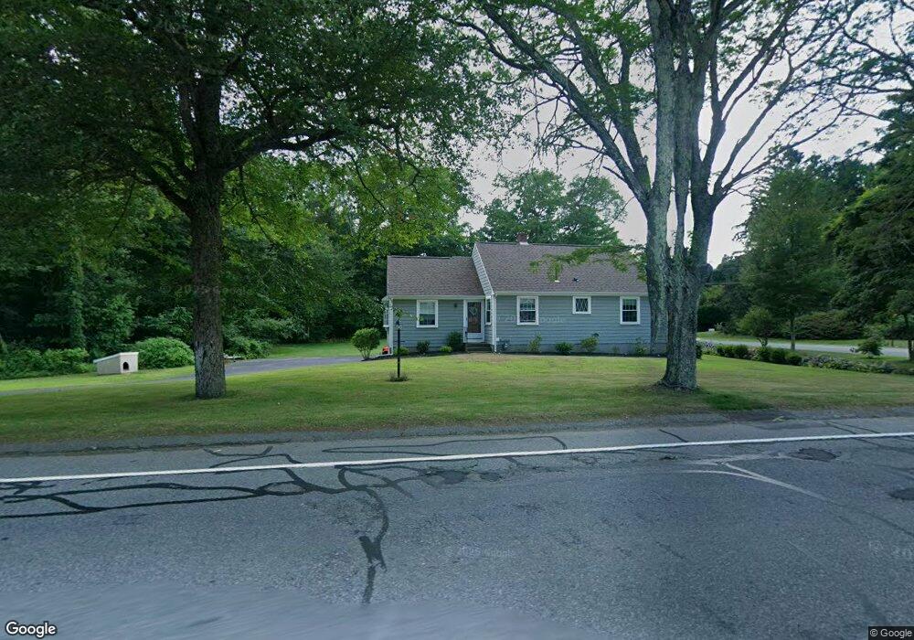
1167 Whitman St Hanson, MA 02341
Estimated Value: $622,049 - $793,000
2
Beds
3
Baths
2,018
Sq Ft
$337/Sq Ft
Est. Value
About This Home
This home is located at 1167 Whitman St, Hanson, MA 02341 and is currently estimated at $679,512, approximately $336 per square foot. 1167 Whitman St is a home located in Plymouth County with nearby schools including St Bridget School.
Ownership History
Date
Name
Owned For
Owner Type
Purchase Details
Closed on
Sep 28, 1990
Sold by
Jamrog Roy A
Bought by
Ryan Timothy P
Current Estimated Value
Home Financials for this Owner
Home Financials are based on the most recent Mortgage that was taken out on this home.
Original Mortgage
$128,000
Interest Rate
9.95%
Mortgage Type
Purchase Money Mortgage
Create a Home Valuation Report for This Property
The Home Valuation Report is an in-depth analysis detailing your home's value as well as a comparison with similar homes in the area
Home Values in the Area
Average Home Value in this Area
Purchase History
We collect this data history from publicly available records. To have your information removed, we recommend requesting removal directly through your county’s website.
| Date | Buyer | Sale Price | Title Company |
|---|---|---|---|
| Ryan Timothy P | $162,000 | -- |
Source: Public Records
Mortgage History
We collect this data history from publicly available records. To have your information removed, we recommend requesting removal directly through your county’s website.
| Date | Status | Borrower | Loan Amount |
|---|---|---|---|
| Closed | Ryan Timothy P | $112,000 | |
| Closed | Ryan Timothy P | $123,000 | |
| Closed | Ryan Timothy P | $128,000 |
Source: Public Records
Tax History
| Year | Tax Paid | Tax Assessment Tax Assessment Total Assessment is a certain percentage of the fair market value that is determined by local assessors to be the total taxable value of land and additions on the property. | Land | Improvement |
|---|---|---|---|---|
| 2025 | $6,632 | $495,700 | $163,000 | $332,700 |
| 2024 | $6,442 | $481,500 | $158,300 | $323,200 |
| 2023 | $6,295 | $443,900 | $158,300 | $285,600 |
| 2022 | $5,632 | $373,200 | $143,900 | $229,300 |
| 2021 | $5,042 | $333,900 | $138,300 | $195,600 |
| 2020 | $4,975 | $325,800 | $133,600 | $192,200 |
| 2019 | $4,799 | $309,000 | $131,100 | $177,900 |
| 2018 | $4,705 | $297,200 | $126,000 | $171,200 |
| 2017 | $4,567 | $285,800 | $120,000 | $165,800 |
| 2016 | $4,654 | $281,200 | $120,000 | $161,200 |
| 2015 | $4,381 | $275,200 | $120,000 | $155,200 |
Source: Public Records
Map
Nearby Homes
- 55 Plymouth St Unit 15
- 214 Winter St
- 43 Apollo Rd
- 44 Morningside Dr
- 724 Whitman St
- 177 Pleasant St
- 24 Bowker Ave
- 5 Satucket Rd
- Lot 5 Princeton Way
- 143 Cranberry Rd
- 129 Commercial St
- 12 Driftwood Ln
- 147 South Ave
- 50 Sawmill Ln Unit 5
- 37 Lakeview St
- 659 Washington St
- 361A County Rd
- 361 County Rd
- 126-130 Franklin St
- 56-58 Vernon St
- 1141 Whitman St
- 27 Holly Ridge Dr
- 1142 Whitman St
- 1185 Whitman St
- 1170 Whitman St
- 24 Holly Ridge Dr
- 41 Holly Ridge Dr
- 1117 Whitman St
- 38 Holly Ridge Dr
- 1193 Whitman St
- 1135 Whitman St
- 4 Tag Way
- 1203 Whitman St
- 1198 Whitman St
- 56 Holly Ridge Dr
- 25 Tag Way
- 57 Holly Ridge Dr
- 1095 Whitman St
- 1102 Whitman St
- 1211 Whitman St
Your Personal Tour Guide
Ask me questions while you tour the home.